Best Easy Day Hikes Series
Best Easy Day Hikes Berkshires
Jim Bradley
Help Us Keep This Guide Up to Date
Every effort has been made by the author and editors to make this guide as accurate and useful as possible. However, many things can change after a guide is publishedtrails are rerouted, regulations change, facilities come under new management, etc.
We would appreciate hearing from you concerning your experiences with this guide and how you feel it could be improved and kept up to date. While we may not be able to respond to all comments and suggestions, well take them to heart and well also make certain to share them with the author. Please send your comments and suggestions to the following address:
GPP
Reader Response/Editorial Department
P.O. Box 480
Guilford, CT 06437
Or you may e-mail us at:
editorial@GlobePequot.com
Thanks for your input, and happy trails!
Copyright 2011 by Morris Book Publishing, LLC
ALL RIGHTS RESERVED. No part of this book may be reproduced or transmitted in any form by any means, electronic or mechanical, including photocopying and recording, or by any information storage and retrieval system, except as may be expressly permitted in writing from the publisher. Requests for permission should be addressed to Globe Pequot Press, Attn: Rights and Permissions Department, P.O. Box 480, Guilford, CT 06437.
FalconGuides is an imprint of Globe Pequot Press.
Falcon, FalconGuides, and Outfit Your Mind are registered trademarks of Morris Book Publishing, LLC.
Layout: Kevin Mak
Project editor: Gregory Hyman
Maps by Mapping Specialists Morris Book Publishing, LLC
TOPO! Explorer software and SuperQuad source maps courtesy of National Geographic Maps. For information about TOPO! Explorer, TOPO!, and Nat Geo Maps products, go to www.topo.com or www.natgeomaps.com.
Library of Congress Cataloging-in-Publication data is available on file.
ISBN 978-1-4930-0489-8
The author and Globe Pequot Press assume no liability for accidents happening to, or injuries sustained by, readers who engage in the activities described in this book.
Contents
The Hikes
Acknowledgments
I would like to thank the many rangers and local hikers that were happy to answer questions and listen to me ramble on. Thanks to the many land conservation groups for protecting land and making it available for outdoor recreation. Thanks to friends and family for their continued support and encouragement. A very special thanks to Lisa OBrien: I would have been lost without her love and support.
Introduction
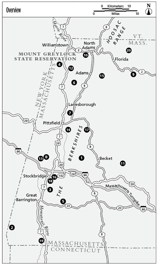
The Berkshires are located in the far west section of Massachusetts, in the rolling hills between New York and Boston. Well known for their natural beauty and ease of access, the Berkshires have inspired great authors and artists such as Nathaniel Hawthorne, Norman Rockwell, Herman Melville, and Henry David Thoreau over the years.
The Appalachian Mountains run northsouth through the region, locally known as the Berkshire Hills. The Taconic Range cuts into the northwest corner of the area and contains Massachusettss highest peak, Mount Greylock (3,491 feet). If you are willing to put the work in, hiking in either of these ranges affords some marvelous views. Dont think the beauty ends there: The Hoosic River and the Housatonic River run through valleys in the Berkshires, a backdrop for possibly more gorgeous scenery than the mountaintops. Many would say to save your trip for peak fall foliage in autumn, when the hills explode with color, but beauty can be found in any season!
The Mahican (muh-he-ka-neew) Native American tribe originally inhabited the area, until the early 1700s when English settlers bought the land from the tribe. In the early 1800s the American elite started building cottages on the hillsides, because the hilly terrain of the Berkshires was not sought after by farmers (although some tried to farm the rocky mountainsides). As the iron industry grew in the late eighteenth and early nineteenth centuries, logging started to become the norm in the Berkshires. Many hillsides were stripped of timber, leaving trees in only the hardest to reach areas.
Today, the Berkshires offer a cultural focal point for historic sites, art, museums, dance, and music venues such as Jacobs Pillow Dance Festival; MASS MoCA, the countrys largest contemporary art center; Tanglewood, the summer home of the Boston Symphony Orchestra; and the Norman Rockwell Museum, just to name a few. Arts and culture come second to outdoor recreation, with opportunities for hiking, backpacking, bicycling, fishing, boating, cross-country and alpine skiing, and hunting scattered all throughout the Berkshires.
The Berkshires seem to have the right balance of small picturesque towns, arts, and protected natural beauty through land conservation. Pittsfield is the largest city in the Berkshires, with a population of around 42,000 people. Some of the smaller towns of the Berkshires, such as Monroe and Mount Washington, have fewer than one hundred residents. The Massachusetts Department of Conservation and Recreation protects and maintains about twenty-five properties, totaling over 115,000 acres, in the Berkshires. Numerous private land-conservation groups also maintain a large number of properties in the area. Hiking and outdoor recreation is strongly supported in the Berkshires.
The Nature of the Berkshires
Berkshires trails range from the rugged and hilly to the flat and paved. Hikes in this guide cover the full spectrum. While by definition a best easy day hike is not strenuous and poses little danger to the traveler, knowing a few details about the nature of the area will enhance your explorations.
Weather
The Berkshires are quite a bit hillier than the rest of the state. Therefore, the weather is a bit more dramatic. You might hear locals say If you dont like the weather, wait ten minutes. This is a bit of a stretch, but strange weather is not uncommon in the Berkshires.
The best weather for hiking is in summer and fall, when high temperatures range from the 40s to the 80s and the spring thaw has passed, allowing the wet trails to dry up. Winter snowmelt and heavy spring rains saturate many area trails, leaving them muddy. Hiking on muddy trails promotes erosion, which in turn creates more muddy trails.
An average of 36 inches of rain falls in the area annually, mostly in spring and early summer. Snowfall averages 70 inches annually, and can remain on the ground well into April, especially at higher elevations and heavily shaded areas. Winter lows can plunge into the negatives, but winter daytime highs are usually in the 20s. When hiking in winter, wear layers of clothing, a hat, and gloves to insulate you from the cold and potential rain or snow.
Summertime temperatures are not oppressive, with averages in the 70s and 80s. In fall, the leaves start to change as the temperature drops; expect temperatures in the 40s, 50s, and 60s in fall months. Peak fall foliage usually happens in the beginning of October but changes year to year.
Critters
You will encounter mostly benign creatures on these trails, such as squirrels, rabbits, turkeys, and a variety of birdlife. More rarely seen are coyotes, deer, moose, bobcat, and black bear. Encounters with wildlife that pose a potential threat to hikers are very rare but are definitely possible, so beware the venomous snake, black bear, moose, and bobcat.


