Natalie L. Bartley
Copyright 2010 by Morris Book Publishing, LLC
ALL RIGHTS RESERVED. No part of this book may be reproduced or transmitted in any form by any means, electronic or mechanical, including photocopying and recording, or by any information storage and retrieval system, except as may be expressly permitted in writing from the publisher. Requests for permission should be addressed to Globe Pequot Press, Attn: Rights and Permissions Department, P.O. Box 480, Guilford, CT 06437.
FalconGuides is an imprint of Globe Pequot Press.
Falcon, FalconGuides, and Outfit Your Mind are registered trademarks of Morris Book Publishing, LLC.
TOPO! Explorer software and SuperQuad source maps courtesy of National Geographic Maps. For information about TOPO! Explorer, TOPO!, and Nat Geo Maps products, go to www.topo.com or www.natgeomaps.com.
Project editor: Gregory Hyman
Layout: Kevin Mak
Maps: OffRoute Inc. Morris Book Publishing, LLC
Library of Congress Cataloging-in-Publication Data is available on file.
ISBN 978-1-4930-0280-1
The author and Globe Pequot Press assume no liability for accidents happening to, or injuries sustained by, readers who engage in the activities described in this book.
Contents
The Hikes
Acknowledgments
Kudos and hugs go to my friends and relatives who traveled the highways and trails with me and read or followed the hike descriptions developed for this guidebook. Heartfelt thanks go to the various land managers and agency representatives for their share in adding to this guides usability through reviewing their specific trails.
Thank you also to the helpful staff at DeLorme Publishing Company, Inc., for their assistance with Global Positioning System (GPS) questions. Last but not least, a big thanks to the staff at Globe Pequot Press, including acquisition editor Scott Adams, the cartographers, copy editors, design artists, production staff, and many others who made this guidebook a reality.
Introduction
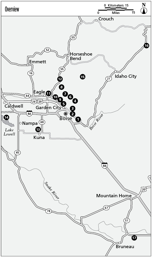
Selecting the seventeen best easy day hikes in Boise and the vicinity is an exciting yet challenging task. From the forested mountains and the lush river valley to the surrounding high desert of the Snake River plain, there are so many outstanding choices within a 60-mile drive of Idahos capital city.
The present-day drainage system of the Boise River, with cities lining its banks and the swath of agricultural land between Mountain Home to the east and Payette near the Idaho-Oregon border to the west, is commonly known as the Treasure Valley. Boise and the surrounding areas are fringed by federal public land managed by the Boise National Forest and the Bureau of Land Management.
Trails in the City of Boises Boise River Greenbelt system are noteworthy for their convenience and tranquility. City managers had the foresight to protect the river corridor for future use as a public trail system. The Boise River Greenbelt stands as a role model for Idaho urban trail systems. Additionally, the cities of Boise, Garden City, and Eagle each have a system of greenbelt pathways along the banks of the Boise River. Toss in city, county, and state public land, and the hiking possibilities bloom.
Numerous property-access agreements with private landowners in the Boise foothills helped create the Ridge to Rivers Trail System. Consisting of more than 125 miles of public-use trails on 80,000 acres of land, the trails are easily accessed from various trailheads along the Boise foothills near Boise.
Included in the Ridge to Rivers Trail System are two nationally designated trails. The Oregon Trail Historic Reserve Trail System is part of the 2,170-mile Oregon National Historic Trail. Hulls Gulch Interpretive Trail, a pedestrian-only trail, is a designated National Recreation Trail.
Geology strongly defines the Treasure Valley. Eight to nine million years ago a lake, named Lake Idaho by geologists, formed between the Boise Ridge to the north and the Owyhee Mountains to the south. The old lake was nearly 35 miles wide and 200 miles long. Indications of the lake are clearly visible from vantage points high above the vast valley. Various layers of volcanic and lake sediments consisting of sand, clay, and pebble remain today. These materials, carried in by river activity and deposited in Lake Idaho, reached greater than 4,000 feet in thickness.
The north edge of the Boise Ridge comprises granodiorite of the Idaho Batholith, with an overlay of volcanic rocks and boulder gravel. Shafer Butte, the highest point in the Boise Ridge, was created by a fault in the area that raised the rocks in the east side of the valley and tipped the rocks downward in the western part of the valley.
Not only is the geology readily visible, it is part of the everyday vocabulary of trail users. During each spring, when vegetation is prolific, cattle and hikers share the drawa shallow gully. After a steep uphill climb, hikers step onto a saddle, the low area connecting two higher points on the ridge. Emigrants on the Oregon Trail were desperate to find a way off the bencha flat, elevated piece of land also called a terraceto the lush river valley below.
Benches in Boise and to the south of the valley were once the bottom of the old lake. They were formed by repetitive glacial growth and melting, excavating the valley. There are several benches in the Treasure Valley. Outlying perimeter benches contain basalt. Other benches are within or near the Boise Rivers hundred-year floodplain.
Hikers in the foothills tread on the edge of the old shoreline of the lake while viewing the extensive valley and benches below. Stand atop Table Rock, the remains of the bottom of the long-lost lake. Learn more about the geology of the Treasure Valley at the Idaho Museum of Mining and Geology, next to the Old Idaho State Penitentiary near the Table RockOld Penitentiary trailhead.
The trails described in this book provide a sampling of the endless number of hiking options in the Boise vicinity. Shaded hikes on smooth paved trails along the glittering Boise River or upland hikes through sagebrush with stunning valley views represent just a few of the options. Discover sand dunes, mountain streams, or historical wagon train trails. It is all there for modern-day explorers.
Weather
Boise is famous for its high-desert climate with steady sunshine, 230 days per year, and low-humidity averaging near 30 percent in summer. Annual rainfall averages 12 inches, with the majority of precipitation occurring October through March.
Winters are often moderate in town, with snow remaining on the ground only for a day or two. In the mountains, snow falls from October through May and is usually associated with foggy conditions. Fog frequents the valley from late November through mid-February during times of temperature inversions. Higher elevation trails in the foothills and the trails beyond Boise enable hikers to get above the inversion for a shot of sunshine.
July is the hottest month in the Treasure Valley, with average daytime temperatures around 90 degrees Fahrenheit and nighttime lows around 62 degrees. In general, plan for hot weather on Boise foothills hikes during late spring, summer, and early fall. On the hottest days, temperatures can hit 100 degrees by midday and remain hot until late evening after the sun goes down. Temperatures can be even hotter during heat waves, soaring as high as 105 degrees.


