About the Author
The author has a serious problemhe doesnt know what he wants to do when he grows up. Meanwhile, hes done such things as wildland fire fighting, running a mountain shop, flying airplanes, shooting photos, and writing books. Hes a backcountry skier, climber, figure skater, mountain biker, amateur radio operator, river runner, and sea kayakerbut the thing that really floats his boat is hiking and backpacking. No matter what else he tries, the author always comes back to hikingespecially long, rough, cross-country trips in places like the Grand Canyon. Some people never learn. But what little he has learned, hes willing to share with youvia his books, of course, but also via his websites, blogs, and whatever works. His website is BruceGrubbs.com.
His other FalconGuides include: Basic Essentials: Using GPS; Best Easy Day Hikes Albuquerque; Best Easy Day Hikes Flagstaff; Best Easy Day Hikes Las Vegas; Best Easy Day Hikes Sedona; Best Easy Day Hikes Tucson; Best Hikes Near Phoenix; Camping Arizona; Desert Hiking Tips; Explore! Joshua Tree National Park; Explore! Mount Shasta Country; Grand Canyon National Park Pocket Guide; Falcon Guide to Saguaro National Park and the Santa Catalina Mountains; Hiking Arizona; Hiking Arizonas Superstition and Mazatzal Country; Hiking Great Basin National Park; Hiking Northern Arizona; Hiking Oregons Central Cascades; Joshua Tree National Park Pocket Guide; Mountain Biking St. George and Cedar City; Mountain Biking Flagstaff and Sedona; and Mountain Biking Phoenix.
Acknowledgments
Special thanks to Jim Foote, Santa Rosa and San Jacinto Mountains National Monument, and Therese Everett-Kerley, Indian Canyons, for reviewing the manuscript. I would also like to thank my many hiking companions down the years, whove put up with my incessant trail mapping and photography. Thanks to Duart Martin, for her constant support and encouragement. And thanks to my editors and Rowman & Littlefield, David Legere and Alex Bordelon, for turning my rough manuscript into a polished book. Finally, thanks to Melissa Baker for her usual fine work on the maps.
Palm Springs
These trails start right on the edge of Palm Springs, in the foothills of the San Jacinto and northern Santa Rosa Mountains. Since they are only a few minutes drive from most of the city, they are very convenient, whether youre a resident or a visitor staying in Palm Springs.
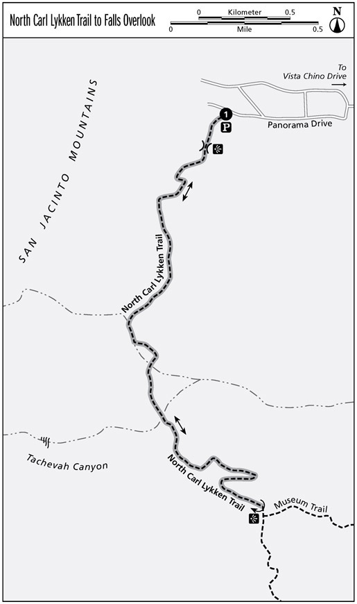
North Carl Lykken Trail to Falls Overlook
The north end of the Carl Lykken Trail system doesnt get as much use as the other trailheads, and its just as scenic. A steep but short climb leads to a saddle and viewpoint, followed by a scenic traverse along the base of the San Jacinto Mountains. Finally, you climb to a point on a ridge overlooking a seasonal waterfall.
Distance: 4.6 miles out and back
Approximate hiking time: 2 hours
Difficulty: Moderate
Trail surface: Dirt and rocks
Best seasons: Oct through Mar
Water availability: None
Other trail users: Mountain bikes and horses
Canine compatibility: Dogs not allowed
Maps: USGS Palm Springs; Santa Rosa and San Jacinto Mountains National Monument Trail Map
Fees and permits: None
Trail contact: Santa Rosa and San Jacinto Mountains National Monument Visitor Center, 51-500 Highway 74, Palm Desert, CA 92260; (760) 862-9984; www.blm.gov/ca/st/en/fo/palmsprings/santarosa.html
Special considerations: During the summer hike early in the day, carry plenty of water, and plan to be finished with the hike by midmorning.
Finding the trailhead: From Palm Springs at the intersection of East Palm Canyon Drive and South Palm Canyon Drive, drive north on South Palm Canyon Drive until it crosses Tahquitz Canyon Way. After 3 miles, turn left on Vista Chino Drive. Continue 0.3 mile and then turn right on Via Norte. Drive 0.1 mile and then turn left on West Chino Canyon Drive. After 0.2 mile, turn left on Panorama Drive and continue 0.5 mile to the unsigned trailhead in a small cul-de-sac on the left, just before the end of the road. GPS: N33 50.722' W116 33.694'
The Hike
The North Carl Lykken Trail climbs the steep slope south of the trailhead in a series of short and very steep switchbacks. The upside of the steep climb is that the trail quickly reaches a saddle with a good view of the north end of Palm Springs. You can also see the trail ahead, cutting across the lower slopes of the mountains. A gentle descent via a couple of broad switchbacks leads to a point where the trail levels out just above the base of the mountainside.
After contouring south along this slope, the North Carl Lykken Trail crosses the bajada slope at the mouth of a short, steep, unnamed canyon. A bajada slope forms along the base of a desert mountain range where outwash debris fans from several adjacent canyons merge to form a broad, gentle slope of flood debris. The bajada lies between the base of the steep mountain slopes and the flat valley floor. This bajada slope is quite small, mainly consisting of the debris from the nameless canyon and Tachevah Canyon farther along the trail. Some bajada slopes run for miles along the base of the mountains, and may even meet the bajada slope from an adjacent mountain range, forming a valley with a shallow V-shaped profile.
From the bajada, the trail descends slightly, then follows the base of the mountainside and emerges into the outwash plain of Tachevah Canyon. At a junction, stay left on the North Carl Lykken Trail. The trail climbs steeply up a north-facing slope to a viewpoint on the ridge crest overlooking a seasonal waterfall. In the spring after a wet winter, snowmelt can send a good flow over the fall. At other times it may be a trickle. The granite cliffs in this area are also popular with rock climbers, and you may see or hear them on the cliffs.
Miles and Directions
0.0 Start at the trailhead.
0.2 Reach the saddle and viewpoint.
0.7 The trail levels out and contours south near the base of the slope.
1.0 Cross a broad bajada slope.
1.3 Skirt the base of the mountain slope.
1.5 At the trail junction, stay left on the North Carl Lykken Trail and follow it south to the top of the ridge.
2.3 Arrive at viewpoint. Return the way you came.
4.6 Arrive back at the trailhead.
North Carl Lykken Trail to Museum Trail
The south end of the North Carl Lykken Trail climbs steadily up the steep mountain slopes above Palm Springs, winding through granite boulders to a point on a ridge overlooking a seasonal waterfall in Tachevah Canyon. It is a short distance down the Museum Trail to a picnic area with a sweeping view of Palm Springs and the Coachella Valley.
Distance: 1.6 miles out and back
Approximate hiking time: 2 hours
Difficulty: Moderate
Trail surface: Dirt and rocks
Best seasons: Oct through Mar
Water availability: None
Other trail users: Mountain bikes and horses
Canine compatibility: Dogs not allowed
Maps: USGS Palm Springs; Santa Rosa and San Jacinto Mountains National Monument Trail Map
Fees and permits: None
Trail contact: Santa Rosa and San Jacinto Mountains National Monument Visitor Center, 51-500 Highway 74, Palm Desert, CA 92260; (760) 862-9984; www.blm.gov/ca/st/en/fo/palmsprings/santarosa.html


