Best Easy Day Hikes Series
Best Easy Day Hikes Sedona
Second Edition
Bruce Grubbs
Help Us Keep This Guide Up to Date
Every effort has been made by the author and editors to make this guide as accurate and useful as possible. However, many things can change after a guide is publishedtrails are rerouted, regulations change, facilities come under new management, and so forth.
We would love to hear from you concerning your experiences with this guide and how you feel it could be improved and kept up to date. While we may not be able to respond to all comments and suggestions, well take them to heart and well also make certain to share them with the author. Please send your comments and suggestions to the following address:
The Globe Pequot Press
Reader Response/Editorial Department
P.O. Box 480
Guilford, CT 06437
Or you may e-mail us at:
editorial@GlobePequot.com
Thanks for your input, and happy trails!
Copyright 2009 by Morris Book Publishing, LLC
ALL RIGHTS RESERVED. No part of this book may be reproduced or transmitted in any form by any means, electronic or mechanical, including photocopying and recording, or by any information storage and retrieval system, except as may be expressly permitted in writing from the publisher. Requests for permission should be addressed to The Globe Pequot Press, Attn: Rights and Permissions Department, P.O. Box 480, Guilford, CT 06437.
Falcon and FalconGuides are registered trademarks and Outfit Your Mind is a trademark of Morris Book Publishing, LLC.
Maps Morris Book Publishing, LLC
ISBN 978-1-4930-0290-0
The author and The Globe Pequot Press assume no liability for accidents happening to, or injuries sustained by, readers who engage in the activities described in this book.
Contents
The Hikes
Acknowledgments
I would like to thank my many hiking companions down the years, whove put up with my incessant trail mapping and photography. Thanks to Duart Martin for her support and encouragement. And finally, thanks to my editors at The Globe Pequot Press, Scott Adams and Paulette Baker, for making a book out of my rough manuscript.
Ranking the Hikes
Although all the hikes in this book are relatively easy, some are longer and have more elevation change than others. To help you pick the type of hike you want, the at-a-glance information at the beginning of each hike includes a short description, the location of the hike from Sedona, the hike distance in miles and type of trail (loop, lollipop, or out and back), the difficulty (easy or moderate), the time required for an average hiker, the approximate elevation change, the best season for hiking the trail, water sources, other trail users, whether dogs are allowed on the hike, applicable fees or permits, maps, a trail contact for additional information, special considerations (if any), and instructions for finding the trailhead. To further help you decide, heres a list of all the hikes in order of difficulty.
From easiest to hardest:
Introduction
This pocket-size book contains a selection of the easiest day hikes from my comprehensive FalconGuide to the Sedona and Flagstaff areas, Hiking Northern Arizona. This book serves as an introduction to day hiking in the spectacular Red Rock Country surrounding Sedona, Arizona, for those of you who have limited time or prefer easier hikes. Nevertheless, these hikes provide a generous sample of the great hiking you will enjoy in north-central Arizona. The thirty hikes described here range from 0.5 to 10.0 miles in length; most are just a few miles long and have gentle gradients and a modest elevation change. All the hikes are on established, easy-to-follow trails or follow obvious routes.
Maps
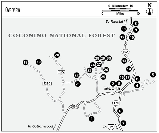
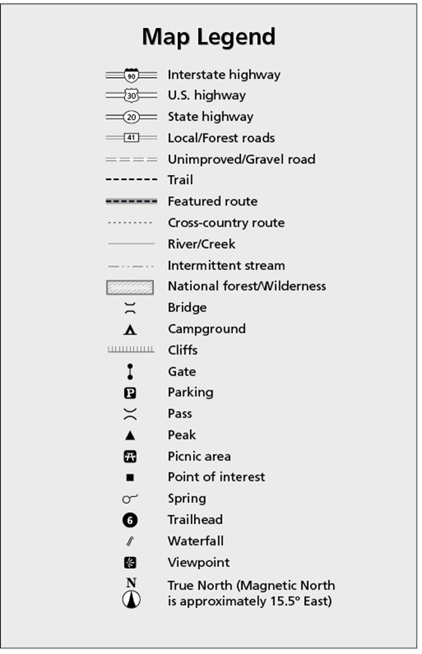
The hikes in this book are easy to follow. The maps provided show each trail, so you wont need to buy extra maps. If you decide to explore farther or go off-trail, however, youll need more detailed maps. All the hikes in this book are covered by the detailed topographic maps published by the U.S. Geological Survey (USGS), which are available through local outdoors shops or by calling (888) ASK-USGS or visiting http://store.usgs.gov.
The entire area is also covered by the Coconino National Forest map, available from the Red Rock Ranger Station and from bookstores and outdoors shops. This map shows the forest-road network and can be useful for finding trailheads and for general orientation.
Another map option is the excellent computer-based coverage of the Flagstaff area found on Topo Arizona, published by National Geographic Maps (3212 Beaver Brook Canyon Road, Evergreen, CO 80439; 800-962-1643; www.natgeomaps.com; e-mail: maps@ngs.org). Remember that although topographic maps show the terrain and other natural features very accurately, they are not updated very often. Many of the trails in this book are not shown correctly, or at all, on the topo maps.
Zero Impact
The Red Rock Country is fragile, despite its rugged appearance. Damage done by humans takes many dozens, even hundreds, of years to disappear. Soils in this high-desert region are thin and easily eroded. Evidence of ignorant and careless recreational use is all too evident along forest roads in the form of litter, trampled vegetation, and massive fire rings. Fortunately, backcountry users are generally better informed and more conscientious than vehicle-based recreationists. Most trail sides reflect this care. Following a few simple guidelines will help you leave the land and the trail as you found it.
Waste
Pack out all garbage and trash. If you can carry it in full, you can carry it out empty. After your hike, dispose of trash at trailhead receptacles, if available, or at a campground, rest area, or other facility. Do not feed wild animals. Human food is very bad for them, and animals that become used to handouts lose their fear of humans and become nuisances that may have to be destroyed.
Human waste must be disposed of carefully or it becomes a health hazard. Select a site at least 100 yards from streams, lakes, springs, and dry washes. Avoid barren, sandy soil, if possible. Dig a small cat-hole about 6 inches down into the organic layer of the soil. (Some people carry a small plastic trowel for this purpose.) When finished, refill the hole, making the site appear as natural as possible. Land managers now recommend that all toilet paper be carried out. Use double zipper-style plastic bags containing a small amount of baking soda to absorb odor.
Stay on the Trail
Dont cut switchbacks or take other shortcuts. This practice erodes trails, increases the cost of trail maintenance, and costs you more energy than staying on the trail. The ground in many areas is fragile. Soil takes a long time to form in meadows and pion-juniper forest, and plants have a tenuous foothold. Avoid walking off-trail in such areas if possible. When traveling cross-country, stay on pine needles, rock, sand, or gravel as much as you can, and spread your group out to avoid creating a new trail. Never blaze trees, construct rock cairns, or build anything else along the trail.


