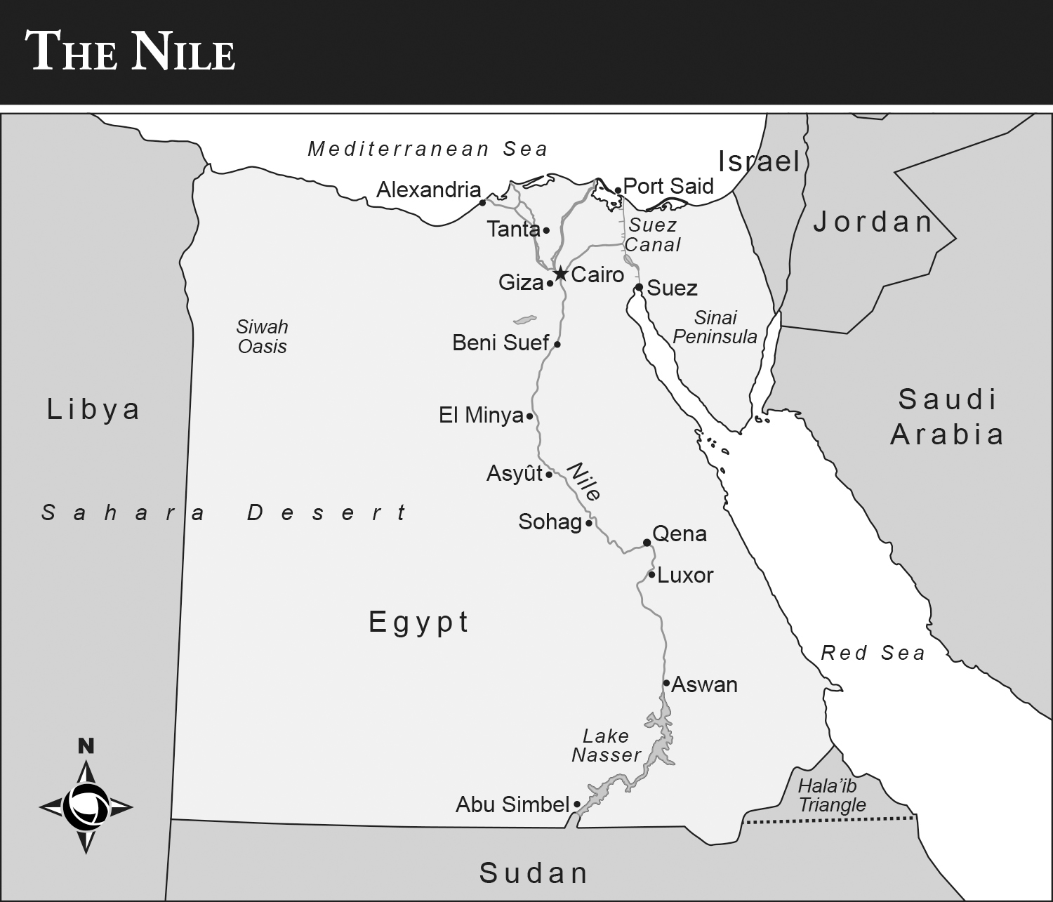
Map of Egypt showing the course of the Nile. Nearly all of Egypts population is crowded into the narrow Nile Valley.
The Nile
An Encyclopedia of Geography, History, and Culture
JOHN A. SHOUP

Copyright 2017 by ABC-CLIO, LLC
All rights reserved. No part of this publication may be reproduced, stored in a retrieval system, or transmitted, in any form or by any means, electronic, mechanical, photocopying, recording, or otherwise, except for the inclusion of brief quotations in a review, without prior permission in writing from the publisher.
Library of Congress Cataloging in Publication Control Number: 2016048705
ISBN: 978-1-4408-4040-1
EISBN: 978-1-4408-4041-8
212019181712345
This book is also available as an eBook.
ABC-CLIO
An Imprint of ABC-CLIO, LLC
ABC-CLIO, LLC
130 Cremona Drive, P.O. Box 1911
Santa Barbara, California 93116-1911
www.abc-clio.com
This book is printed on acid-free paper 
Manufactured in the United States of America
Contents
Preface
The Nile River stretches 4,258 miles (6,853 kilometers) from its mouth on the Mediterranean Sea to its original source, the Kagera River in Burundi. It is the longest river on Earth, although not one with the largest discharge of water by volume. On average, the Niles discharge is only 5,500 square feet (5,100 square meters) per second, making it rank far behind the Amazon and Congo Rivers as well as the MississippiMissouriJefferson system in the United States.
This book describes the Nile and the civilizations that grew up along its banks from Central Africa to the highlands of Ethiopia to the Mediterranean Sea. The book is divided into several sections, beginning with thematic essays that examine key topics and ideas relevant to the Nile, followed by entries covering the geographical features (both natural and human-made such as dams) as well as the peoples and cultures that grew up along the Nile. The final section, excerpts of primary documents, includes translations of ancient Egyptian texts, accounts of explorers, and modern agreements on the use of the Niles water.
The Nile plays an extremely important role in the life of Egypt, being the sole source of freshwater. It was said by Greek historian Herodotus that Egypt is the gift of the Nile, and it is true that Egypt could not exist without the Nile. Through most of Egypt, the Nile flows through a narrow valley of some 12 miles (19 kilometers) in width. The valleys sides are steep cliffs of sandstone, limestone, and granite. The narrow valley made it possible for the formation of a state early in its history, and Upper Egypt unified during the predynastic period (dynasty zero) and was able to impose its control over the delta. It also made Egypt usually inward looking, and it did not move its capital to the Mediterranean coast until the Ptolemaic period.
The last tributary reaches the Nile in Sudan. The Atbara River flows out of the highlands of Ethiopia and joins the Nile north of Khartoum. The Nile then flows through desert until it reaches the delta. The river loses a great deal of water to evaporation, and today it loses much more at Lake Nasser, which was formed by the Aswan High Dam. The Aswan High Dam was built to provide electricity for the countrys modernization and to control the annual Nile flood. The last year of uncontrolled flooding was 1970. Today, the Aswan High Dam holds three years worth of water in Lake Nasser, and water is released to maintain the Nile at a constant level no matter the time of year and no matter whether the floodwaters from Ethiopia were too little in a particular year.
The ancient Egyptians believed that the Nile god, Hapi, lived in a cave under Elephantine Island at Aswan and that the Nile flood began from there. Hapi was depicted as a man with folds of fat and large breasts to indicate the fertility and prosperity the flood brought. Today the controlled flood is a source of great concern because the silt left behind by the floodwaters that made Egypt fertile must be replaced by chemical fertilizers. The Nile delta also faces threats from the Mediterranean Sea and global warming. Lands in the delta have become salt swamps as the Mediterranean begins to penetrate inland. If much of the book seems to have too much emphasis on Egypt, the authors apologize, but as readers will see, the Nile is of prime importance to Egypt today as it has been throughout history.
Acknowledgments
I would like to thank the many people who helped make this book possible. First, I thank my contributors, Geri Shaw and Dr. Connell Monette. Geri and I took the course Geography of Africa from Dr. James King together years ago at the University of Utah, and his class greatly increased my personal interest in Africa and the Nile River. Connell is a colleague at Al Akhawayn University in Ifrane, and we have collaborated on several projects in the past. I would like to thank my deans, Drs. Mohamed Dahbi and now Nizar Messari, for encouraging publications by their faculty members. I feel I need to also thank Dr. Walter Armbrust. It was his invitation to visit him in Cairo that brought me to Egypt for the first time in 1986. This was only one month after the security forces had rioted over low pay and the country was nearly empty of tourists. In 1987, I returned to Egypt for an extended visit (a Nile cruise from Aswan to Luxor on a felucca) and decided I would like to live and work in Egypt. The end result was that I accepted a job at the American University in Cairo, where I was from 1990 to 1996. I had no hesitation about accepting the job offer when it came. I would like to thank Kaitlin Ciarmiello of ABC-CLIO Press for being a constant support during the writing process; although we have collaborated several times, we have yet to meet. I need to thank my parents, John and Nellie (now both deceased), who gave me books such as those by Alan Moorehead, The White Nile and The Blue Nile , that helped fuel my interest in the Nile and the peoples who live along its banks. Finally, I would like to thank my sister Heather and my nieces Gail and Charlotte for their love and support.
Part I
Thematic Essays
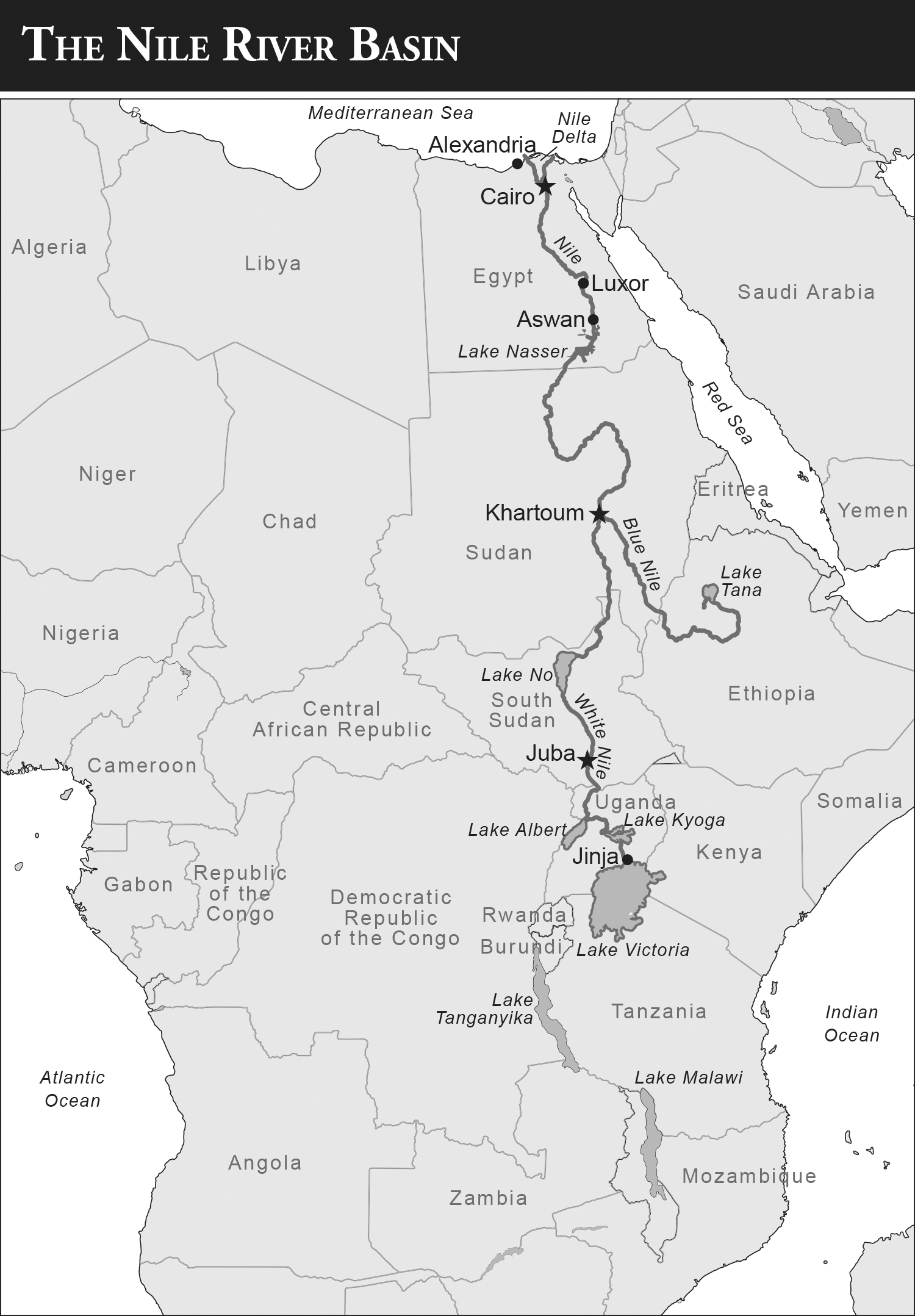
The Nile Basin drains Central Africa and the Horn of Africa. It is separated from the Congo that drains most of Central Africa by a narrow range that marks the western side of the Great Rift Valley.
Geography of the Nile
Like most bodies of water, along its course the Nile River includes many major featureslakes, falls, and rapids or cataracts. The Nile begins in the highlands of Burundi and Rwanda and flows ever northward through several lakes, including Lake Victoria, the largest freshwater lake in Africa, and Lake Edward before it enters the Sudd, the great swamp that blocks much of the water from Central Africa before it emerges as the White Nile and continues on to Khartoum. There the White Nile joins the Blue Nile. Between Khartoum and Aswan, the river goes through five cataracts or rapids that historically held up navigation on the river except during the annual flood.
The Nile has many tributaries, the last being the Atbara River, which joins the Nile north of Khartoum. Most of the major tributaries flow from the highlands of Ethiopia and increase the flow of the Niles annual flood. Now controlled, the Nile has been dammed along its course from nearly its start to Aswan. The Nile was also dammed north of Cairo to put water into canals that helped increase the amount of land under cultivation.
Next page

