All rights on this book are reserved by Harmakis Edizioni
Division of S.E.A. Servizi Editoriali Avanzati,
Registered office - Via Del Mocarini, 11 - 52025 Montevarchi (AR) - Italy
Headquarter the same aforementioned.
www.harmakisedizioni.org
ISBN: 978-88-98301-72-0
Editorial Director: Paola Gnolucci
Layout and graphic processing: Sara Barbagli
INTRODUCTION
KEMET THE BLACK LAND
The Egyptian civilization, which flourished along the banks of the Nile for 3,000 years, was one of the most extraordinary and enduring of the ancient world. Even today, after two thousand years since its setting, it continues to exert considerable charm. The Egyptians have left many traces of their culture, thanks to the dry desert climate that has preserved over the centuries. The Sphinx and many pyramids, mummies, funerary masks, funerary decorations, the papyri are thus been preserved from destruction, the common fate of many ancient remains.
Egypt and in fact also known as the gift of the Nile, because the flooding of the river deposited on the fields a layer of fertile silt, vital for the growth of crops. Already in the prehistoric age, the early inhabitants learned to sow and plant their crops in the fields still covered by mud after the waters had receded. I collected, almost always abundant, allowed that civilization to thrive and achieve a brilliance never known before. The ancient Egyptians called the fertile valley of the Nile kemet, black land, and themselves remet-en-kemet, the people of the black land, while the desert surrounding the town was said deshret, red land.
THE NILE
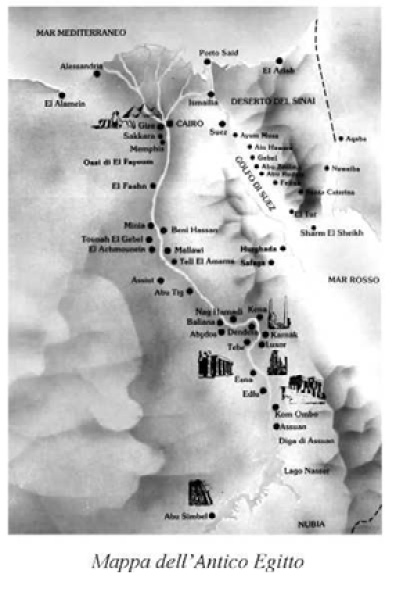
The bond that links Egypt with the Nile, and something symbiotic, this 6671 km long river, which originates in the central and eastern parts of Africa (Sudan). The Nile has two major tributaries: the White Nile and the Blue Nile, which meet and are close to the capital of Sudan, Khartoum. With a capacity of 2,830 cubic meters per second (the annual average and 1,048 cubic meters) and with a catchment area covering an area of 3,254,555 square kilometers (almost 11 times ltaly), which represents about 10% of the surface Africa and one of the most long World River.
In a desert region of Egypt as an oasis wide river from 5 to 20 km can be used for cultivation. North of Cairo, it divides into two branches that flow into the Mediterranean: the Rosetta Branch to the west and the Damietta Branch east that create such a Delta which covers 24,000 square kilometers surface. From Khartoum the Nile and very smooth with very little slope, interrupted only by the six cataracts to Aswan, which are an obstacle to navigation only in shallow waters.
The Nile and was and is still used for the transport of goods along the way. While most Egyptians still live in the Nile valley, the construction of the Aswan Dam to provide hydroelectric power, it stopped the renewal of fertile land by the annual floods and has become one of the causes of the gradual eroding of the wide delta. But it ensures consistently Egypt drinking water, that in the management of the river often runs counter to the needs of other countries, such as Uganda, Sudan, Ethiopia and Kenya. The dam and one of the largest in the world and its construction has created the largest lake Nasser which covers 5250 square kilometers. Other dams were built in Esna, Asyut and Delta.
Until the construction of the Aswan Dam its annual floods made the surrounding land extremely fertile, allowing you to grow grain and other crops. Moreover, the introduction to work of the buffalo Persians in the seventh century BC, who sought humid environment with the presence of water, in addition to camels, it represents an excellent source of meat for the neighboring population. The domesticated buffalo could also be used for plowing, while the camels as pack animals.
Its floods are fairly regular: starting in June they arrive at the maximum capacity at the end of September, after which subside until the following June (the Egyptians had only three seasons data divided into four months each: summer, autumn and winter). This trend of full and caused by complex network of tributaries feeding the river, while the fertilizer substances are carried by Ethiopian streams with the impetuosity of their waters erode the volcanic massifs removing the fertilizer substances.
In the past, because of these floods, the water level increased by several meters (at Aswan of 9 meters), and only the villages built on the heights were not subject to damage. The Nile water left in the fields a large water reservoir as well as a very rich layer of silt fertilizer substances.
All ancient Egyptian tombs were built west of the Nile, because the Egyptians believed that in order to enter the afterlife, was necessary to be buried on the side that symbolized death.
THE VALLEY OF THE KINGS
Kings Valley
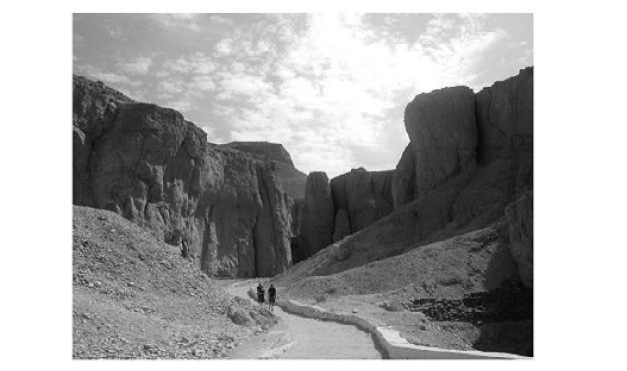
(Biban el-Muluk). Royal necropolis of ancient Thebes (Egypt), located 5 km east of the Nile between rugged desert mountains; It contains 62 tombs of kings and individuals of the highest rank of the XVIII-XX Dynasties (ca. 1550-1069 BC), from that of Thutmose I (KV 38) to Ramesses XI (KV 4). The graves, dug deep into the rock, are composed in their essentiality by an entrance portal, which was hidden by debris, a descending corridor, a vestibule and a sarcophagus chamber. The mortuary temple, where the late King was receiving the same worship reserved for of, it remained accessible to the valley margins. Initially the graves were made of a long, steep curved corridor, which opened into an oval burial chamber and in quadrangular below. The book dellAmduat, a real guide of the underworld, decorated the walls in a linear style, in imitation of the papyrus entered the era. From Horemheb (ca. 1323-1295 BC), the last pharaoh of the eighteenth dynasty, the aisles were enlarged and became upright, leading, among splendid painting in relief decoration, the burial chamber. Religious texts were enriched repertoire and colors, including now the Litany of the Sun, the Earth Book, the Book of Gates and the Book of Caverns.
The ceiling of the burial chamber was decorated with deans and constellations, in a riot of gold on blue sky background. Plundered since the end of the New Kingdom and visit Greek and Roman times, the tombs of the Valley of the Kings have been explored in modern times starting with the Napoleonic expedition (1798-99), to the sensational discovery in 1922, the almost tomb Tutankhamuns intact. At the beginning of 1990 an American expedition led by K. Weeks rediscover in the Valley of the Kings a giant collective tomb (KV 5), the burial place of some male children (there were about 45) of Ramesses II (ca. 1279-1213 BC), the famous pharaoh of the nineteenth dynasty. The monument found and the most extended of the Valley, with over 110 rooms and corridors and a T-shaped structure that recalls the Serapeum of Saqqara, the burial place of the sacred bull Apis their start by Ramesses II. The same K. Weeks, and at the head of the


