E-book published in 2012 by Encyclopdia Britannica, Inc., in association with Arcturus Publishing Limited, 26/27 Bickels Yard, 151-153 Bermondsey Street, London SE1 3HA. Britannica, Encyclopdia Britannica, and the Thistle logo are registered trademarks of Encyclopdia Britannica, Inc.
ISBN 978-1-61535-635-5 (e-book)
This edition first published by Arcturus Publishing
Distributed by Black Rabbit Books
P.O. Box 3263
Mankato
Minnesota MN 56002
Copyright 2008 Arcturus Publishing Limited
Library of Congress Cataloging-in-Publication Data
Barber, Nicola.
Afghanistan / Nicola Barber.
p. cm. -- (Changing world)
1. Afghanistan--Juvenile literature. I. Title.
DS351.5.B36 2009
958.1--dc22
2008016653
The right of Nicola Barber to be identified as the author of this work has been asserted by her in accordance
with the Copyright, Designs and Patents Act 1988.
All rights reserved.
Series concept: Alex Woolf
Editor and picture researcher: Cath Senker
Designer: Ian Winton
Illustrator: Stefan Chabluk
Picture credits:
Corbis: cover left (Adrees Latif/Reuters), cover right (David Trilling), 8 (Natalie Behring-Chisholm/Reuters), 9
(Reza/Webistan), 12 (Alain DeJean/Sygma), 15 (epa), 23 (Reza/Webistan), 29 (Ahmad Masood/Reuters), 30
(Manca Juvan), 32 (Reuters), 38 (Arshad Arbab/epa), 42 (Syed Jan Sabawoon/epa).
EASI-Images (all Jenny Matthews): 14, 16, 17, 18, 19, 20, 21, 24, 26, 28, 31, 33, 34, 37, 40, 41, 43.
Topfoto: 11 (The British Library/HIP), 25 (Topham/Photri), 36.
The illustrations on pages are by Stefan Chabluk.
Cover captions:
Left: A Pashtun boy rides his mule past poppy fields at dusk near the southern city of Qandahar.
Right: Traffic in west Kabul.
Every attempt has been made to clear copyright. Should there be any inadvertent omission, please apply
to the copyright holder for rectification.
Contents
CHAPTER 1
Introduction

I n size, the country of Afghanistan is slightly smaller than Texas. It lies in the heart of Asia and is completely landlocked (enclosed by land). Its longest border is with Pakistan to the east and south. Afghanistan also has borders with Iran to the west and three Central Asian states to the north. It has a very short border with China in the mountainous northeast.
Landlocked and rugged
Roughly three-quarters of Afghanistans landscape is mountainous and rugged. The ranges that dominate the center of the country include the Paropamisus and the Koh-i-Baba mountain ranges. Extending northeast from the Koh-i-Baba are the ranges of the Hindu Kushthe backbone of the country.
The airy peaks of the Hindu Kush include Mount Noshaq, Afghanistans highest mountain (see box). Several high passesroutes that allow people and vehicles to travel through the mountainscross this inhospitable land. The most important of these is the Salang Pass, which connects northern Afghanistan with Kabul to the south. A tunnel constructed in the 1960s cut down the time taken by vehicles to travel across this pass from 72 hours to 10 hours. At an altitude (height) of 11,152 ft (3,400 m), the tunnel is one of the highest in the world.
GEOGRAPHIC FEATURES
Area: 252,330 sq mi (647,500 sq km)
Border countries: China, Iran, Pakistan, Tajikistan, Turkmenistan, Uzbekistan
Coastline: none
Highest mountain: Noshaq, Hindu Kush 24,551 ft (7,485 m)
Major rivers: Amu Darya, Hari, Kabul, Helmand
Major cities: Kabul (capital), Qandahar, Mazar-e-Sharif, Herat
Source: CIA World Factbook, 2008
Plains and plateaus
North of the central mountain ranges lie the northern plains, which border Turkmenistan and Uzbekistan. The Amu Darya and numerous other, smaller rivers bring snowmelt from the Hindu Kush and the central mountain ranges to water fertile foothills and plains. Historically, this region has been a productive agricultural area, but recent conflicts have forced many farmers to flee their farms and pastures.
The southern lowlands have an average altitude of about 2,950 ft (900 m). This area, covering about 50,700 sq mi (130,000 sq km), forms part of the much larger Plateau of Iran, which also extends into Iran and Pakistan. Most of the land in this region is desert or semi-desert, although the Helmand River, which bisects the region, provides some water for irrigation (watering crops).
Climate
Afghanistans location, far from the moderating influence of the sea, means that it has a continental climatewith some of the greatest extremes of temperatures in the world. In the mountainous regions, temperatures can drop as low as 13 F (25 C) in the winter, while on the northern plains, summer temperatures in the daytime can rise as high as 115F (46C). In addition to seasonal extremes, temperatures often rise and fall rapidly between day and night. The Asian monsoon brings rain during the summer months to western Afghanistan, but the deserts of the southern lowlands remain hot and dry all year round.
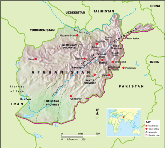
This map shows the major towns and cities of Afghanistan and other places mentioned in this book. It also shows the mountain ranges that dominate a large part of this rugged country. The inset map indicates Afghanistans location in the world.
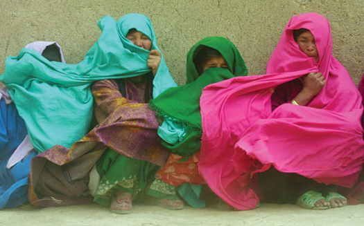
Hazara women in the town of Bamian are caught by a strong gust of wind. The women run a bakery that provides rations of bread to elementary school children. The central region of Afghanistan, where many Hazaras live, is known as Hazarajat.
People
In 2007, the population of Afghanistan was estimated to be 31,889,923. However, exact data for the number of people living in the country have long been unavailable because there has not been a nationwide census (official population count) since 1979. Even the 1979 census was unreliable because of conflict in parts of the country. Plans to hold a census were under way in 2008, backed by the United Nations (UN).
The people of Afghanistan come from a wide variety of ethnic backgrounds and speak many different languages. The majority of Afghans belong to one of two Indo-European ethnic groups, the Pashtuns and the Tajiks. The Pashtuns make up between 36 and 42 percent of the population and live mainly in the south and east. The Tajiks account for between 27 and 33 percent of the population and are found mainly in the northern provinces of Afghanistan. The next-largest ethnic group, the Hazaras, are about 9 percent of the population. They live in the central mountainous regions of the country. In the north are two Turkic groups, the Uzbeks and the Turkmen, who account for roughly 9 and 3 percent of the population respectively. Other minority groups in Afghanistan include the Aimak, the Baloch, the Nuristani, and the Pashai.
CASE STUDY: THE PASHTUNS
The Pashtuns make up the largest ethnic group in Afghanistan, and since the founding of the country in 1747 (see page ), they have traditionally held the balance of power. Every ruler of Afghanistan from 1747 until 1978 was a Pashtun. However, the Pashtuns are themselves divided into tribal groups, with strong loyalties within the groups. Pashtun behavior is governed by an ancient set of laws called Pashtunwali (the way of the Pashtuns), which stresses family honor and vengeance for insults and also personal bravery and generous hospitality.
Next page


