1.1 Introduction
Coastal ecosystems, including marshes, mangroves, seagrasses and coral reefs, are highly productive and act as critical habitats for a wide variety of plants, fish, shellfish, and other wildlife. For instance, coastal wetlands provide flood protection, protection from storm and wave damage, water quality improvement through filtering of agricultural and industrial waste, and recharge of aquifers (Morris et al. ). Furthermore, with events such as the hurricanes of 2004, 2005 and 2012 annual losses to coastal communities can total billions of dollars. Environmental impacts from coastal storms include beach erosion, wetland destruction, excessive nutrient loading, algal blooms, hypoxia and anoxia, fish kills, releases of pollutants, spread of pathogens, and bleaching of coral reefs.
Over the long term, coastal communities are also facing a rising sea level. The substantial sea level rise and more frequent storms predicted for the next 50100 years will affect coastal towns and roads, coastal economic development, beach erosion control strategies, salinity of estuaries and aquifers, coastal drainage and sewage systems, and coastal wetlands and coral reefs (Gesch ).
Since coastal ecosystems have high spatial complexity and temporal variability, they require high spatial, spectral and temporal resolutions. Recent advances in sensor design and data analysis techniques are making remote sensing systems practical and cost-effective for monitoring natural and man-made changes impacting coastal ecosystems. High resolution multispectral and hyperspectral imagers, LiDAR and radar systems are available for monitoring changes in coastal marshes, submerged aquatic vegetation, coral reefs, beach profiles, algal blooms, and concentrations of suspended particles and dissolved substances in coastal waters. Some of the ecosystem health indicators that can be mapped with new high-resolution remote sensors include natural vegetation cover, wetland loss and fragmentation, wetland biomass change, percent of impervious watershed area, buffer degradation, changes in hydrology, water turbidity, chlorophyll concentration, eutrophication level, salinity, etc . (Lathrop et al. ).
With the rapid development of new remote sensors, data bases and image analysis techniques, potential users need guidance in choosing remote sensors and data analysis methods that are most appropriate for each specific coastal application (Yang ). The objective of this paper is to review those remote sensing techniques that are cost-effective and practical for shoreline delineation, wetland mapping and other coastal applications.
1.2 Wetland Mapping
For more than three decades remote sensing techniques have been used by researchers and government agencies to map and monitor wetlands (Dahl ).
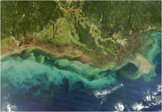
More recently other medium spatial resolution satellite sensors, such as MODIS on NASAs Terra and Aqua satellites, have been used to map wetlands and study their interaction with storm surges. This is illustrated in Fig. ).
Fig. 1.1
The Moderate Resolution Imaging Spectroradiometer (MODIS) on NASAs Terra satellite captured this image on September 26, 2008, 13 days after Hurricane Ike came ashore. The brown areas in the image are the result of a massive storm surge that Ike pushed far inland over Texas and Louisiana causing a major marsh dieback (Color figure online) (Credits: NASA/GSFC)
Many coastal ecosystems are patchy and exhibit considerable variations in their extent, spatial complexity, and temporal variability (Dahl ).
High resolution imagery is more sensitive to within- class spectral variance, making separation of spectrally mixed land cover types more difficult than when using medium resolution imagery. Therefore, pixel-based techniques are sometimes replaced by object-based methods, which incorporate spatial neighborhood properties, by segmenting/partitioning the image into a series of closed objects which coincide with the actual spatial pattern, and then proceed to classify the image. Region growing is among the most commonly used segmentation methods. This procedure starts with the generation of seed points over the whole scene, followed by grouping neighboring pixels into an object under a specific homogeneity criterion. Thus the object keeps growing until its spectral closeness metric exceeds a predefined break-off value (Kelly and Tuxen ).
Small wetland sites are often mapped and studied using airborne sensors (Jensen ).
Digital camera imagery can be integrated with GPS position information and used as layers in a GIS for a wide range of modeling applications (Lyon and McCarthy ).
1.3 Hyperspectral Remote Sensing of Wetlands
Airborne hyperspectral imagers, such as the Advanced Visible Infrared Imaging Spectrometer (AVIRIS) and the Compact Airborne Spectrographic Imager (CASI) have been used for mapping coastal wetlands and shallow water substrate (Fearns et al. ).
The advantages and problems associated with hyperspectral mapping have been clearly demonstrated by Hirano et al. ().
The hyperspectral data proved effective in discriminating spectral differences among major Everglades plants such as red, black and white mangrove communities and enabled the detection of exotic invasive species (Hirano et al. ).
A number of advanced new techniques have been developed for mapping wetlands and even identifying wetland types and plant species (Schmidt et al. ).
Hyperspectral imaging systems are now available not only for airborne applications, but also in space, such as the satellite-borne Hyperion system, which can detect fine differences in spectral reflectance, assisting in species discrimination on a global scale (Christian and Krishnayya ).

