Barbara Sinotte - Connecticut: A Guide to the State Parks & Historic Sites
Here you can read online Barbara Sinotte - Connecticut: A Guide to the State Parks & Historic Sites full text of the book (entire story) in english for free. Download pdf and epub, get meaning, cover and reviews about this ebook. year: 2013, publisher: Hunter, genre: Politics. Description of the work, (preface) as well as reviews are available. Best literature library LitArk.com created for fans of good reading and offers a wide selection of genres:
Romance novel
Science fiction
Adventure
Detective
Science
History
Home and family
Prose
Art
Politics
Computer
Non-fiction
Religion
Business
Children
Humor
Choose a favorite category and find really read worthwhile books. Enjoy immersion in the world of imagination, feel the emotions of the characters or learn something new for yourself, make an fascinating discovery.

- Book:Connecticut: A Guide to the State Parks & Historic Sites
- Author:
- Publisher:Hunter
- Genre:
- Year:2013
- Rating:3 / 5
- Favourites:Add to favourites
- Your mark:
Connecticut: A Guide to the State Parks & Historic Sites: summary, description and annotation
We offer to read an annotation, description, summary or preface (depends on what the author of the book "Connecticut: A Guide to the State Parks & Historic Sites" wrote himself). If you haven't found the necessary information about the book — write in the comments, we will try to find it.
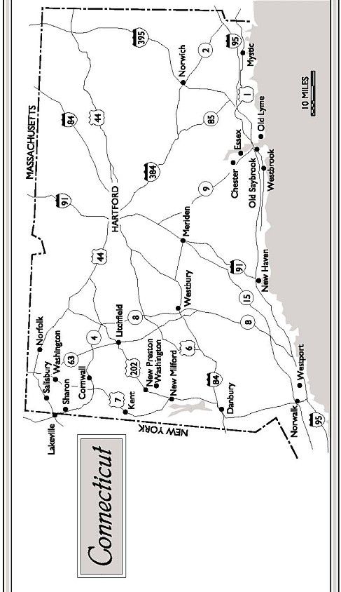
This guide is a must for both visitors and residents who want to enjoy the wide range of recreational opportunities offered here. Connecticut measures 90 miles east to west, 75 miles north to south, with the Connecticut River cutting the state in half. It is rolling and hilly and ever changing. It is tiny, to say the least, but this wonderful state offers some of the best kept parks and forests anywhere and will not disappoint you. Some of the parks are small, but they offer sanctuary for birds and wildlife and even city-weary urban dwellers. Algonquin State Forest, Cockaponset State Forest, Edward Steichen Memorial Wildlife Preserve, Housatonic Meadows State Park, Macedonia Brook State Park, Rocky Neck State Park, Salmon River State Forest, Salt Meadow National Wildlife Refuge these are just a few of close to 40 state parks and forests described in this guide. Then there are the historic sites, from Weir Farm National Historic Site to the Yale University Art Gallery, Florence Griswold Museum to the Connecticut Impressionist Art Trail. This guide will help you find the perfect place for a weekend getaway, active family outing, quiet wilderness retreat almost any type of outdoor experience you desire. Included are nature trails, scenic drives, historic sites, location maps, hiking tips and all the contact information you need.
Barbara Sinotte: author's other books
Who wrote Connecticut: A Guide to the State Parks & Historic Sites? Find out the surname, the name of the author of the book and a list of all author's works by series.

Connecticut: A Guide to the State Parks & Historic Sites — read online for free the complete book (whole text) full work
Below is the text of the book, divided by pages. System saving the place of the last page read, allows you to conveniently read the book "Connecticut: A Guide to the State Parks & Historic Sites" online for free, without having to search again every time where you left off. Put a bookmark, and you can go to the page where you finished reading at any time.
Font size:
Interval:
Bookmark:
Connecticut: A Guide to the State & National Parks
Hiking is by far the most popular activity in state and national parks. Most of the trails are clearly marked. Off-trail travel (commonly referred to as bushwhacking) is practiced by the more adventurous hikers especially in the less-populated areas.
Trails in many state parks have been rated by taking into consideration the length of the hike and the degree of difficulty. If you are not sure which trails are appropriate for you and your family, talk to a park ranger. If you do not exercise regularly, start on beginner trails and increase your distances gradually. Trail maps are usually available either at the trail head or at the ranger station.
While trail signs vary widely, there are a few common markings that everyone should be familiar with. Periodic paint blazes on trees or rocks are clearly the most popular indication of a trail. Plastic markers are often nailed to trees or metal signs or attached to their own wooden posts. Where there are no trees, trails are often marked with piles of rocks.
Watch for trail markers and make a habit of looking for them for your own safety and the safety of those hiking with you. It does not take away from the enjoyment of hiking and will soon become just another natural thing to do.
If you want to go bushwhacking, be careful. Make your first attempts in open areas with limited undergrowth such as a desert area where the terrain is a little easier to tackle. Bushwhacking through areas of dense vegetation is for the more experienced hiker and should only be attempted with map, water, and compass in hand.
Whether you are bushwhacking or following marked trails, set a comfortable pace for yourself. You are not in a race and can better take in the surroundings if you dont rush your excursion. Attempting to go too fast can ruin all the fun and burn you out before you are half-way through your hike. Stumbling or tripping is a clear sign that you may indeed need to slow down.
Remember to take frequent rest stops. Dont wait for fatigue to tell you its time to slow down. A 10- to 15-minute stop every hour or so is a good idea when you begin. After a while, you will know what is best for you.
Dont speed over the rough areas of a trail. Watch out for tree roots and old logs that may be damp and slippery. If you are not sure of your footing, it is wise to crouch just a bit, lowering your center of gravity to reduce the likelihood of falling. Steep trails have caused many hikers to loose their balance and take a tumble. Descending tends to be more hazardous than ascending and requires a little more attention. Hold onto small trees or rocks. When in doubt, sitting and easing your way down on your rear might be the way to go.
It is important to choose a trail that is comfortable for everyone. Younger children should be introduced to hiking with short walks. It is more fun and educational if they can be involved in planning the hike.
Hiking boots
Day pack
Water bottle
Waterproof poncho
Extra sweater
Snack foods
Toilet paper
Plastic litter bag
2 pairs of hiking socks
Liner socks
Long pants
Long-sleeved shirt
Shell parka or windbreaker
In summer you should include:
T-shirt
Shorts
Extra water
Bug repellant
Sunscreen or lotion
Sun hat
In cool or cold weather add:
Additional layers
Cap or hat
Thermal underwear
When hiking without a group of friends add:
Map
Trail guidebook
Compass
First aid kit
Flashligh
Pocket knife
Matches
Watch
Hiking Safety
- Hike with a friend.
- Take plenty of drinking water.
- Let someone at the camp or at home know where you are going and when you plan to return.
- Dont take shortcuts on a switchback trail.
Connecticut measures 90 miles east to west, 75 miles north to south, with the Connecticut River cutting the state in half. It is rolling and hilly and ever changing. It is tiny, to say the least, but this wonderful state offers some of the best kept parks and forests anywhere and will not disappoint you. Some of the parks are only as big as your back yard, but they offer sanctuary for birds and wildlife and even city-weary urban dwellers.
The Department of Environmental Protection maintains all of the states natural resources. For further information contact them at: 165 Capitol Ave., Hartford, CT 06106.
The Office of State Parks and Recreation is responsible for recreation areas in State Parks and State Forests. You can reach them at tel. (203) 566-2304.
Location: From Winsted, head north on SR 8 for 1 miles and follow the signs.
You may wonder why anyone would visit this state forest. It is closed to hunting and has few, if any, respectable fishing streams. There are no trails to speak of. Bushwhacking is the only way to go. But the birds! Its described in Billards Places to Look for Birds as a good place to see warblers in spring and fall. It is a sight to behold, and birdwatchers will have trouble finding a more perfect, unspoiled location.
For further information contact: Office of State Parks and Recreation, 165 Capitol Ave., Hartford, CT 06106. tel. (203) 566-2304.
Location: From I-95, Exit 88 to Route 117 S.
The Reserve is a bluff overlooking Mumford Cove, Long Island Sound, and the Poquonock River. The wooded highland descends to tidal wetlands. A long, narrow sandspit curves westward, ending at Bushy Point, a small island.
For further information contact: Office of State Parks and Recreation, 165 Capitol Ave., Hartford, CT 06106. tel. (203) 566-2304.
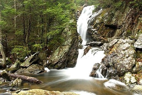
Location: On the Connecticut/Massachusetts border off Route 272 N.
A short trail through a delightful hemlock forest leads right into Massachusetts at Campbell State Park. The 50-ft. falls on Ginger Creek drop into a narrow ravine.
For further information contact: Office of State Parks and Recreation, 165 Capitol Ave., Hartford, CT 06106. tel. (203) 566-2304.
Location: From I-95 at Clinton, exit 63 N or SR 81 to Killingsworth.
This small park adjoins part of the Cockaponset State Forest and offers 18 miles of hiking trails, including the blue-blazed Chatfield Trail. A seven-acre pond provides fishing and swimming.
For further information contact: Office of State Parks and Recreation, 165 Capitol Ave., Hartford, CT 06106. tel. (203) 566-2304.
Location: From Chester, 3 miles west on SR 148.
The states second largest State Forest extends for about 10 miles north to south on both sides of SR 9 in the western Connecticut River Valley.
Camping: 25 sites.
Hiking: The blue-blazed Cockaponset Trail runs north to south in the Turkey Hill block.
Hunting: Grouse, cottontail, deer, squirrel, raccoon, and waterfowl.
Fishing: Trout fishing.
Ski touring: Trails and unplowed roads.
For further information contact: Office of State Parks and Recreation, 165 Capitol Ave., Hartford, CT 06106. tel. (203) 566-2304.
Font size:
Interval:
Bookmark:
Similar books «Connecticut: A Guide to the State Parks & Historic Sites»
Look at similar books to Connecticut: A Guide to the State Parks & Historic Sites. We have selected literature similar in name and meaning in the hope of providing readers with more options to find new, interesting, not yet read works.
Discussion, reviews of the book Connecticut: A Guide to the State Parks & Historic Sites and just readers' own opinions. Leave your comments, write what you think about the work, its meaning or the main characters. Specify what exactly you liked and what you didn't like, and why you think so.