Unknown - CIA World Factbook 2011
Here you can read online Unknown - CIA World Factbook 2011 full text of the book (entire story) in english for free. Download pdf and epub, get meaning, cover and reviews about this ebook. year: 2011, publisher: Central Intelligence Agency, genre: Politics. Description of the work, (preface) as well as reviews are available. Best literature library LitArk.com created for fans of good reading and offers a wide selection of genres:
Romance novel
Science fiction
Adventure
Detective
Science
History
Home and family
Prose
Art
Politics
Computer
Non-fiction
Religion
Business
Children
Humor
Choose a favorite category and find really read worthwhile books. Enjoy immersion in the world of imagination, feel the emotions of the characters or learn something new for yourself, make an fascinating discovery.
CIA World Factbook 2011: summary, description and annotation
We offer to read an annotation, description, summary or preface (depends on what the author of the book "CIA World Factbook 2011" wrote himself). If you haven't found the necessary information about the book — write in the comments, we will try to find it.
Unknown: author's other books
Who wrote CIA World Factbook 2011? Find out the surname, the name of the author of the book and a list of all author's works by series.


CIA World Factbook 2011 — read online for free the complete book (whole text) full work
Below is the text of the book, divided by pages. System saving the place of the last page read, allows you to conveniently read the book "CIA World Factbook 2011" online for free, without having to search again every time where you left off. Put a bookmark, and you can go to the page where you finished reading at any time.
Font size:
Interval:
Bookmark:
European Union entry follows Taiwan
Taiwan entry follows Zimbabwe
 (map)
(map) Introduction :: Background: Globally, the 20th century was marked by: (a) two devastating world wars; (b) the Great Depression of the 1930s; (c) the end of vast colonial empires; (d) rapid advances in science and technology, from the first airplane flight at Kitty Hawk, North Carolina (US) to the landing on the moon; (e) the Cold War between the Western alliance and the Warsaw Pact nations; (f) a sharp rise in living standards in North America, Europe, and Japan; (g) increased concerns about the environment, including loss of forests, shortages of energy and water, the decline in biological diversity, and air pollution; (h) the onset of the AIDS epidemic; and (i) the ultimate emergence of the US as the only world superpower. The planet's population continues to explode: from 1 billion in 1820, to 2 billion in 1930, 3 billion in 1960, 4 billion in 1974, 5 billion in 1988, and 6 billion in 2000. For the 21st century, the continued exponential growth in science and technology raises both hopes (e.g., advances in medicine) and fears (e.g., development of even more lethal weapons of war).
Geography :: Geographic overview: The surface of the earth is approximately 70.9% water and 29.1% land. The former portion is divided into large water bodies termed oceans. The World Factbook recognizes and describes five oceans, which are in decreasing order of size: the Pacific Ocean, Atlantic Ocean, Indian Ocean, Southern Ocean, and Arctic Ocean.
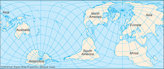
The land portion is generally divided into several, large, discrete landmasses termed continents. Depending on the convention used, the number of continents can vary from five to seven. The most common classification recognizes seven, which are (from largest to smallest): Asia, Africa, North America, South America, Antarctica, Europe, and Australia. Asia and Europe are sometimes lumped together into a Eurasian continent resulting in six continents. Alternatively, North and South America are sometimes grouped as simply the Americas, resulting in a continent total of six (or five, if the Eurasia designation is used). North America is commonly understood to include the island of Greenland, the isles of the Caribbean, and to extend south all the way to the Isthmus of Panama.
The easternmost extent of Europe is generally defined as being the Ural Mountains and the Ural River; on the southeast the Caspian Sea; and on the south the Caucasus Mountains, the Black Sea, and the Mediterranean. Portions of Azerbaijan, Georgia, Kazakhstan, Russia, and Turkey fall within both Europe and Asia, but in every instance the larger section is in Asia. These countries are considered part of both continents. Armenia and Cyprus, which lie completely in Western Asia, are geopolitically European countries. Asia usually incorporates all the islands of the Philippines, Malaysia, and Indonesia. The islands of the Pacific are often lumped with Australia into a "land mass" termed Oceania or Australasia.
Africa's northeast extremity is frequently delimited at the Isthmus of Suez, but for geopolitical purposes, the Egyptian Sinai Peninsula is often included as part of Africa. Although the above groupings are the most common, different continental dispositions are recognized or taught in certain parts of the world, with some arrangements more heavily based on cultural spheres rather than physical geographic considerations. Map references: Political Map of the World , Physical Map of the World , Standard Time Zones of the World  total: 510.072 million sq km country comparison for the world land: 148.94 million sq km water: 361.132 million sq km note: 70.9% of the world's surface is water, 29.1% is land Area - comparative: land area about 16 times the size of the US top fifteen World Factbook entities ranked by size: Pacific Ocean 155.557 million sq km; Atlantic Ocean 76.762 million sq km; Indian Ocean 68.556 million sq km; Southern Ocean 20.327 million sq km; Russia 17,098,242 sq km; Arctic Ocean 14.056 million sq km; Antarctica 14 million sq km; Canada 9,984,670 sq km; United States 9,826,675 sq km; China 9,596,961 sq km; Brazil 8,514,877 sq km; Australia 7,741,220 sq km; European Union 4,324,782 sq km; India 3,287,263 sq km; Argentina 2,780,400 sq km top ten largest islands: Greenland 2,166,086 sq km; New Guinea (Indonesia, Papua New Guinea) 785,753 sq km; Borneo (Brunei, Indonesia, Malaysia) 751,929 sq km; Madagascar 587,713 sq km; Baffin Island (Canada) 507,451 sq km; Sumatra (Indonesia) 472,784 sq km; Honshu (Japan) 227,963 sq km; Victoria Island (Canada) 217,291 sq km; Great Britain (United Kingdom) 209,331 sq km; Ellesmere Island (Canada) 196,236 sq km Land boundaries: the land boundaries in the world total 251,060 km (not counting shared boundaries twice); two nations, China and Russia, each border 14 other countries note: 45 nations and other areas are landlocked, these include: Afghanistan, Andorra, Armenia, Austria, Azerbaijan, Belarus, Bhutan, Bolivia, Botswana, Burkina Faso, Burundi, Central African Republic, Chad, Czech Republic, Ethiopia, Holy See (Vatican City), Hungary, Kazakhstan, Kosovo, Kyrgyzstan, Laos, Lesotho, Liechtenstein, Luxembourg, Macedonia, Malawi, Mali, Moldova, Mongolia, Nepal, Niger, Paraguay, Rwanda, San Marino, Serbia, Slovakia, Swaziland, Switzerland, Tajikistan, Turkmenistan, Uganda, Uzbekistan, West Bank, Zambia, Zimbabwe; two of these, Liechtenstein and Uzbekistan, are doubly landlocked Coastline: 356,000 km note: 95 nations and other entities are islands that border no other countries, they include: American Samoa, Anguilla, Antigua and Barbuda, Aruba, Ashmore and Cartier Islands, The Bahamas, Bahrain, Baker Island, Barbados, Bermuda, Bouvet Island, British Indian Ocean Territory, British Virgin Islands, Cape Verde, Cayman Islands, Christmas Island, Clipperton Island, Cocos (Keeling) Islands, Comoros, Cook Islands, Coral Sea Islands, Cuba, Curacao, Cyprus, Dominica, Falkland Islands (Islas Malvinas), Faroe Islands, Fiji, French Polynesia, French Southern and Antarctic Lands, Greenland, Grenada, Guam, Guernsey, Heard Island and McDonald Islands, Howland Island, Iceland, Isle of Man, Jamaica, Jan Mayen, Japan, Jarvis Island, Jersey, Johnston Atoll, Kingman Reef, Kiribati, Madagascar, Maldives, Malta, Marshall Islands, Martinique, Mauritius, Mayotte, Federated States of Micronesia, Midway Islands, Montserrat, Nauru, Navassa Island, New Caledonia, New Zealand, Niue, Norfolk Island, Northern Mariana Islands, Palau, Palmyra Atoll, Paracel Islands, Philippines, Pitcairn Islands, Puerto Rico, Reunion, Saint Barthelemy, Saint Helena, Saint Kitts and Nevis, Saint Lucia, Saint Pierre and Miquelon, Saint Vincent and the Grenadines, Samoa, Sao Tome and Principe, Seychelles, Singapore, Solomon Islands, South Georgia and the South Sandwich Islands, Spratly Islands, Sri Lanka, Svalbard, Tokelau, Tonga, Trinidad and Tobago, Turks and Caicos Islands, Tuvalu, Vanuatu, Virgin Islands, Wake Island, Wallis and Futuna, Taiwan Maritime claims: a variety of situations exist, but in general, most countries make the following claims measured from the mean low-tide baseline as described in the 1982 UN Convention on the Law of the Sea: territorial sea - 12 nm, contiguous zone - 24 nm, and exclusive economic zone - 200 nm; additional zones provide for exploitation of continental shelf resources and an exclusive fishing zone; boundary situations with neighboring states prevent many countries from extending their fishing or economic zones to a full 200 nm Climate: Current Weather a wide equatorial band of hot and humid tropical climates - bordered north and south by subtropical temperate zones - that separate two large areas of cold and dry polar climates Terrain: the greatest ocean depth is the Mariana Trench at 10,924 m in the Pacific Ocean Elevation extremes: lowest point: Bentley Subglacial Trench -2,555 m note: in the oceanic realm, Challenger Deep in the Mariana Trench is the lowest point, lying -10,924 m below the surface of the Pacific Ocean highest point: Mount Everest 8,850 m top ten highest mountains (measured from sea level): Mount Everest (Nepal-China) 8,850 m; K2 (Pakistan) 8,611 m; Kanchenjunga (Nepal-India) 8,598 m; Lhotse (Nepal) 8,516 m; Makalu (Nepal-China) 8,463 m; Cho Oyu (Nepal-China) 8,201 m; Dhaulagiri (Nepal) 8,167 m; Manaslu (Nepal) 8,163 m; Nanga Parbat (Pakistan) 8,125 m; Anapurna (Nepal) 8,091 m Natural resources: the rapid depletion of nonrenewable mineral resources, the depletion of forest areas and wetlands, the extinction of animal and plant species, and the deterioration in air and water quality (especially in some countries of Eastern Europe, the former USSR, and China) pose serious long-term problems that governments and peoples are only beginning to address Land use: arable land: 10.57% permanent crops: 1.04% other: 88.39% (2005) Irrigated land: 2,770,980 sq km (2003) Natural hazards: large areas subject to severe weather (tropical cyclones); natural disasters (earthquakes, landslides, tsunamis, volcanic eruptions) volcanism: the world is home to more than 1,500 potentially active volcanoes, with over 500 of these having erupted in historical times; an estimated 500 million people live near these volcanoes; associated dangers include lava flows, lahars (mudflows), pyroclastic flows, ash clouds, ash fall, ballistic projectiles, gas emissions, landslides, earthquakes, and tsunamis; in the 1990s, the International Association of Volcanology and Chemistry of the Earth's Interior, created a list of 16 volcanoes worthy of special study because of their great potential for destruction: Avachinsky-Koryaksky (Russia), Colima (Mexico), Etna (Italy), Galeras (Colombia), Mauna Loa (United States), Merapi (Indonesia), Nyiragongo (Democratic Republic of the Congo), Rainier (United States), Sakurajima (Japan), Santa Maria (Guatemala), Santorini (Greece), Taal (Philippines), Teide (Spain), Ulawun (Papua New Guinea), Unzen (Japan), Vesuvius (Italy) Environment - current issues: large areas subject to overpopulation, industrial disasters, pollution (air, water, acid rain, toxic substances), loss of vegetation (overgrazing, deforestation, desertification), loss of wildlife, soil degradation, soil depletion, erosion; global warming becoming a greater concern Geography - note: the world is now thought to be about 4.55 billion years old, just about one-third of the 13.7-billion-year age estimated for the universe
Font size:
Interval:
Bookmark:
Similar books «CIA World Factbook 2011»
Look at similar books to CIA World Factbook 2011. We have selected literature similar in name and meaning in the hope of providing readers with more options to find new, interesting, not yet read works.
Discussion, reviews of the book CIA World Factbook 2011 and just readers' own opinions. Leave your comments, write what you think about the work, its meaning or the main characters. Specify what exactly you liked and what you didn't like, and why you think so.