CONTENTS
THE CALL
OF THE CAM
C ambridgeshire is a county of waterways, natural and man-made, creating a blue-veined jigsaw of rich greens under wide blue skies. All have their attractions, but none is as lovely, or more varied, than the Cam itself. The river winds through a gently undulating valley and farmlands, past the pinnacled, architectural glories of the city of colleges, and out into the vast flat fields of the peat-rich Fens.
There are, in fact, three rivers feeding the Cam, the Rhee flowing in past Barrington and Haslingfield from the west, the Granta flowing in through Linton and the Abingtons from the east, and the central Cam, born in Essex and flowing south to north. The Cam slides under the M11 to wriggle past the first Cambridgeshire villages of Ickleton and Hinxton.
All along the valley there are traces of Saxon, Roman, and even Neolithic occupation. The river has been fished and the land hunted and then farmed for thousands of years. Today the villages are peaceful and idyllic. Hinxton is small but delightfully photogenic. The thatched Church Green Cottages on the corner of the green contribute to a classic scene which includes the silver-spired church of St Mary and St John. Down by the river is the old white-boarded watermill, which is still opened on Sunday afternoons in the summer.
To go on to Duxford the narrow lane crosses the river by a shallow but fast-flowing ford. To most people Duxford means the magnificent Aviation Museum on the other side of the M11, but the village itself is well worth a visit. Again, the core of the old village is a charming little green, in sight of another church dedicated to St John, shaded by trees and surrounded by old cottages, some thatched and some tiled. There is another restored mill here, about a score of the ancient buildings are listed, and there are two or three lovely old pubs, including the thatched John Barleycorn, which had the date 1660 inscribed on its gable end.
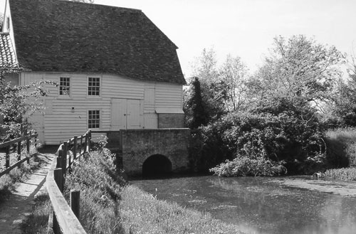
The old watermill at Hinxton.
Duxford is divided by the A505, and on the far side of the road is the magnificently rambling black and white timbered Red Lion pub. Tucked in close beside it is Duxford Chapel, a single hall of flint cobbled walls with a high pitched roof of small red tiles. Inside it is now bare, with a white dirt floor and an impressive high-timbered roof. It was last used as a barn, but it is in fact a rare survival of a mediaeval hospital chapel run by the Knights Templars. It offered shelter to poor travellers and tended to the sick. Its running costs were paid by revenues from a nearby watermill, and from tolls imposed for crossing the ancient Whittlesford Bridge.
From here tiny Whittlesford lies on the east bank of the river, and larger Sawston on the western side. At the heart of Sawston lies the parish church of St Mary, parts of it dating back to Norman times. The church nestles close beside Sawston Hall, which is encircled by a flint wall and hidden deep behind chestnut and plane trees. There is history here, for in 1542 Queen Mary stayed here while still a princess, but was forced to flee from a hostile Protestant mob. The story goes that she left the hall disguised as a dairymaid, protected by the halls owner John Huddleston. The hall was set alight and burned down behind them. The Tudor mansion that was later built on the site is now the Cambridge School for Languages.
Great Shelford is the next large rambling village, with the A1301 slicing brutally through it. West of the road the Cam continues its winding way, between Great and Little Shelford, the latter a smaller gem with lots of lovely old cottages and the beautiful All Saints church. Where the road loops over the bridge between the villages the river flows cool and green through archways of leafy trees.
Just east of Great Shelford and within sight of the southern environs of Cambridge are the Gog Magog hills, a low range of chalk hills which have now become a public park and a golf course. One legend says that Gogmagog was one of a race of 12ft-high giants who inhabited this region in prehistoric times.
Round about 250 BC there was a wave of invasion from France which caused the local population to build a great earthwork fort here with double barrier defences of ditches and stout timber palisades. The fort was called Wandlebury and it was stormed by the invaders. They came in chariots and it was possibly the first time that this new form of warfare had been seen in this part of the world. The new arrivals were the ancestors of the Iceni who later rebuilt the defences against the Romans, which proved another failed effort to hold back the tides of history. Some of the old half-mile circumference of ditches survives as the Wandlebury Ring.
After the fort had disappeared the land was used for grazing sheep. During the reign of James II horse-racing stables were built within the ring by the 2nd Earl of Godolphin. The stable block still remains with a notable cupola clock tower. Godolphin also built his home here and created a park for his own pleasure. The house has vanished but the park remains, now under the care of the Cambridgeshire Preservation Society. Three nature trails have been established with over 200 species of wildflower, a wide variety of bird life and the possibility of glimpsing a fox, a vole or even a muntjac deer.
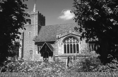
All Saints church at Little Shelford, another Cam Valley jewel.
The main road crosses the Cam again at Grantchester with more access points down to the river. Just before the bridge here there is a signed footpath to Byrons Pool, a walk on a wide footpath through ivy-wreathed woods which comes out on a small weir where the river flows fast. Here the Rhee comes in from the far side to join the Cam. A short walk further up the riverbank and there is a slow cool bend, overhung with willows. This is where Byron, and a whole host of other poets, Brooke, Chaucer, Spenser and Milton, are all believed to have sat to contemplate their muse. A thoughtfully placed seat now allows modern poets to seek their inspiration without suffering the chill of the damp riverbank.
Grantchester is of course the best known of all the Cam Valley villages, being so close to Cambridge and a favourite haunt of tutors and undergraduates alike. It is another delight of thatched roofs and timbered buildings, of pastel-coloured plaster, and good ancient pubs. The Red Lion is painted rust red with high gables and a splendid array of thatched roofs and window overhangs. Beside it there is access to the Cam again, where picnickers lay on the sun-warmed grass, and the punts from Cambridge pole up to enjoy the lazy summer afternoons.
From Grantchester you can follow the footpath along the riverbank into Cambridge, where the river winds through the heart of the city on its spectacular way through the backs of the colleges. Here the punts pole back and forth in idyllic profusion whenever the weather is warm, filled with lounging students and visitors, and creating magical pictures of an elect, youthful paradise under a series of splendid bridges.
The Mathematical Bridge looks like a rustic timber jigsaw. It was designed by a mathematician named William Etheridge in 1749 and was constructed without the use of any form of nails. No one could work out how it was done so at the beginning of this century it was dismantled in an effort to find out. Those who took it apart were still baffled and had to resort to using nails to put it together again. This is the story the tour guides tell but other sources claim that the bridge was always secured by nuts and bolts. The idea of the ghost of old William Etheridge laughing at the baffled confusion of his successors is apparently a pleasing fiction.

