RETRO CLASSICS
is a collection of facsimile reproductions
of popular titles from the 1980s and 1990s
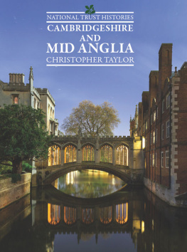
National Trust Histories: Cambridgeshire & Mid Anglia
was first published in 1984
by William Collins & Co Ltd.
Re-issued in 2015 as a Retro Classic
by G2 Rights
in association with Lennard Publishing
Windmill Cottage
Mackerye End
Harpenden
Hertfordshire
AL5 5DR
Copyright 1984 Christopher Taylor and Lennard Books Ltd
ISBN 978-1-78281-146-6
Editor: Michael Leitch
Designed by David Pocknells Company Ltd
Printed and bound by Lightning Source
This book is a facsimile reproduction of Cambridgeshire & Mid Anglia
as it was originally published in 1984.
No attempt has been made to alter any of the wording
with the benefit of hindsight, or to update the book in any way.
C ONTENTS
Character of the region;
Its geological history.
Stone Age hunters and early farmers;
Burial mounds of the Bronze Age people;
Iron Age forts, farmsteads and villages;
The Saxon takeover;
Villages expand in the Norman period;
Effects of the Black Death;
E DITORS INTRODUCTION
Earlier in this century, geographers devoted much time to attempts to draw boundaries around geographical regions. Their failure reminds us of the impossibility of drawing sharp lines around areas which gradually merge into their neighbours. Our Mid Anglia comprises the new counties of Bedfordshire, Cambridgeshire and Northamptonshire. It does not proclaim its personality with great insistence, so that it is only when we realize that this region includes Northamptonshire, with the best assemblage of Saxon churches that any county can boast, the college buildings of Cambridge, and many fine post-medieval buildings such as Wimpole Hall and Kirby Hall that we begin to see it as a particularly fascinating part of England.
Geography and history provide several common denominators within the region. Rather than split Cambridgeshire in half we have included the Fens and Isle of Ely as part of Mid Anglia, while recognizing that their links with Cambridge are balanced by other strong ties with East Anglia, the subject of a future volume.
In the past as still today, Mid Anglia was a prosperous region with much valuable farmland. This prosperity helped to provide an exceptional legacy of fine stone churches and imposing houses. Most of the churches and houses still survive, along with a good legacy of vernacular buildings of a lower order. Sadly, much of the lovely, mature countryside in which these buildings stood has been lost to destructive modern farming methods. Some attractive countryside remains, and here the reader can discover the successive ages of farming which forged these rural vistas.
Christopher Taylor, the author, is a Principal Investigator for the Royal Commission on Historical Monuments and I doubt that anyone has ever known Mid Anglia as well as he does, for in the course of producing the various RCHM volumes on Cambridgeshire and Northamptonshire he explored every nook and cranny of those counties; he has also conducted many archaeological surveys in Bedfordshire. He has tutored and encouraged scores of archaeologists and amateur enthusiasts; taught me far more about the history of the landscape than any other expert, and it is interesting to see how his once-provocative ideas about the achievements and contributions of ancient and medieval people have now become part of mainstream archaeological thinking. Christopher Taylor is the author of several books on the history of our landscape, including volumes on Dorset and Cambridgeshire in the Making of the English Landscape series, Roads and Tracks of Britain and Fields in the English Landscape, while the fascinating results of his long research into the history and layout of English settlement were recently published in the highly praised Village and Farmstead.
Richard Muir
Great Shelford, 1983
O RIGINS
There is no familiar name attaching to that part of England which covers the modern counties of Bedfordshire, Cambridgeshire and Northamptonshire. The term Mid Anglia is perhaps reasonable, in that the ancient Saxon kingdom of the Middle Angles certainly included most of the region under discussion.
The area is not the best-known part of England although Cambridge is a major tourist centre and Ely, with its beautiful cathedral, is also celebrated. There is no majestic scenery, no mountains, no roaring streams, but instead rolling hills, broad rivers and flat fenland. This is a region that is often traversed by visitors going elsewhere. Most of the main arteries of Britain, the A1, A5 and M1, and both East and West Coast main railway lines all cross it. The majority of its historic towns are now by-passed, and the main railway towns, such as Northampton, Bedford and Peterborough, hardly inspire the casual traveller to stop. Yet the region has much to offer both visitor and resident once their interest is aroused. Within it lies the richest farming land in England, where people have toiled for millennia to produce landscapes of considerable beauty and great interest.
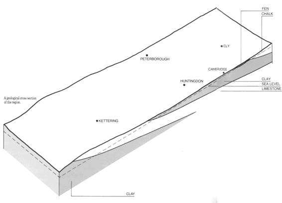
The lack of high land and the gently undulating terrain are the results of geological events that took place in the very remote past, long before the appearance of man. All the underlying rocks in the area are relatively soft and easily worn away by rain and rivers. Chalk, clay, sandstone and limestone predominate. All were laid down millions of years ago in the waters of shallow seas which then covered the region. Between each period of inundation by water the sea floor was uplifted and tilted slightly to the south-east. As a result, the whole area slopes in a general way from north-west to south-east; the oldest rocks lie in the west, and the youngest in the east. This process of deposition and tilting took place over a period of some sixty million years.
By about two million years ago, the general appearance of Mid Anglia had been fixed. Since then, two major processes have added the final details to the landscape. The first occurred in the Great Ice Age, or rather a whole series of Ice Ages, when the land was either covered by very thick sheets of ice or was torn apart by frost action and the work of huge rivers flowing in from the nearby ice. The result was a general smoothing and levelling of the soft rocks; the establishment of the great rivers of the Ouse and the Nene in their broad valleys, and, soon afterwards, the clothing of the landscape by vegetation.
The second was the formation of the Eastern Fens. The ice left behind a great basin in the east of Mid Anglia which became a battleground between the sea and the inland rivers whose waters met and mixed there. In the south of the fens, the rivers, though restrained by the sea, won the battle and their waters spread and created vast lagoons and marshes which became the peat fens. In the north, victory went to the sea which deposited great tracts of marine mud, now forming the northern silt fens. Eventually, the sea retreated and the land emerged as the great flat fenland expanses.
Although these fens are now largely cultivated farmland indeed, the most valuable agricultural land in Britain a few traces of the ancient undrained fens still endure. The best site to visit is Wicken Fen, north-east of Cambridge, which is in National Trust care. Here, not only the natural vegetation of flat fenland but also its myriad animal and bird life have been miraculously preserved and are now carefully managed to give a remarkable insight into the world before man.
Next page
