2013 John L. Sorenson.
All rights reserved. No part of this book may be reproduced in any form or by any means without permission in writing from the publisher, Deseret Book Company (permissions@deseretbook.com), P.O. Box 30178, Salt Lake City Utah 84130. This work is not an official publication of The Church of Jesus Christ of Latter-day Saints. The views expressed herein are the responsibility of the author and do not necessarily represent the position of the Church or of Deseret Book. Deseret Book is a registered trademark of Deseret Book Company.
The publication of Mormons Codex was made possible by generous gifts to the Neal A. Maxwell Institute for Religious Scholarship from many dedicated supporters, including Brad and Ann Botteron, Rondell B. and Joyce P. Hanson, Thomas A. and Cheryl J. Quinn, James E. and Margaret Smith, Lowell and Colleen Sherratt, and Vernon R. and Loretta Rice.
Library of Congress Cataloging-in-Publication Data
Sorenson, John L., author.
Mormons codex : an ancient American book / John L. Sorenson.
pages cm
Includes bibliographical references and index.
ISBN 978-1-60907-399-2 (hardbound : alk. paper)
1. Book of MormonEvidences, authority, etc. 2. Book of MormonGeography. 3. Indians of Central America. I. Title.
BX8627.S6458 2013
289.3'22dc232013006467
Printed in the United States of America
Publishers Printing, Salt Lake City, UT
10 9 8 7 6 5 4 3 2 1
Table of Contents
Orientation
Correspondences by Topic
Correspondences from Archaeology and History
Maps
Map 1. Mormons map of Book of Mormon lands according to the text
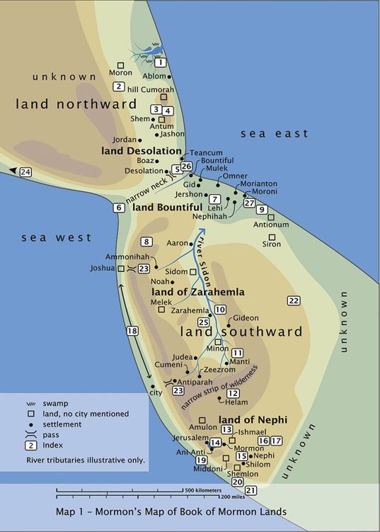
Visit http://bit.ly/182JGlE for a high-resolution image.
"Mormon's Map" shows the most plausible arrangement of Nephite and Lamanite geographical features based on all the information in the record of Mormon and his son Moroni. (Capitalization of names follows the practice of the published text of the Book of Mormon.)
Legend for Map 1
1. waters of Ripliancum
2. limit of Nephite final retreat
3. Shiz's death; plates left
4. hill Shim
5. narrow pass or passage
6. Hagoth's shipbuilding site
7. Moroni's camp
8. Nephites' refuge between the land Bountiful and the land of Zarahemla (see 3 Nephi 3:23, 25)
9. hill Onidah
10. hill Amnihu
11. hill Riplah
12. valley of Alma
13. dispersal point of the sons of Mosiah
14. waters of Mormon
15. hill north of Shilom
16. mount Antipas
17. place Onidah
18. wilderness on the west of the land of Zarahemla
19. wilderness on the west in the land of Nephi
20. Lamanite king's land
21. land of first inheritance
22. wilderness (see Alma 43:22)
23. mountain pass
24. Hagoth's possible destination
25. wilderness of Hermounts
26. "line" between Desolation and Bountiful
27. defense "line"
Map 2. Some Mesoamerican archaeological sites mentioned
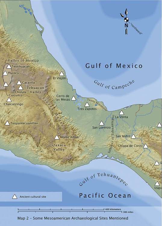
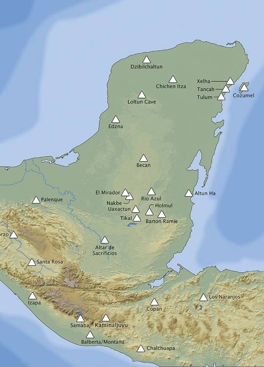
Visit http://bit.ly/15tmmKP for a high-resolution image.
Map 3. Mormons map showing geographical correspondences
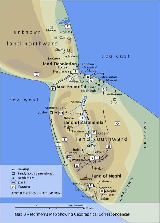
Visit http://bit.ly/170U4uT for a high-resolution image.
Legend for Map 3
A A consistently defensible line; probably river
B A "narrow pass that led by the sea into the land northward"
C No good land passage northward
D The city of Zarahemla, "in the heart of our country"
E The city of Nephi (or Lehi-Nephi)
F Waters of Ripliancum
G Waters of Mormon
H Hagoth's shipbuilding site
J West sea coast
K The arrival point of the Mulekites; city of Mulek
L The cordilleran mountain chain
M1 Mountain pass
M2 Mountain pass
N The "most capital parts" of the land (Hel. 1:27)
P Hill Amnihu
Q East wilderness
R The "borders by the east sea"
S "Narrow strip of wilderness"
T The headwaters of the river Sidon
U Nephite-Lamanite interaction zone
Map 4. Mesoamerican geographical correspondences to Mormons map
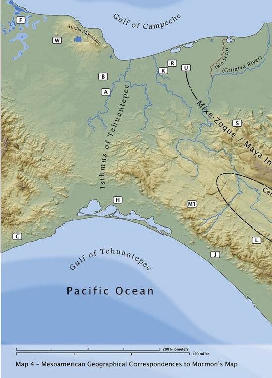
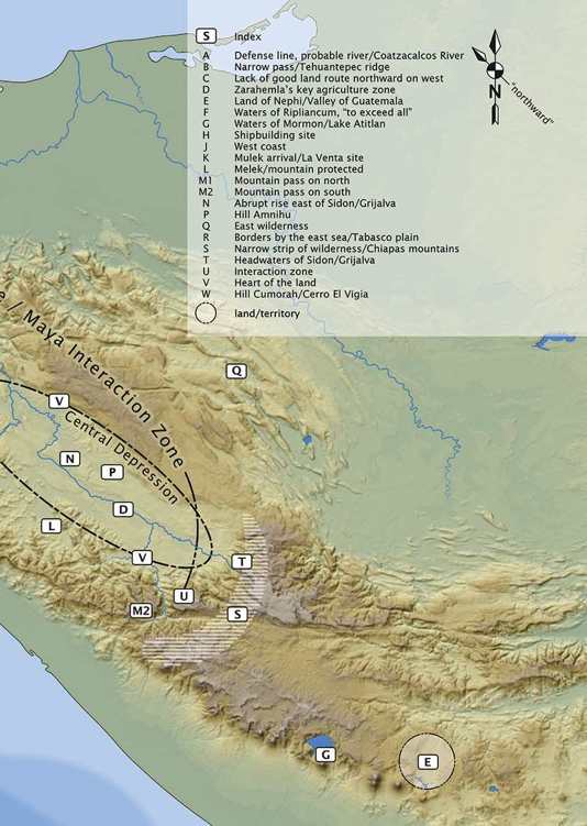
Visit http://bit.ly/18pKujG for a high-resolution image.
Map 5. Plausible Nephite areas in the Valley of Guatemala
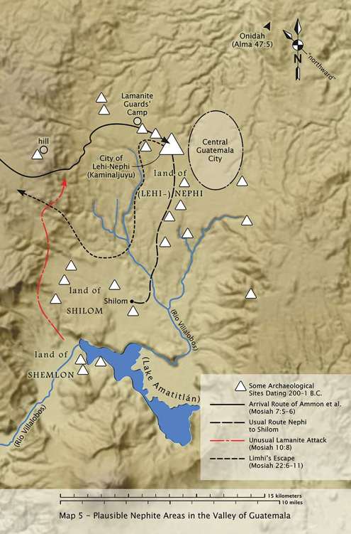
Visit http://bit.ly/14Hz2Ao for a high-resolution image.
Map 6. Plausible Chiapas arena for the Amlicite battles
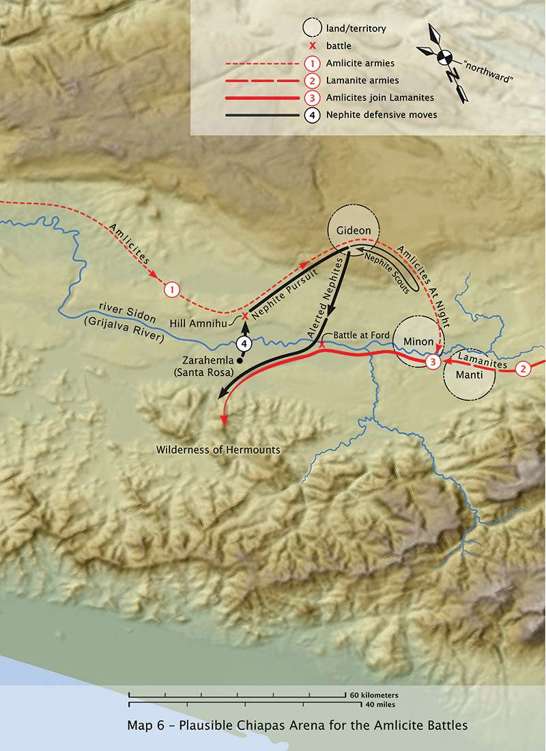
Visit http://bit.ly/182Kjfe for a high-resolution image.
Map 7. Dual pattern of residence at Santa Rosa, ca. 150 BC
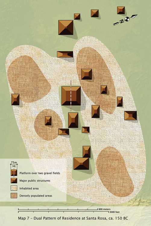
Visit http://bit.ly/1eHfO3D for a high-resolution image.
Map 8. Plausible areas of Alma2s preaching journey
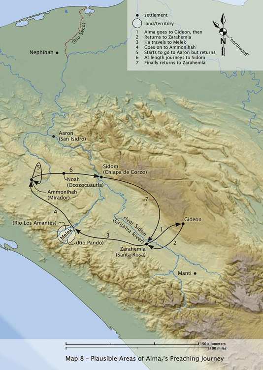
Visit http://bit.ly/1eHfNg6 for a high-resolution image.
Map 9. Plausible sites of the Nephite wars
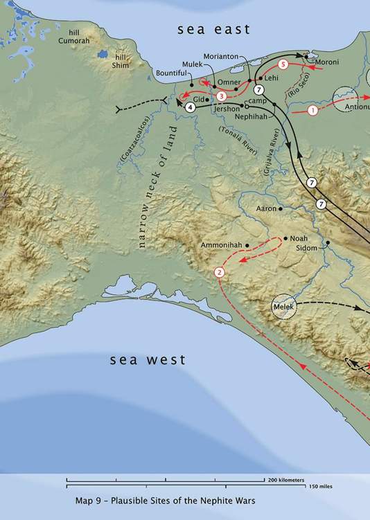
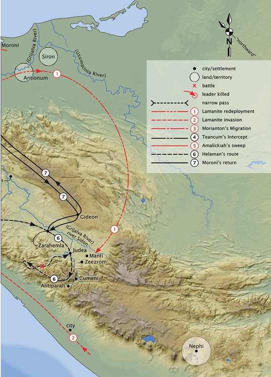
Visit http://bit.ly/15tEh9m for a high-resolution image.
Map 10. Plausible setting for the final Nephite wars
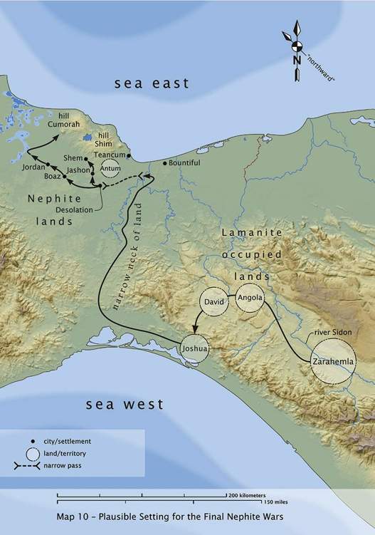
Visit http://bit.ly/16zFm9V for a high-resolution image.
Map 11. Plausible Jaredite lands
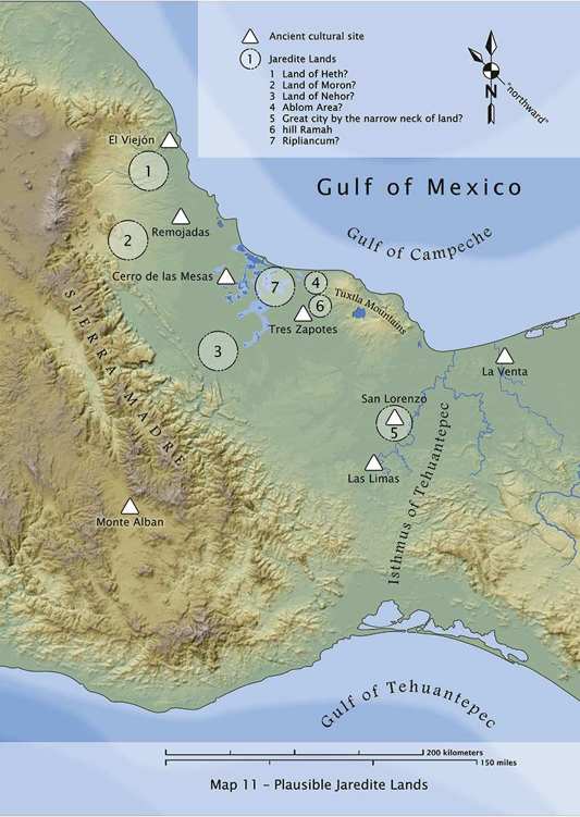
Visit http://bit.ly/14Hzte3 for a high-resolution image.
List of Tables
Table 3.1. Phases of Jaredite Culture History 28
Table 3.2. Phases of Nephite Culture History 32
Table 4.1. Pre-Classic Chronology 73
Table 9.1. Transoceanic Plant Transfers 153
Table 9.2. Selected Disease Agents That Demonstrate Transoceanic Voyages 159
Table 10.1. Some Lexical Similarities 182
Table 20.1. Shared Traits Documented or Implied in the Book of Mormon 457
List of Figures
Figure 4.1. Barra phase pottery 71
Figure 6.1. The shooting of Vucub Caquix by Hunahpu, an incident from the Popol Vuh shown in the art of Izapa 115

