Springer International Publishing Switzerland 2015
Megh Raj Dhital Geology of the Nepal Himalaya Regional Geology Reviews 10.1007/978-3-319-02496-7_1
1. Introduction
Knowledge , after all , is of human creation ; and, as a rule , the knowledge of the structure of a mountain chain comes as the reward of glorious struggle , both physical and mental .
E.B. Bailey (, p. 1)
The enduring geological beauty and arresting grandeur of the Himalaya ( hima = snow, laya = abode in Sanskrit) have attracted investigators from far and wide, especially for the last two centuries. Despite the fact that their knowledge was derived from a limited source or observations were confined to a few isolated regions, some of the pioneers were successful in making astonishingly accurate geological predictions by dint of their ingenious insight into the natural phenomena operating in this immense and insurmountable mountain range. As the rigor of investigation as well as regional coverage steadily increased, newer theories and hypotheses also became prolific.
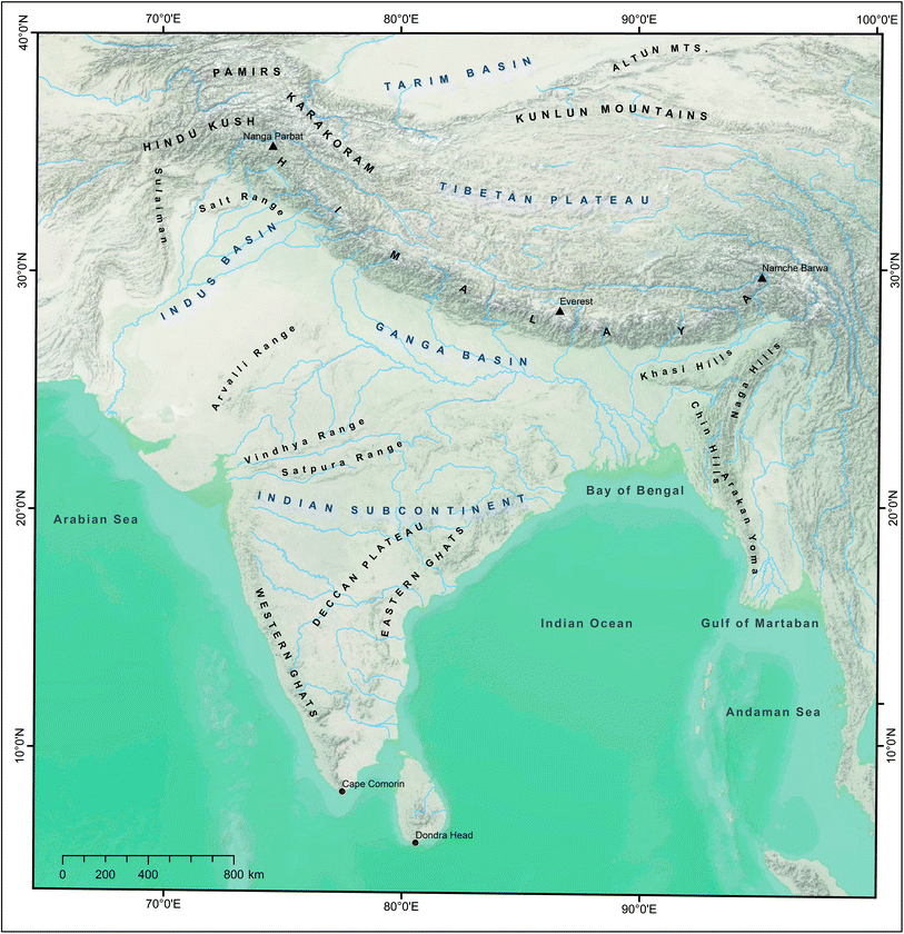
The resplendently located Himalayan Range (Fig. ). The Himalayan belt is also well known for its diverse textures and structures as well as for inverted metamorphismanother outstanding phenomenon.
Fig. 1.1
Tibetan Plateau, Indian Subcontinent, Himalaya, and neighboring mountain ranges. Source Compiled from SRTM DEM, USGS, NOAA, USDA, and GIS User Community
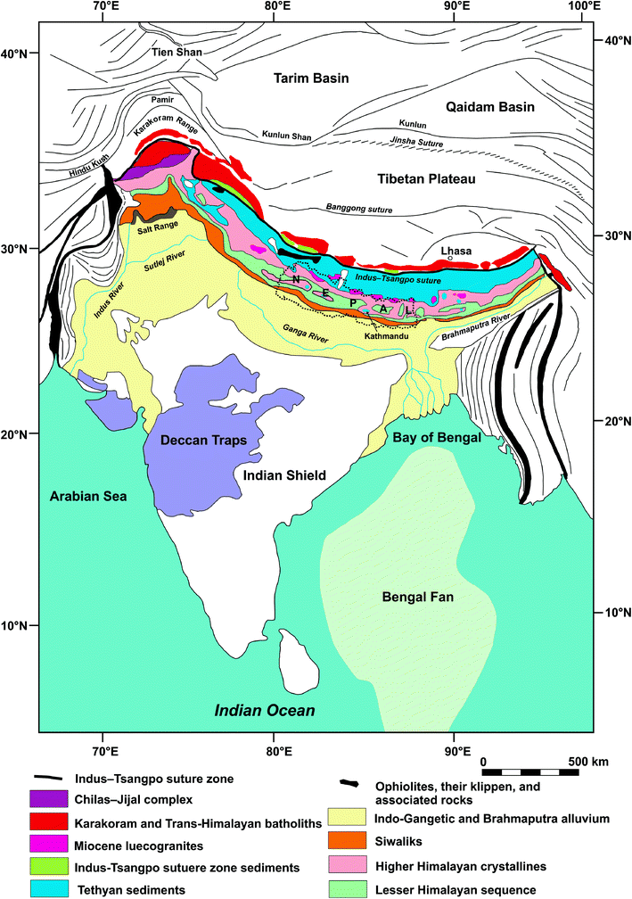
Fig. 1.2
Simplified geological map of Himalaya and position of Nepal. Source Modified from Stcklin ()
This worlds loftiest orogenic system exhibits evidence of the complete Wilson cycle from the Mesozoic to the Eocene, followed by still ongoing post-collisional deformation (Windley ) deny the diachroneity of collision and state that the IndiaAsia collision took place synchronously in the western and eastern Tethyan Himalaya at 50.6 0.2 Ma.
Fig. 1.3
Collision between India and Asia as visualized by Argand. Source Modified from Argand (, p. 349)
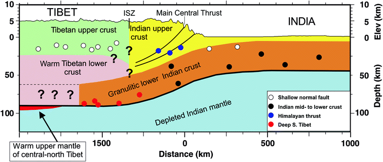
Fig. 1.4
Schematic cross-section through the Himalaya to illustrate the relations between structure and earthquake distribution. Black dots are earthquakes within the underthrusting Indian shield, and occur down to the Moho. White dots are shallow normal faulting events, mostly in Tibet but also at the top of the flexing Indian shield beneath the Ganga foreland basin. Blue dots are shallow-dipping thrusts at ~15 km depth on the main underthrusting interface(s) beneath the Himalaya. The rigid, strong, granulitic lower crust of India is underthrust beneath the Himalaya, and to an unknown distance farther north, indicated by question marks. This Indian lower crust helps support the elevation of Tibet, because the only way Tibet can collapse is by the flow of the warm, weak lower Tibetan crust over this rigid base, which is a slow dissipative process. The precise configurations of geological boundaries indicated by question marks beneath the IndusTsangpo suture zone (ISZ) are unknown. Source Jackson et al. (). Geological Society of London. Used by permission
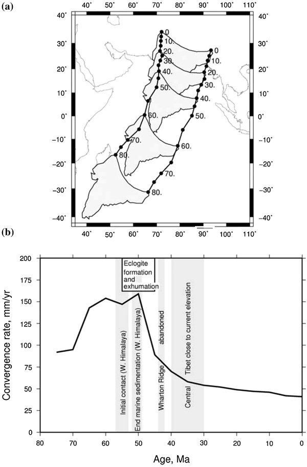
The convergence velocity between Eurasia and India changed significantly (from 15 to 4 cm/a) about 5035 Ma (Fig. ).
Fig. 1.5
a Flight of India and collision with the rest of Asia. The black lines show the positions since 80 Ma, in a Eurasia-fixed reference frame. Positions are labeled with the time in million years. The reconstructed locations of the present-day outline of the Indian subcontinent are shown at 20 Ma increments. b The black line shows the rate of convergence between India and Asia since 75 Ma (at a point currently located at 28 N, 80 E). The gray bands show the timings of notable events in the history of the IndiaAsia collision. Also shown are the timings of eclogite formation and exhumation, which probably record the end of subduction in the region. The collision is thought to have begun at the western part of the plate boundary (i.e., the dates shown indicate the time of initial contact of the continental margins and the end of marine sedimentation) and propagated eastwards over the subsequent 510 Ma. Source Copley et al. (). John Wiley and Sons Ltd. Used by permission
The Himalayan realm contains a mosaic of Paleoproterozoic to Cenozoic rocks with heterogeneous composition and tectonic style. These rocks are telescoped by long-distance tectonic transport (Brookfield ).
1.1 Early Investigations
The eighteenth- and early nineteenth-century geological investigations in the Himalaya were sporadic and sketchy. New theories and hypotheses emerged right from the Neptunistic views on the origin of different rock and mineral groups to the Plutonistic views on the origin of granites. Some of the early researchers (called the naturalists) focused their attention on mineral wealth and physical geology; others were interested in fauna, flora, topography, or climate; whereas a few of them described various Himalayan rock types in terms of Abraham G. Werners stratigraphic scheme of Primary, Secondary, and Tertiary strata.
There were very early views on the central crystalline axis (Stoliczka ) as a barrier comprising metamorphic or igneous core versus sedimentary cover underlain by the Indian shield rocks; there were unrelenting debates on the geosynclinal origin of the Himalaya versus its development from a reactivated platform, and contracting earth versus expanding earth. All kinds of such hypotheses ultimately faded away when the plate tectonic paradigm prevailed in the 1960s.
Calder () defined the Main Central Thrust as a major intracrustal dislocation. As in the Alps, they also contemplated the Main Boundary Thrust as a phenomenon of relief thrusting.
In the Russian literature, Rezvoi (), who proposed various nappes or thrust sheets (such as the Darjeeling, Kathmandu, and Nawakot nappes) in the Himalaya. But Rezvoi denied such interpretations and believed in some short-distant thrusts developed in the reactivated Indian platform.
The iconic Nepal Himalaya had remained virtually virgin to geoscientists until 1950. But soon after, a truly international endeavor of geologists, taking part in mountaineering expeditions, and especially the 9-year-long untiring investigations of Toni Hagen, made mysterious Nepal one of the most enticing and extensively investigated segments of the Himalayan arc.
1.2 Classification Schemes
There have been various attempts to classify the Himalaya. For example, Strachey () identified the following divisions in the Himalaya and surrounding region (from south to north).

