Once there was a legend that told of a river that went to hear a fountain sing. The song was so beautiful that the river decided to sing it to the ocean. All the way to the shores of the ocean the river sang. Soon, the mountains heard of the song that the river was singing and came from all over the land to listen. And because the song was so beautiful the mountains settled down and stayed to listen forever.
Algonquin Indian Legend
Canoeing & Kayaking Georgia
Copyright 2004 by Suzanne Welander, Bob Sehlinger, and Don Otey
All rights reserved
Portions of this book originally appeared in A Paddlers Guide to Northern Georgia and A Paddlers Guide to Southern Georgia
Published by Menasha Ridge Press
Distributed by Publishers Group West
Printed in the United States of America
First edition, third printing, 2010
Library of Congress cataloging-in-publication data
Welander, Suzanne
A Canoeing and Kayaking Guide to Georgia/by Suzanne
Welander, Bob Sehlinger, and Don Otey
p.cm.
ISBN 978-0-89732-558-5
1. Canoes and canoeingGeorgiaGuidebooks. 2. KayakingGeorgiaGuidebooks. 3. GeorgiaGuidebooks. I. Sehlinger, Bob, 1945II. Otey, Don. III. Title.
GV776.G4W45 2004
797.12209758dc22
2003071016
Cover photo 2003 by Suzanne Welander
Interior photos as noted
Cover design by Alian Design
Text design by Ann Marie Healy
Menasha Ridge Press
P.O. Box 43673
Birmingham, Alabama 35243
www.menasharidge.com
DISCLAIMER
While every effort has been made to insure the accuracy of this guidebook, river and road conditions can change greatly from year to year. This book is intended as a general guide. Whitewater paddling is an assumed-risk sport. The decision to run a river can only be made after an on-the-spot inspection, and a run should not be attempted without proper equipment and safety precautions. The author and publisher of Canoeing Kayaking Georgia are not responsible for any personal or property damage that may result from your activities. By using any part of this guide, you recognize and assume all risks and acknowledge that you are responsible for your own actions.

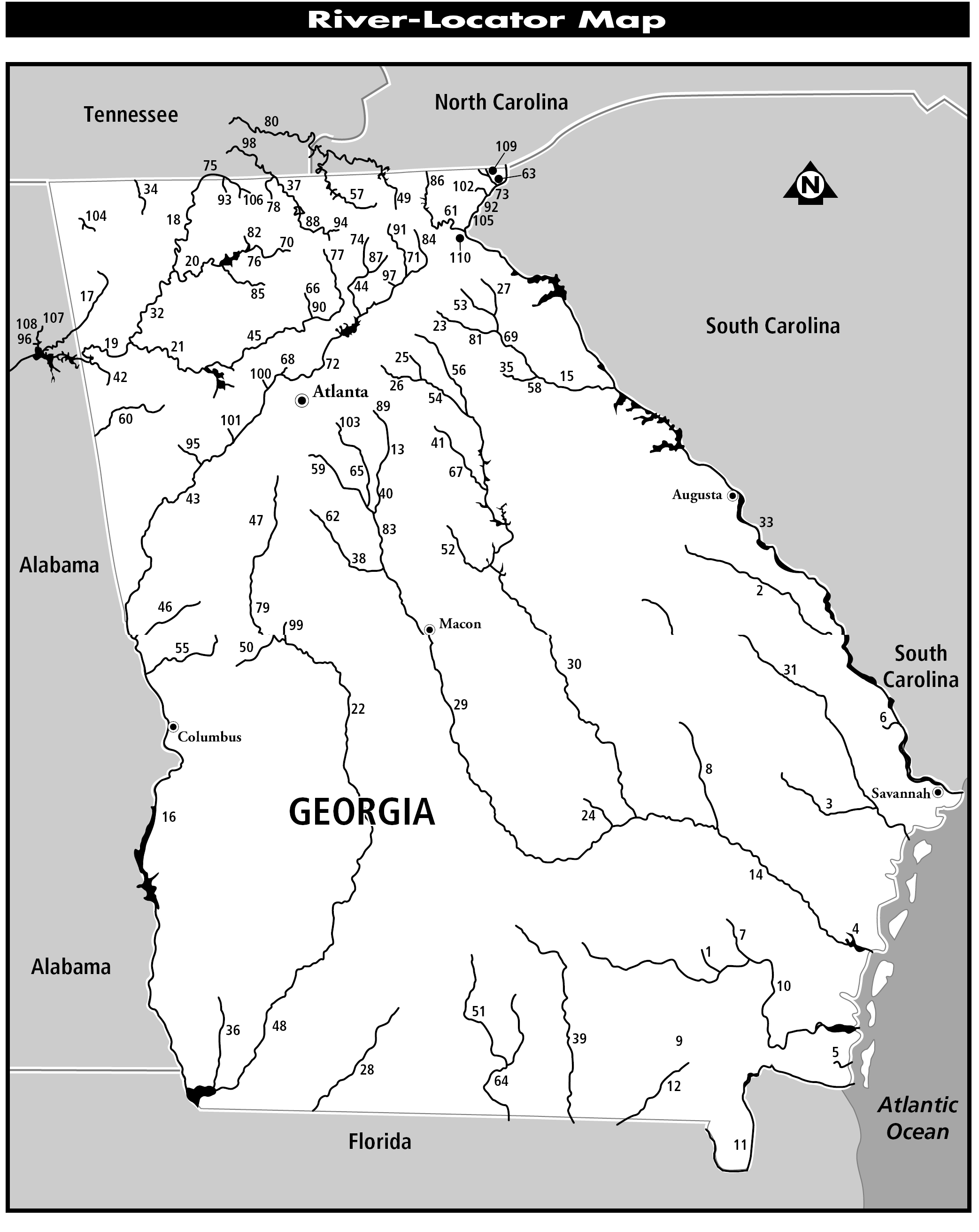
River-Locator Map Key
Tidal and Smoothwater
Class I
Mild (or Portagable) Whitewater
64 Withlacochee River
Moderate Whitewater
Class III+ Creeks and Class IVIV+ Rivers
Class V Rivers and Creeks
Using the River-Locator Map
Use the preceding locator map to find rivers within your paddling expertise located near your geographic region. Following the map is a key that groups Georgias rivers in six difficulty categories:
Tidal and Smoothwater rivers that present no significant obstacles.
Class I rivers, some with fast current and/or a rare Class I shoal. May contain dams that require portaging.
Mild (or Portagable) Whitewater of Class I and II with a general demeanor of smoothwater or Class I rapids but with more difficult Class IIIV rapids interspersed at wide intervals. The more difficult drops can either be portaged by novice paddlers or, depending on road access, can present park-and-play opportunities for those wishing to avoid the intervening flatwater.
Moderate Whitewater that presents a more consistent whitewater experience with a difficulty level of Class II or Class III. May contain a more significant rapid with a higher difficulty rating that can usually be portaged.
Class III+ Creeks and Class IVIV+ Rivers, includng some with continuous whitewater and some with a drop-and-pool character. Portaging the larger drops is generally possible, though it can be difficult. On steep creeks portaging the more difficult rapids is challenging to impossible.
Class V Rivers and Creeks, many in extremely remote settings where rescue would be difficult.
Rivers are listed alphabetically within each category. The numbers on the map correspond to the category lists. Note that some rivers are listed in more than one category. In such cases, river divisions are delineated in detail within the text. Some waterways, particularly longer river sections, display a greater variety of difficulty than can be represented here; read the full description of the river section to tailor your trip to your skill level. The page number for each description is shown alongside each rivers name. Remember that rivers are grouped based on their characteristic under ideal conditions, and high water levels may greatly increase risk. See to gain a deeper understanding the difficulty classes and the skills required to paddle each.
Acknowledgments
A varied group of paddlers contributed expert assistance to this guidebook. This project has been a group effort; the Editrix wishes to acknowledge their contributions, which greatly enhanced the completeness and accuracy of this new edition.
Two individuals in particular had a significant influence on the content:
Dr. William Hawk Reeves took the initiative to ensure that a sample of Georgias steep creek runs would be included, providing the source material used to describe Potato, Cooper, Sope, Mossy and Warwoman Creeks.
Roger Nott, in addition to writing the description for the Jacks River, freely lent editorial advice, his encyclopedic knowledge of north Georgias whitewater streams, and twenty-five years worth of archived newsletters (including a virtual treasure-trove of trip reports, experiential articles and an early guidebook) from the Georgia Canoeing Association.
The following paddlers wrote descriptions new to this edition:
Mark DAgostino
Julia Franks
Dan Grissette
Allen Hedden
Mark Hicks
Slick
Little River Canyon
Tallulah Gorge
Cathead Creek
Upper Ocoee River
Upper Alcovy and Overflow Creek
Crooked River, Upper Ocmulgee
The following paddlers substantially edited content from the previous edition:
Julia Franks
Allen Hedden
Lindsay Meeks and Brookie Gallagher
Chattooga Section IV
Middle Ocoee
Okefenokee Swamp
These local experts provided essential input for new content:
Clay Wright
Dave Chafin
Steve Braden
Michael Moody and Charlie Ford
Bear Creek
Ebenezer Creek
Georgia Coast
Altamaha River
Gratitude also belongs to the following fine folks: Michael Moody for editorial assistance and descriptions of the Broad River watersheds; Dick Hurd, who volunteered updates and a new map for the Cartecay River; Dan Roper who scouted access and shared his paddling experiences on the upper Ogeechee River; Dr. Richard Greene for providing a virtual trip down the Flint River using the sights, experiences and detailed notes compiled on his solo journey to the Gulf; Dave Gale for providing updates and advice for the Upper Chattahoochee; Jed Dugger and his maps of the Little River Canyon; Dick Sturtevant for freely answering questions and volunteering information on the Alapaha and Withlacoochee Rivers; Mark Hicks for sharing his knowledge and enthusiasm for high-water Piedmont play-spots within driving distance for an after-work (or lunch hour) run; Will Reeves and Brad Roberts for editorial guidance on steep creek inclusions (as well as a copy of Fault Line from Wills vault); and Elizabeth Carter for advice on Georgias smoothwater streams.

