Title Page
BENEATH THE 2012 OLYMPICS
A History Of The Queen Elizabeth II Olympic Park
By Stan Medland and Simon Rodway
Publisher Information
First published in 2013 by
Apex Publishing Ltd
PO Box 7086, Clacton on Sea
Essex, CO15 5WN, England
www.apexpublishing.co.uk
Digital edition converted and distributed in 2013 by
Andrews UK Limited
www.andrewsuk.com
Copyright 2013 Stan Medland and Simon Rodway
All rights reserved. This book is sold subject to the condition, that no part of this book is to be reproduced, in any shape or form. Or by way of trade, stored in a retrieval system or transmitted in any form or by any means, electronic, mechanical, photocopying, recording, be lent, re-sold, hired out or otherwise circulated in any form of binding or cover other than that in which it is published and without a similar condition, including this condition being imposed on the subsequent purchaser, without prior permission of the copyright holder.
Beneath The 2012 Olympics
The Queen Elizabeth Olympic Park will include five new neighbourhoods, new health centres, several new schools, some 8,000 new homes - approximately one third of which will be affordable for local people - as well as dozens of new open play spaces.
Stan Medland and Simon Rodway, London Blue Badge tourist guides, specialise in East London, and the 2012 Games in particular. Beneath all that sporting prowess which dazzled the planet, there is a rich local London history.
Come with us and explore some of the fascinating social and industrial history that lies beneath East Londons Olympic park.
On the evening of Friday 27th July 2012, a Lancashireman, Danny Boyle, delivered what Time Out described as a national antidepressant, the Olympic Opening Ceremony.
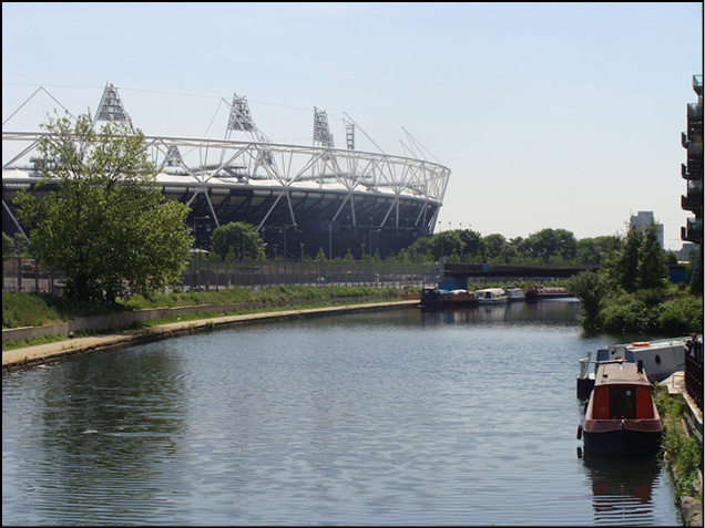
For six weeks the rain held off and the worlds TV networks panned across 220 hectares of East London, to the bowl of brilliance - the Olympic Stadium.
Those Brits that ignored the London Mayors warning to avoid Central London, had the time of their lives, chatting on the tube to the likes of Columbian sports coaches and the families of Canadian athletes.
Blue Badge tourist guides Stan Medland and Simon Rodway, worked throughout the Games, bringing professional tours to the edge of the Park. With our Blue Badge colleagues either on foot, train or coach we brought over 250,000 tourists to East London, to hear the roar of the crowd and get a taste of 2012 Olympic magic.
Then, after all the excitement and sporting glory, after the Olympic and Paralympic flames died, 220 hectares of East London settled down to fulfill the second part of its promise. To become a new postcode for London, E20.
This is old London ground, the Lower Lea Valley, the ancient Stratford Marshes - once a ravaged industrial landscape much like the one depicted in Danny Boyles Opening Ceremony.
But earlier on, it was rich in fish, bird and animal life.
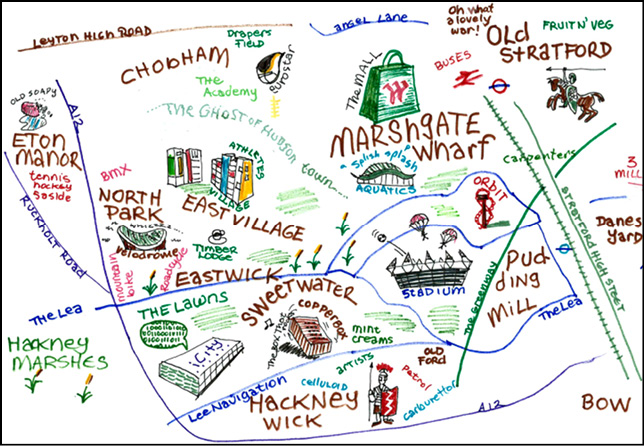
The new neighbourhoods -
Marshgate Wharf...
Pudding Mill...
Sweetwater...
East Wick...
Chobham Farm/East Village...
Other areas include
Stratford Village...
Bow...
River Lea...
North Park...
South Park...
Eton Manor...
Beneath Stratford Village
Stratford is an ancient hamlet on the east bank of the river Lea, and came to world renown as the Gateway to the London 2012 Olympic Games. Whats in a name? Stratford - well, the name says it all - straight road fording a river. Up in Warwickshire, that other Stratford, Shakespeares birthplace, means exactly the same thing - a straight road across a river (in Warwickshire the river is the Avon, in London it is the River Lea, a tributary of the River Thames..
Londons version appears on later maps as Stratford-atte-Bow or Stratford-le-Bow.
At this point in our story of the Olympic Park, the Romans appear. These are the people who introduced Britain to the joys of glass, central heating and sausages. Happily, one particular Roman culinary delight that didnt make the distance was roasted dormice, rolled in honey and dusted with poppy seeds.
The Roman High Road to Colchester
The Roman Empire arrived in earnest in 43AD, adding Britannia as the most westerly province of their vast empire. Once the pesky Celts were subdued, the Emperor Claudius turned up riding an elephant to take the salute from the victorious legions.
The Romans rewarded their veterans with a retirement city at Camulodunum in Essex. (modern Colchester, Britains oldest recorded town).
The road from Londinium to Camulodunum ran somewhere through the middle of the Olympic Park; its difficult to trace the exact route as the Lea is a frequent flooder.
Generally the Roman road system knitted together the whole Mediterranean world. For the first time you could travel from Britain to Iraq in reasonable comfort and at reasonable speed - Imperial messengers were expected to cover 50 miles a day on horseback.
The Empires roads are why it lasted as long as it did. Un-metalled roads soon disintegrate under the weight of feet, wheels and hooves. In winter they become muddy quagmires, in summer choking dust bowls. To a Roman general this would rule out any attempt at reliable campaign planning.
For 600 years the Roman army used the Empires roads to get quickly to trouble spots. Way out in the far provinces you might be planning a revolt, but hold on - those straight roads carried a lot of potential menace of future retribution.
The sure knowledge that the legions would arrive sooner or later, greatly helped to keep Pax Romana (the Roman Peace) up and running, and kept local hotheads muttering harmlessly into their tankards of ale.
These provided the easiest, and quickest routes - straight stretches and gentle gradients to minimise human and horse fatigue. Roman roads let an army cover 25 miles in a day on foot and were broad enough to allow a legion to deploy quickly into battle order.
Roman roads are all over London - Old Kent Road, Kilburn High Road, Kingsland Road, Oxford Street, Goldhawk Road, Chiswick High Street, Kensington High Street and the aptly named Roman Road in Bow, leading to Old Ford.
In time the Anglo Saxons pushed aside the Romano-British, but soon the traditional Anglo Saxon measure of property the hide, disappeared as craftsmen and merchants filled the city acres replacing the old family-based social systems. The professional guilds based on skills appeared, and were soon educating and policing themselves, setting their own prices and generally looking after their collective interests.
The guilds defended their members rights, helping keep King and Church at arms length. Many of these venerable organisations survive to this day in the City of London as Ancient Livery Companies.
A London Guild At Stratford
The guilds left their mark even out on the Olympic Park. A local example is the Carpenters Estate lying to the south of the Park, with the aptly titled Carpenters Road passing through the centre, named after a farm acquired by the Guild. Founded in the 13 th Century, the Honorable Carpenters Company supported the interests of the all-important wood worker. The Company has been based near London Wall in the heart of the City of London since 1429. It received a Royal Charter in 1477.
In 1767 the Carpenters purchased their farm at Stratford, eventually in the 1830s selling off sections to the all-devouring Great Eastern Railway. The Carpenters played an important role in Stratford, opening a evening institute in 1886 offering classes in carpentry, plumbing, geometry, mechanical engineering and even cookery! By 1891 there was also a day school for boys and one old boy was the immortal Stanley Holloway OBE, actor and comedian, and Mr Doolittle the eloquent rubbishman in the movie My Fair Lady.
Next page

