Karen C. Pinto - Medieval Islamic Maps: An Exploration
Here you can read online Karen C. Pinto - Medieval Islamic Maps: An Exploration full text of the book (entire story) in english for free. Download pdf and epub, get meaning, cover and reviews about this ebook. year: 2016, publisher: University of Chicago Press, genre: Romance novel. Description of the work, (preface) as well as reviews are available. Best literature library LitArk.com created for fans of good reading and offers a wide selection of genres:
Romance novel
Science fiction
Adventure
Detective
Science
History
Home and family
Prose
Art
Politics
Computer
Non-fiction
Religion
Business
Children
Humor
Choose a favorite category and find really read worthwhile books. Enjoy immersion in the world of imagination, feel the emotions of the characters or learn something new for yourself, make an fascinating discovery.

- Book:Medieval Islamic Maps: An Exploration
- Author:
- Publisher:University of Chicago Press
- Genre:
- Year:2016
- Rating:4 / 5
- Favourites:Add to favourites
- Your mark:
Medieval Islamic Maps: An Exploration: summary, description and annotation
We offer to read an annotation, description, summary or preface (depends on what the author of the book "Medieval Islamic Maps: An Exploration" wrote himself). If you haven't found the necessary information about the book — write in the comments, we will try to find it.
Karen C. Pinto: author's other books
Who wrote Medieval Islamic Maps: An Exploration? Find out the surname, the name of the author of the book and a list of all author's works by series.


Medieval Islamic Maps: An Exploration — read online for free the complete book (whole text) full work
Below is the text of the book, divided by pages. System saving the place of the last page read, allows you to conveniently read the book "Medieval Islamic Maps: An Exploration" online for free, without having to search again every time where you left off. Put a bookmark, and you can go to the page where you finished reading at any time.
Font size:
Interval:
Bookmark:

Karen C. Pinto
The University of Chicago Press /
Chicago and London
Karen C. Pinto is assistant professor of Islamic and Middle Eastern history at Boise State University.
The University of Chicago Press, Chicago 60637
The University of Chicago Press, Ltd., London
2016 by The University of Chicago
All rights reserved. Published 2016.
Printed in China
25 24 23 22 21 20 19 18 17 16 1 2 3 4 5
Parts of chapters originally appeared in Views from the Edge, edited by Neguin Yavari, Lawrence G. Potter, and Jean Marc Ran Oppenheim. Copyright 2004 The Middle East Institute. Reprinted with permission from Columbia University Press.
Parts of chapters ).
ISBN-13: 978-0-226-12696-8 (cloth)
ISBN-13: 978-0-226-12701-9 (e-book)
DOI: 10.7208/chicago/9780226127019.001.0001
Library of Congress Cataloging-in-Publication Data
Pinto, Karen C., author.
Medieval Islamic maps : an exploration / Karen C. Pinto.
pages cm
Includes bibliographical references and index.
ISBN 978-0-226-12696-8 (cloth : alk. paper) ISBN 978-0-226-12701-9 (e-book) 1. CartographyIslamic countriesHistory. 2. Geography, Arab. I. Title.
GA221.P56 2016
912.092'21767dc23
2015017867
 This paper meets the requirements of ANSI / NISO Z39.48-1992 (Permanence of Paper).
In loving memory of my parents,
Adele Berthe Pinto
(19282008)
and
Lt. Col. Felice George Pinto
(19181984)
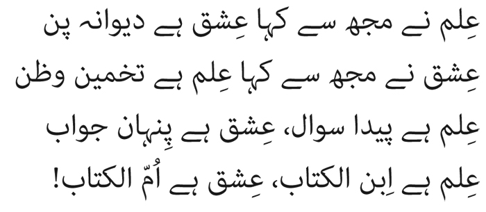
Knowledge said to me, Love is madness;
Love said to me, Knowledge is estimation and presumption.
Knowledge is born a question, Love is the hidden answer;
Knowledge is Son of the Book, Love is Mother of the Book!
ALLAMA IQBAL , Ilm wa Ishq (Knowledge and Love)
It is seeing which establishes our place in the surrounding world; we explain that world with words, but words can never undo the fact that we are surrounded by it. The relation between what we see and what we know is never settled.
JOHN BERGER , Ways of Seeing
A book involving the admixture of Arabic, Persian, and Ottoman transliteration systems is, as I have discovered, no easy matter. The standard IJMES system, which I employ throughout this book, does not fit Ottoman transliteration well. Thus, Mehmet becomes Memed but Tr-i Hind-i Gharb (History of the West Indies) cannot be changed to the Arabic form of Trkh. Similarly, Lomn looks odd when transliterated according to the Arabic system as Luqmn. The problem is compounded by modern Turkish, which uses, for example, c for j. Thus, Cerriyyetl-niyye (Imperial Surgery) should be transliterated as Jerriyyet according to the IJMES system, but no one would be able to locate the book under that spelling. For this reason, the transliteration of Ottoman Turkish under the IJMES scheme cannot be foolproof. The case of Persian is easier. I apply the IJMES transliteration convention. Instead of the Persian spelling Iskander, for instance, I use Iskandar according to the Arabic convention. In order to preserve the narrative flow I have removed the prefix al- from the start of Arabic last names. Thus abar instead of al-abar, Mamn instead of al-Mamn, and so on. Exceptions to this are quotes and full names.
Place-names present especially complex choices: Does one list Mecca according to common practice or according to the correct transliteration of Makka? Medina or Madina? More vexing is the correct use of names for which a local equivalent has become popular. Seville versus Sevilla is a case in point. Troublesome is the spelling for the East African tribe that forms the core of chapters : Buja according to Arabic orthography or Beja according to common practice? I decided in favor of common practice. So I use Mecca, Medina, Sevilla, and Beja. I transliterate only those place-names that I judge as being not well known or without an Arabic alternativefor example, Ifrqiya, Zaghwa, and Mafza al-Buja.
In cases where usage of a word is common, I do not list it in its transliterated form (e.g., sultan not suln). Exceptions to this are references to the Qurn and adth. I also elected to not transliterate dynastic names. Outside of what falls into the domain of common practice, I chose to transliterate all Arabic, Persian, and Turkish words, names, and book titles. I may have missed a few and for this the error lies with me alone.
In short, I use a hybrid IJMES system in consultation with the method adopted by the associate editor of book 1 of the second volume of The History of Cartography, Ahmet Karamustafa, who also had to wrestle with the transliteration scheme of three different languages and the place-name dilemma and developed brilliant solutions.
All translations are my own unless otherwise noted.
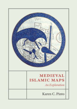
They present instead a deliberately schematic layout of the world and the regions under Islamic control.
These images employ a language of stylized forms that make them hard to recognize as maps. Scholars of Islamic science and geography often ignore and belittle these maps
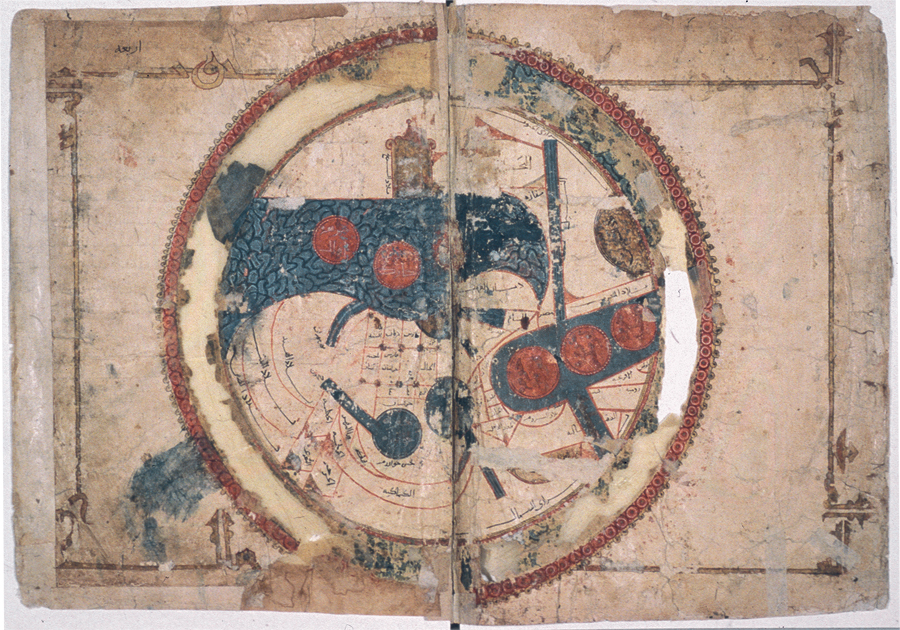
Fig. 1.1. Classic KMMS world map, rat al-Ar (Picture of the World), from an abbreviated copy of al-Iakhrs Kitb al-maslik wa-al-mamlik (Book of Routes and Realms). 589 / 1193. Mediterranean. Gouache and ink on paper. Diameter 37.5 cm. Courtesy: Leiden University Libraries. Cod. Or. 3101, fols. 45.
On the surface it seems that these often elaborately illuminated nonmimetic cartographic works, employing pigments made from precious metals and stones, must have been produced for the elite literati of medieval Islamic society such as the commissioners / patrons, collectors, copyists, and high-status readers of the geographic texts within which these maps are found. This conclusion ignores the easy-to-replicate nature of these schematic images, which would have enabled students visiting the libraries of sultans, amirs, and other members of the ruling elite to transport basic versions of these carto-ideographs back to the people of their villages and far-flung areas of the Islamic world.
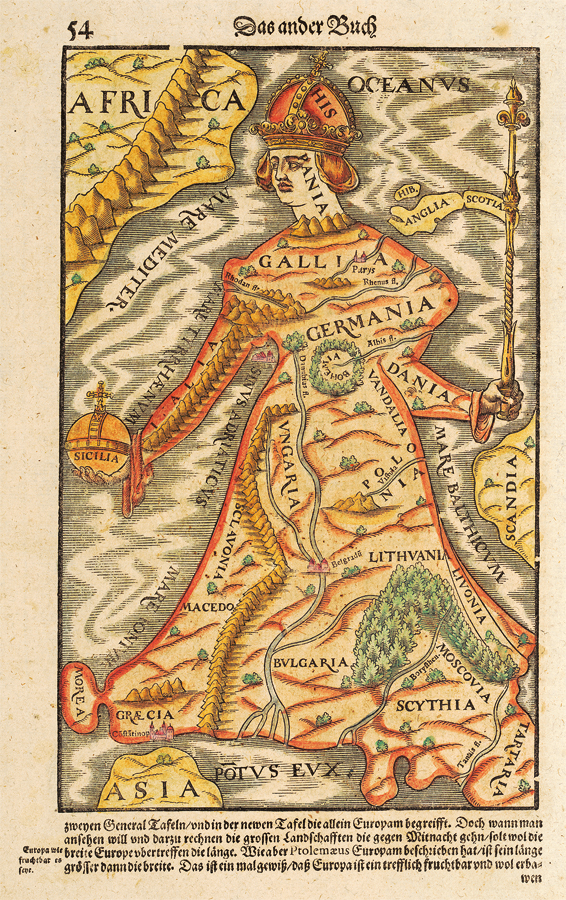
). To simply dismiss this map as an inaccurate representation of Europe and therefore an invalid source is to miss the point. It is reflective of a much deeper sociocultural, historical, and political context that needs to be read and interpreted. Are the metaphorical coastlines reflective of an emerging consciousness of European supremacy? Can they not be read as a sort of pre-colonial colonialism with Spain and Portugal leading the way, assisted by the arm of Italy and the pivotal island of Sicily on one side and by the staff of the North Sea formed by the Danes, the English, and the Scots on the other? The Mnster map demonstrates how cartography can be used to navigate the medieval and early modern imagination.
Font size:
Interval:
Bookmark:
Similar books «Medieval Islamic Maps: An Exploration»
Look at similar books to Medieval Islamic Maps: An Exploration. We have selected literature similar in name and meaning in the hope of providing readers with more options to find new, interesting, not yet read works.
Discussion, reviews of the book Medieval Islamic Maps: An Exploration and just readers' own opinions. Leave your comments, write what you think about the work, its meaning or the main characters. Specify what exactly you liked and what you didn't like, and why you think so.