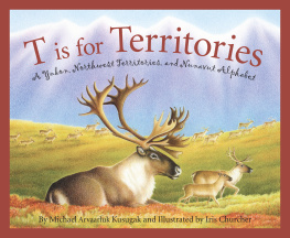
T is for Territories
A Yukon, Northwest Territories, and Nunavut Alphabet
Written by Michael Arvaarluk Kusugak and Illustrated by Iris Churcher
M is for my most wonderful irnngutaq (granddaughter),
Makayla Marie Navvaq Kusugak.
Michael

Dedicated to my parents, John and Dorothy Browne,
and good friends Joan, Jean, Annie, and Robin for
their loving and generous support.
Iris
ART CREDITS
Iris Churcher gratefully acknowledges the following individuals and organizations for participating as models, providing resource materials, and granting permission for image usage.
DModel: Michael Arvaarluk Kusugak
FThe Dakhk Khwan Dancers, Whitehorse, Yukon, Canada
GThe Arctic Winter Games International Committee, Whitehorse, Yukon, Canada, for Arm Pull and Pole Push; Northern Games Society, Inuvik, Northwest Territories, Canada, for One-foot high kick Models for medal winners: Carla and Isaac Jack
KUniversity of Washington Libraries, Special Collections, AWC3847 for the gold rush prospectors climbing up the pass Model for prospector: Rick Conroy
LThe models are:
1. FrenchLeeland James Lagasse
2. English and DogribAlexandra Gordon
3. InuvialuitCharlie Gordon
4. InukitutOwen Anawak
PAlex Waterhouse-Hayward, photographer
SLeiff Josefsen, photographer
VSimon Norris, photographer
XNorthwest Territories Literacy Council, Yellowknife, Northwest Territories, Canada, for Peter Gzowski photo
Text Copyright 2013 Michael Arvaarluk Kusugak
Illustration Copyright 2013 Iris Churcher
All rights reserved. No part of this book may be reproduced in any manner without the express written consent of the publisher, except in the case of brief excerpts in critical reviews and articles. All inquiries should be addressed to:
Sleeping Bear Press TM
315 E. Eisenhower Parkway, Ste. 200
Ann Arbor, MI 48108
www.sleepingbearpress.com
Printed and bound in the United States.
10 9 8 7 6 5 4 3 2 1
Library of Congress Cataloging-in-Publication Data
Kusugak, Michael.
T is for territories : a Yukon, Northwest Territories, and Nunavut alphabet / written by Michael Arvaarluk Kusugak ; illustrated by Iris Churcher.
p. cm.
ISBN 978-1-58536-207-3
1. YukonJuvenile literature. 2. Northwest TerritoriesJuvenile literature. 3. NunavutJuvenile literature. 4. Alphabet books. I. Churcher, Iris, ill. II. Title.
F1060.35.K87 2013
971.93dc23
2012008123
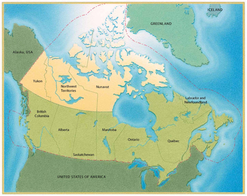
At the north end of the North American Continent, lined up side-by-side, west to east, are four parcels of land: The Alaskan state of the United States of America and three Canadian territories. This is a book about those three Canadian territoriesYukon, Northwest Territories, and Nunavut.
Michael Kusugak
A
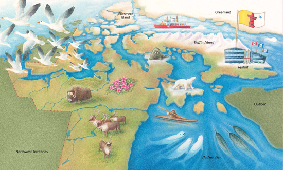
Imagine a territory so vast it pokes into Ontario and Qubec to the south. Then it goes north, all the way to the North Pole. Imagine a territory that needs three time zones: Mountain, Central, and Eastern Time. Imagine a territory that has the second-largest bay in the world, Hudson Bay. What you imagine is NunavutOur Land, in Inuktitut, the language of the Inuit.
The Thuleancestors of present-day Inuitinhabited the territory 4,000 years ago. The first European contact was made by the Norse in the eleventh century. Martin Frobisher arrived in 1576, the first Englishman to set foot in arctic Canada.
On May 25, 1993, the Nunavut Land Claims Agreement Act was signed, with its official passage on July 9. On April 1, 1999, the inhabitants celebrated the ratification of the Agreement. And Nunavut became a territory.
The territory takes up 1,994,000 square kilometres, one-fifth of the land mass of Canada. It is also in the Great Canadian Precambrian Shield, rich in gold, silver, nickel, and other minerals.
There are approximately 32,000 people in Nunavut. Almost 84 percent identify themselves as Inuit. Non-aboriginal people account for almost 15 percent. The rest, only 1 percent, are First Nations and Mtis. About 70 percent speak Inuktitut. The rest speak English, French, and the Inuit in the Kitikmeot (Central) Region speak Inuinnaqtun.
The town of Iqaluit is the capital of the Nunavut Territory. The official floral emblem is the purple saxifrage (Saxifraga oppositifolia). The official animal is the Canadian Inuit Dog (Canis familiaris borealis). The official bird is the rock ptarmigan (Lagopus mutus). There is no official tree. The only trees are way up north on Ellesmere Island, quite dead and mummified.
Nunavut is only accessible by air, sea, or snowmobile. The longest road, Tehek Road, is only 108 kilometres long.
A is for April 1, 1999
In April 1999 politicians came to sign an amendment to the Constitution to add Nunavut to the nation.
B
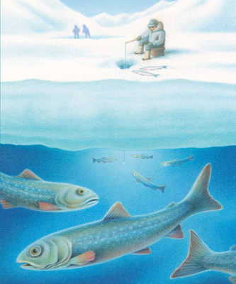
Baffin Island, the largest island in Canada, is also the fifth-largest island in the world. Two and a half Great Britains could fit on it. Its largest community, the town of Iqaluit, has a population of approximately 6,700 people and is the capital of the Nunavut Territory. There are snow-capped mountains. Up at the northern end are glaciers, flowing between the mountains. Pangnirtung, which translates to land-of-the-big-bull-caribou in English, a community on the east coast, is famous for very high winds that whistle through the Pangnirtung Pass. Its buildings are anchored to the ground with cables to keep them from blowing away. People there fish through the sea ice in deep water for turbot, a large flat fish.
The Inuit of the island are famous for their artwork: soapstone carvings, woven tapestries, stone-cut prints. These artists included Kenojuak Ashevak, who was named a Companion of the Order of Canada (a very prestigious honour). Her prints have been used on Canadian postage stamps. She even has a star on Canadas Walk of Fame.
B is for Baffin Island
Baffin Island is so gorgeous, snow-capped mountains and glaciers, flowing. Rocky plateaus and deep gorges get your heart and spirits glowing.
C
One animal that is common to all three Canadian territories is the caribou. Huge caribou herds migrate across the tundra, through the boreal forest and mountain ranges. The Beverly caribou herd spends the summer around Beverly Lake on the tundra, west of Hudson Bay. The Bathurst herd migrates all the way to Bathurst Inlet on the Arctic Ocean. The Porcupine herd migrates through the Northwest Territories and Yukon, along the Porcupine River. Other caribou roam the Arctic Islands. Altogether, there are more than a million caribou that roam the three territories.
The areas where caribou have their calves, the calving grounds, are very important to them. Their enemy is the wolf, so caribou pick a place where they can see them from far away. Shortly after it is born, a caribou calf can run faster than a wolf.
Next page
