Bookmarks
Pagelist
Guide

Active Landscape Photography
How can photography be transformed into an active process of investigation for landscape architecture and environmental design? The second book in Godfreys series, Active Landscape Photography, presents engaged photographic methods that turn photography into a rigorous, thoughtful endeavor for the research, planning and design of landscape places.
Photography is the most ubiquitous and important form of representation in these disciplines. Yet photography is not specifically taught as a core skill within these fields. This book creates a starting point for filling this gap. Concepts and working methods from contemporary photography and critical cultural theories are contextualized into situations encountered in the daily practice of landscape architecture and environmental design. These methods can be integrated into practices in academic and professional settings or picked up and self-taught by an individual reader. : Practices discusses working methods of specific contemporary photographers and extrapolates their practices into common planning and design situations. Contemporary photographers presented include Richard Misrach, Dawoud Bey, Duane Michals, Latoya Ruby Frazier, Mark Klett, Sophie Calle, Joe Deal, Robert Adams, Naima Green, Bernd and Hilla Becher, Stephen Shore, David Hockney, Amy Sherald, William Christenberry, Jeff Wall, and Sohei Nishino.
Beautifully illustrated in full color with over 150 images by Godfrey, her students and contemporary photographers, this book provides both clear guidelines for a set of diverse methods and a deeper discussion about the implications of making and using photography in environmental design for professionals, academics, students and researchers.
Anne C Godfrey is an Assistant Professor in the Department of Landscape Architecture at SUNY College of Environmental Science and Forestry. Her research examines the complex relationship between photography and landscape. As a photographer and writer, she engages in contemporary multidisciplinary inquiries into landscape, perception and design. She is an award-winning educator and researcher.
Active Landscape Photography Methods for Investigation
Anne C Godfrey

Cover image: Anne C Godfrey. Penobscot Bay, Maine.
September 2021
First published 2023
by Routledge
4 Park Square, Milton Park, Abingdon, Oxon OX14 4RN
and by Routledge
605 Third Avenue, New York, NY 10158
Routledge is an imprint of the Taylor & Francis Group, an informa business
2023 Anne C Godfrey
The right of Anne C Godfrey to be identified as author of this work has been asserted in accordance with sections 77 and 78 of the Copyright, Designs and Patents Act 1988.
All rights reserved. No part of this book may be reprinted or reproduced or utilised in any form or by any electronic, mechanical, or other means, now known or hereafter invented, including photocopying and recording, or in any information storage or retrieval system, without permission in writing from the publishers.
Trademark notice: Product or corporate names may be trademarks or registered trademarks, and are used only for identification and explanation without intent to infringe.
British Library Cataloguing-in-Publication Data
A catalogue record for this book is available from the British Library
Library of Congress Cataloging-in-Publication Data
Names: Godfrey, Anne C., author.
Title: Active landscape photography : methods for investigation / Anne C. Godfrey.
Description: Abingdon, Oxon ; New York, NY : Routledge, 2023. | Series: Active landscape photography | Includes bibliographical references and index.
Identifiers: LCCN 2022011469 (print) | LCCN 2022011470 (ebook) | ISBN 9780367248420 (hbk) | ISBN 9780367248444 (pbk) | ISBN 9780429284649 (ebk)
Subjects: LCSH: Landscape architecturePhotographs. | Landscape architecturePictorial works. | Landscape photography.
Classification: LCC SB472 .G634 2023 (print) | LCC SB472 (ebook) | DDC 712.022/2dc23/eng/20220722
LC record available at https://lccn.loc.gov/2022011469
LC ebook record available at https://lccn.loc.gov/2022011470
ISBN: 978-0-367-24842-0 (hbk)
ISBN: 978-0-367-24844-4 (pbk)
ISBN: 978-0-429-28464-9 (ebk)
DOI: 10.4324/9780429284649
Typeset in Futura
by Apex CoVantage, LLC
To Don
Contents
Part I
Methods
Part II
Practices
Introduction
DOI: 10.4324/9780429284649-1
Why Photography Matters, Why Methods Activate Photography
Photography is the most important and accessible tool for design decision making in landscape architecture and the related environmental design disciplines. Photography is made and used to document, investigate and understand landscape sites and contexts. Photographs are viewed throughout the design process to assist in decision making. Photography is a daily helpmate to our work.
Photographs are combined and manipulated with an ever-increasing host of digital software tools. Photographs are used as underlayments for digital design proposals.
Photographs are collaged, morphed and animated to demonstrate design change and finished design results.
Photographs become the basis for 3D renderings and models. They can serve as locating devices for complex mapping processes. Imagery is created through photographic and data collection means to remotely sense and examine landscape characteristics, such as land cover, topography, human use, other animal use and water flows (see ). These photolike images provide understandable visual cues and are referenced for the accuracy of certain elements (such as in the construction of complex 3D maps).
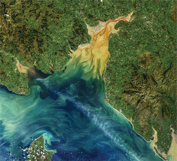
This image of Solway Firth in the United Kingdom was made by the Operational Land Imager (OLI) on the Landsat 8 satellite managed by the National Aeronautics and Space Administration (NASA). The OLI is a remote sensing device that measures the visible, near infrared and shortwave infrared portions of the light spectrum. The image was made to monitor sedimentation patterns on October 2, 2019. NASAs information about this image includes this narrative: The image above is a blend of art and science. Like a photographer who adjusts lighting in a studio, Norman Kuring of NASAs Ocean Biology group works with various software programs and color-filtering techniques to draw out the fine details in the water. The swirls and streamers in Solway Firth are real, but Kuring has separated and enhanced certain shades and tones in the data to make the sediments and dissolved organic matter stand out.
Image: Norman Kuring for NASA.
We use photography to show our work to others. These photographs of finished work appear on websites, social media feeds, web and print media, monographs and reviews. We display photographs of finished work in our offices. We hire photographers to make photographs that specifically demonstrate the successes of our individual projects.
Our work is evaluated through the viewing of photographs. Photographs are submitted to award calls. Most post-occupancy evaluations employ photographs as part of their core methodologies. Photographs are used to demonstrate historic and cultural significance. Sites are monitored with photography. Photographs are assessed to understand change over time.









 This image of Solway Firth in the United Kingdom was made by the Operational Land Imager (OLI) on the Landsat 8 satellite managed by the National Aeronautics and Space Administration (NASA). The OLI is a remote sensing device that measures the visible, near infrared and shortwave infrared portions of the light spectrum. The image was made to monitor sedimentation patterns on October 2, 2019. NASAs information about this image includes this narrative: The image above is a blend of art and science. Like a photographer who adjusts lighting in a studio, Norman Kuring of NASAs Ocean Biology group works with various software programs and color-filtering techniques to draw out the fine details in the water. The swirls and streamers in Solway Firth are real, but Kuring has separated and enhanced certain shades and tones in the data to make the sediments and dissolved organic matter stand out. Image: Norman Kuring for NASA.