Contents

Wallys Beach at St. Mary Reservoir:
A Hike within a Late Pleistocene Landscape
Writing-on-Stone Provincial Park /
snaipi National Historic Site


Introduction
I was born and raised in small towns across Alberta as my family accompanied my father who followed the oil rigs from oil discovery to oil discovery. As a result, I grew up playing in rolling prairies with their broad vistas and deep valleys, and in heavily treed and rugged northern forests.
I discovered the splendor of the Rocky Mountains visiting with my parents traveling from the prairies, later when attending university, and for a time living in Jasper while working for the CNR. I studied mountain geomorphology and carried out research in the Rockies. This led me to write about the spectacular mountain scenery of the Rocky Mountains in my first book Rocks, Ridges, and Rivers: Geological Wonders of Banff, Yoho, and Jasper National Parks (2017).
While at the Geological Survey of Canada, and later at a large Canadian energy company, one of my roles was to understand the geology of Alberta and western Canada. I found gold in cemented gravels of the Rocky Mountain Foothills. Was this gold the origin for the Legend of the Lost Lemon Gold Mine? I drilled for diamonds in volcanic kimberlites of northwestern Alberta where a diamond-exploration company opened their vaults to show me a handful of diamonds, some up to 1.3 carats in weight. I mentored staff for gas and oil exploration and assessed geothermal opportunities in Alberta. I was forever taking groups of people on geological excursions for science and training into the Rocky Mountains, Cypress Hills, Writing-On-Stone Provincial Park, Crowsnest Pass, Drumheller, and elsewhere across the province. It was all quite exciting.
The inspiration for writing this book originated with my long-held passion for both the Alberta prairies and the Rocky Mountains. There is so much to see, understand and appreciate in Albertas landscapes, for which geology and geomorphology are the underpinning control.
Some of the sites described in this tour book are visited by hundreds of thousands of travelers every year because of their spectacular nature. In contrast, several localities are virtually unknown, and are rarely visited, but are just as visually stimulating. Only the locals know of their existence.
These are all landscape gems in Alberta. Put on your hiking boots and fill your car with gas. It is time to explore and learn how Albertas most scenic sites were created.
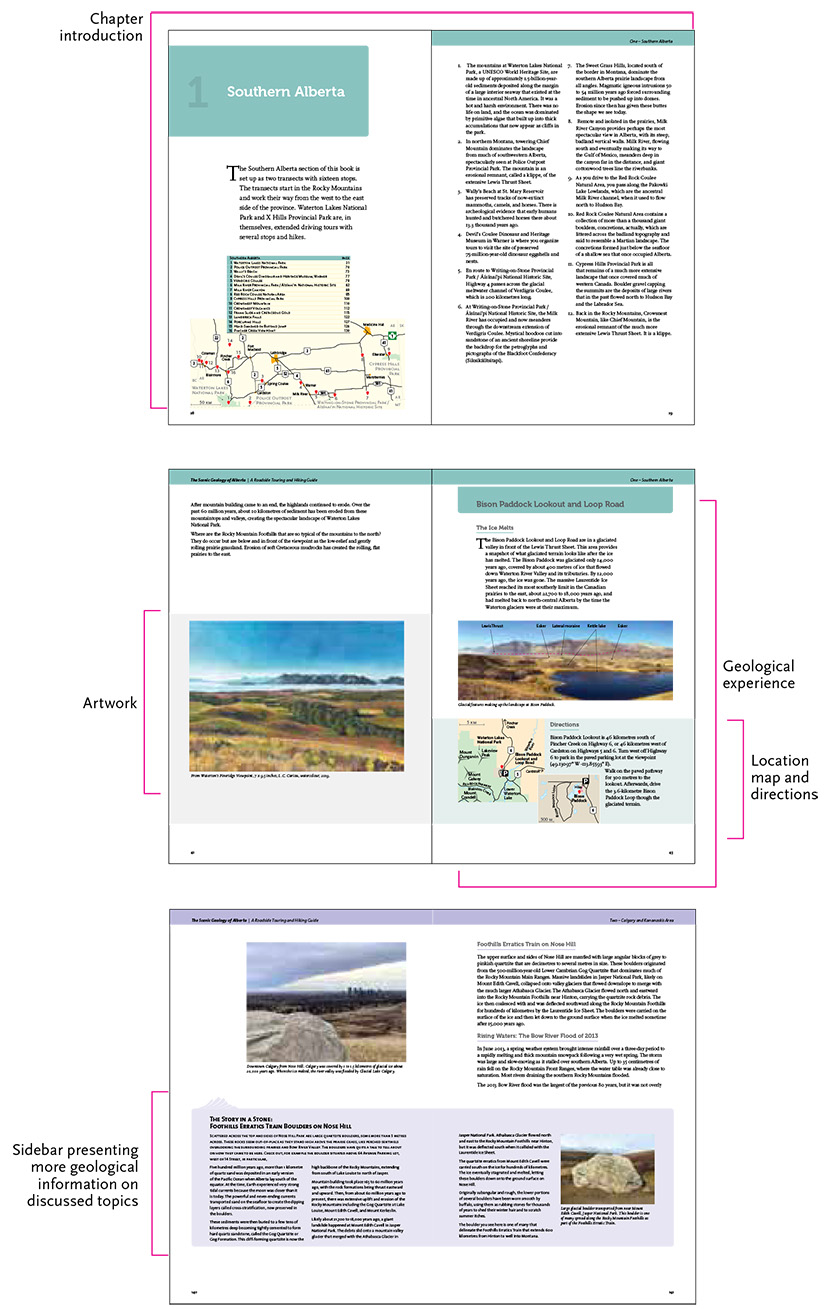
The geological stops. Visual example of how they appear in the book.
Organization of this Book
This roadside guide presents you, the traveller of Alberta, with suggestions for trips to informative and spectacular sites in the provinces Rocky Mountains, river valleys, prairies, and badlands.
The routes and stops follow the main highways and roads across Alberta. The geological stops are mostly at roadside pullouts, in parks, and at natural areas. The book includes road trips to scenic geological overviews at Waterton Lakes National Park, Cypress Hills, Dinosaur Provincial Park, and Elk Island National Park, and in Edmonton and Calgary, to name but a few. The individual route descriptions help you figure out how to arrive at the sites, where to park, and where to walk. Location maps are provided for each stop and include driving, parking, and walking directions.
Some stop descriptions also include sidebars that offer additional depth and geological or cultural information on topics discussed at the stop.
Trip Planner
This tour book is arranged to be used in several ways. You can use it to support your local and day trips, or for multi-day excursions. The localities described are situated across Alberta, and it could easily take two weeks to visit and appreciate all the stops described.
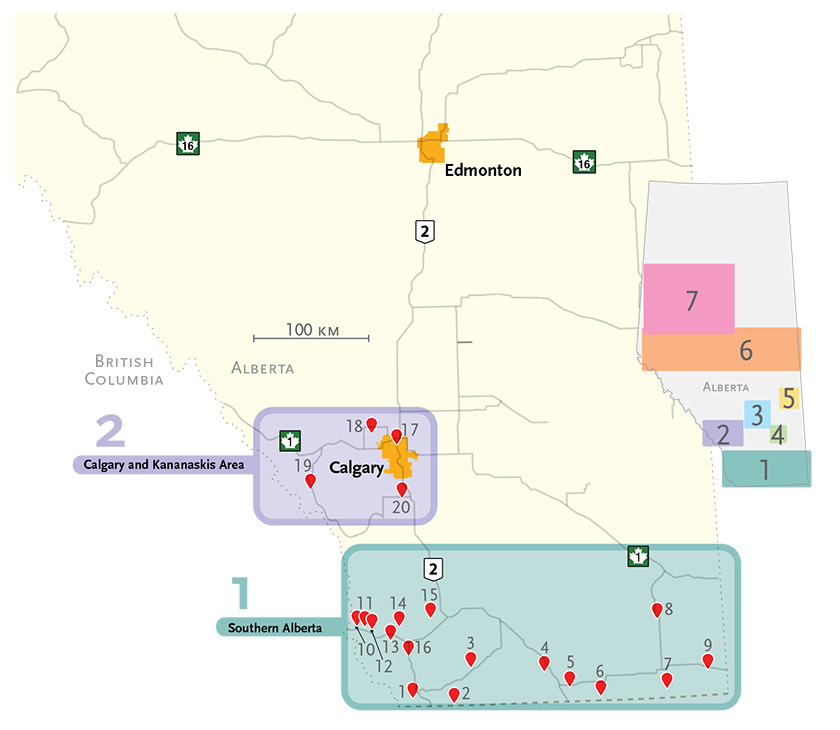
The geological stops are organized in seven subregions, covering most of the province:
1.Southern Alberta
2.Calgary and Kananaskis Area
3.Red Deer River Valley
4.Dinosaur Provincial Park
5.Disruption in the Prairies
6.Crossing Central Alberta
7.Checking Out the North
Before you set out, plan your trip and scenic geological experience at the various locations across Alberta. The trip planner summarizes features of the stops discussed in the book. The stops are listed in a practical travel order and colour coded according to the sections in which they occur. To take full advantage of the geological sites, I do suggest undertaking a hike at several stops. Distances are shown.
One Southern Alberta | page |
Point 1 | Waterton Lakes National Park Scenic Area | |
Geological Stops | Hike | Distance |
Pine Ridge Viewpoint | |
Bison Paddock Lookout and Loop Road | yes | 600 m (return) | |
Waterton River Valley Viewpoint | |
Waterton Lakes Overview | |
Mount Blakiston | |
Red Rock Canyon | yes | 600 m (loop trail) and 2.1 km (return) | |
Prince of Wales Hotel | |
Bears Hump | yes | 2.8 km (return) | |
Cameron Falls | yes | 440 m (return) | |
Cameron Creek Alluvial Fan | yes | 1.2 km (return) and 2.7 km (return) | |
Natural Oil Seeps Akamina Parkway | |
Cameron Lake | |
Point 2 | Police Outpost Provincial Park Scenic Area | |
Geological Stops | Hike | Distance |
Boundary Creek Trail | yes | 2.8 km (loop trail) | |
Point 3 | Wallys Beach at St. Mary Reservoir Scenic Area | |
Geological Stops | Hike | Distance |
Reservoir walk | yes | 3.2 km (return) | |
Point 4 | Devils Coulee Dinosaur and Heritage Museum, Warner Scenic Area | |
Geological Stops | Hike | Distance |
Devils Coulee | yes | 1 km (return) | |

