Andrew Weber
Starting with a life-changing trip to Cedar Mesa in the fall of 2001, Andrew Weber has spent two decades exploring the landscape and archaeology of the Four Corners region, including several years as a volunteer ranger at Kane Gulch. He has also worked at Mesa Verde National Park, helping to digitize the parks archaeological records, and served as an archaeological site steward in Canyons of the Ancients National Monument.
Working as a freelance journalist and photographer, Andrew has written about a wide range of topics, including cultural events, the arts, and professional sports. This is his third guidebook, after 60 Hikes Within 60 Miles: Seattle and Easy Hikes Close to Home: Seattle.
He currently resides on the Navajo Nation in the town of Shiprock, New Mexico, with his wife and two sons.
The first time I stepped into a Cedar Mesa canyon I was already working on this book, although no one knew it at the timeespecially not me. Thanks to everyone whos ever spent a day with me in the canyons over the years, including Dan Brady, Soren Bowie, Damian Costello, and Eric Barth. Im glad we got to share the adventure. Special thanks to Bryce Stevens, who was there right from the beginning and whos seen more of the canyon country with me than anyone. You never failed to remind me theres always a way, even when the route is hidden.
I owe a particular debt of gratitude to Laura Lantz and Scott Edwards at Kane Gulch f or giving me the opportunity to work as a volunteer ranger all those years ago. Its not everyones ambition to live in a trailer without running water in the middle of nowhere, but its something Ill never forget. Along with the entire staff of the BLM Monticello Field Office, you showed me how to serve something bigger than myself and what real dedication can achieve, despite a lack of resources, support, or funds. You were the very image of professionalism in the face of impossible circumstances.
Without Friends of Cedar Mesa, I would never have been involved in this project at all. Thanks to Josh Ewing, Amanda Podmore, Erica Tucker, and Stephanie Wacha for first recruiting me as an author and then answering all of my endless requests for materials and assistance. If this book helps your organization achieve any of its goals, I will consider it a runaway success.
Lastly, thanks to the entire crew at FalconGuides for shepherding this project across the finish line and launching it into the world. In particular, I couldnt have done it without my invaluable editors, Jess dArbonne, Katie ODell, and Lynn Zelem, who kept me on the trail when it would have been so easy to get lost in rock formations along the way.
Despite all the assistance I have received, any errors in the final copy are my responsibility alone. Additionally, although Friends of Cedar Mesa was involved in many aspects of the creation of this book, they did not review the text and are not responsible for any of its content.
THE GREAT SANDSTONE FIN OF COMB RIDGE STRETCHES MORE THAN 75 miles from the town of Kayenta, Arizona, to where it fades into the Abajo (Blue) Mountains in Utah at its northern end. Both a significant landmark for navigation and a substantial barrier to eastwest travel, the Comb is one of the most recognizable topographical features anywhere in Bears Ears. The trips in this section explore the rich archaeological heritage of the Combs many fissures, gaps, and clefts, as well as visit Butler Wash, the Combs major drainage channel to the east, which holds some treasures of its own.
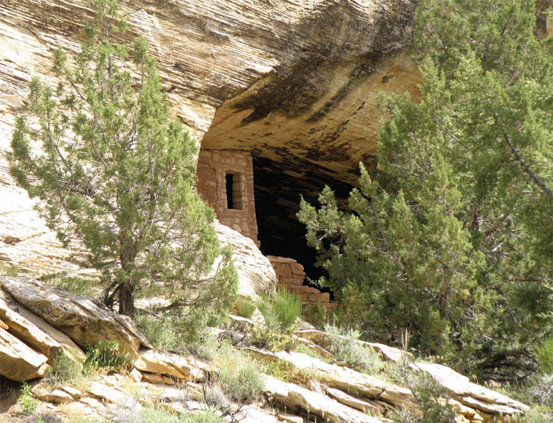
Ruin alcove near Fishmouth Cave.
An excellent rock art panel easily accessible just outside the town of Bluff.
Dont Touch Rock Imagery or Make Your Own
Visiting time: Up to 1 hour
Best season: Year-round
Canine compatibility: Leashed dogs allowed
Fees and permits: None
MAPS: USGS topo maps: Bluff, Utah; Other maps: National Geographic Trails Illustrated #706, Grand Gulch Cedar Mesa Plateau
Contacts: BLM Monticello Field Office, 365 N. Main, PO Box 7, Monticello, UT 84535, (435) 587-1500, www.blm.gov/office/monticello-field-office; Other: Sand Island Ranger Station, A Loop Road, Sand Island Campground
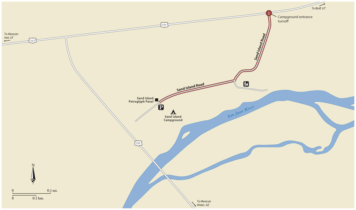
Finding the trailhead: From the town of Bluff, take Main Street/US 191 south for about 3 miles and turn left at the signed entrance to Sand Island Boat Launch and Campground. Enter the campground and then take the first right onto a gravel road, signed for Sand Island Petroglyph Panel. In about 0.3 mile, park at the information board on the right.
GPS coordinates: N37 15.71160' / W109 37.11420'
The Panel
For centuries people have accessed the San Juan River at Sand Island, currently home to a campground and boat launch. The car campers and river runners of today are walking in the footsteps of the Ancestral Puebloans, who marked the site with an extensive art panel, still visible on the rock. Some of the symbols displayed date back at least 3,000 years.
Look for the art along the sandstone wall directly behind the information board. Note that a fence runs along the base of the wall to keep viewers from touching or otherwise harming the display; please respect it. Regrettably, vandals have already applied modern graffiti in veral spots.
The petroglyphs start far up to the right, above a sloping sandstone ledge where the artists likely stood while they worked. But on the left, you will notice much of the art is now mysteriously out of reach. The ancient Puebloans must have climbed up somehow, although its hard to imagine with this approach how they would have had a free hand left for drawing, or even been able to effectively see their work.
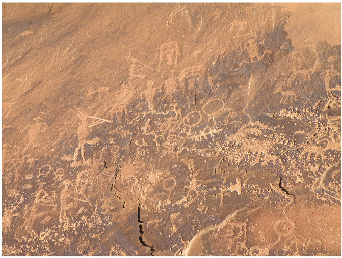
Ancient petroglyphs at Sand Island.
The entire panel exhibits a mix of concrete and abstract forms. Life-size handprints, bighorn sheep, and hunters with weapons sit next to spirals, dotted lines, and geometric patterns. Images are frequently crowded together or even overlapping, a layering known as superimposition.
These jumbled symbols and figures are hardly the work of a single artist, or even a single era. Some of the petroglyphs have been on the wall so long they have become revarnished. Others show evidence of repecking, a technique where later artists reemphasize the importance of an image long after its original creation.
The densest part of the panel features an artistic style common along the San Juan River known as San Juan Anthropomorphic. This style dates primarily from the early Basketmaker II period, roughly from 1500 BCE to 50 CE, when many archaeologists identify Ancestral Puebloan art as having reached its creative peak. Anthropomorph is a fancy word for person; one of the defining features of San Juan Anthropomorphic style
Sand Island Petroglyph Panel


