Fred Barstad - Hiking Oregons Eagle Cap Wilderness: A Guide to the Areas Greatest Hiking Adventures
Here you can read online Fred Barstad - Hiking Oregons Eagle Cap Wilderness: A Guide to the Areas Greatest Hiking Adventures full text of the book (entire story) in english for free. Download pdf and epub, get meaning, cover and reviews about this ebook. year: 2021, publisher: Falcon Guides, genre: Children. Description of the work, (preface) as well as reviews are available. Best literature library LitArk.com created for fans of good reading and offers a wide selection of genres:
Romance novel
Science fiction
Adventure
Detective
Science
History
Home and family
Prose
Art
Politics
Computer
Non-fiction
Religion
Business
Children
Humor
Choose a favorite category and find really read worthwhile books. Enjoy immersion in the world of imagination, feel the emotions of the characters or learn something new for yourself, make an fascinating discovery.

- Book:Hiking Oregons Eagle Cap Wilderness: A Guide to the Areas Greatest Hiking Adventures
- Author:
- Publisher:Falcon Guides
- Genre:
- Year:2021
- Rating:5 / 5
- Favourites:Add to favourites
- Your mark:
Hiking Oregons Eagle Cap Wilderness: A Guide to the Areas Greatest Hiking Adventures: summary, description and annotation
We offer to read an annotation, description, summary or preface (depends on what the author of the book "Hiking Oregons Eagle Cap Wilderness: A Guide to the Areas Greatest Hiking Adventures" wrote himself). If you haven't found the necessary information about the book — write in the comments, we will try to find it.
Fred Barstad: author's other books
Who wrote Hiking Oregons Eagle Cap Wilderness: A Guide to the Areas Greatest Hiking Adventures? Find out the surname, the name of the author of the book and a list of all author's works by series.
Hiking Oregons Eagle Cap Wilderness: A Guide to the Areas Greatest Hiking Adventures — read online for free the complete book (whole text) full work
Below is the text of the book, divided by pages. System saving the place of the last page read, allows you to conveniently read the book "Hiking Oregons Eagle Cap Wilderness: A Guide to the Areas Greatest Hiking Adventures" online for free, without having to search again every time where you left off. Put a bookmark, and you can go to the page where you finished reading at any time.
Font size:
Interval:
Bookmark:
A native Oregonian, Fred Barstad developed a keen interest in the remote high country of his state when he was young. As a teenager in the 1960s, Barstad roamed the Cascade Range in search of lakes to fish and peaks to climb. This search soon became an addiction for bagging peaks. Barstad has climbed all the major Cascade peaks in Oregon, many of them several times, including sixty-three climbs to the summit of Mount Hood.
Barstad eventually developed a desire to climb mountains outside of Oregon, which took him to Mount Rainier in Washington, 20,320-foot-high Mount McKinley in Alaska, Aconcagua in Argentina, and Popocatpetl and Citlaltpetl in Mexico.
Ever since he saw the Wallowa Mountains on a family vacation in 1961, Barstad has spent many years exploring, hunting, and fishing the canyons and peaks of this range. In 1987 he moved to Enterprise, Oregon, and began exploring the vast wild area of Eagle Cap Wilderness. He soon recognized a need for a guidebook to this spectacular area and eventually sold his business interest in the Wallowa Lake Marina to devote all of his attention to writing hiking books.
Barstad has hiked all the trails and routes featured in this book, nearly 1,500 miles worth. He hopes that Hiking Oregons Eagle Cap Wilderness will promote more interest in helping to preserve its pristine quality.
I would like to thank Gary Fletcher for hiking with me, contributing photos, and editing the text. I also want to thank Maria Forsenius, Kerry Searles, Lowell Euhus, Ettore Negri, Lance Reedy, and Jerry Lavender for hiking with me and furnishing pictures.
Thanks to Casey Barstad, Brian Barstad, Dan Knight, Doug Cracraft, Oliver Boeve, and Dave Kaufman for hiking and camping with me and keeping me company over many miles. Also of great help were Bill George, for hiking with me and sharing his knowledge of the area, and Vic Coggins, of the Oregon Department of Fish and Wildlife, for information on the bighorn sheep and mountain goats.
Thanks also to Larry Brandvold, John Hollendeak, Nancy Rudger, Sweyn Wall, and all the employees of USDA Forest Service at the Wallowa Mountains Office for much information on trail status and maintenance. Thanks to Bud Sanders for trail information. Most of all I thank my wife, Suzi Barstad, for hiking and camping with me, and for her endless hours of typing and editing to get this book ready for publication.
USDA Forest Service
Wallowa Mountains Office
201 E 2nd St. / PO Box 905
Joseph, OR 97846
(541) 426-5546; (541) 426-4978
www.fs.usda.gov/wallowa-whitman
USDA Forest Service
Pine Ranger Station, Pine Ranger District
General Delivery
Halfway, OR 97834
(541) 742-7511
www.fs.usda.gov/wallowa-whitman
For flights to the Horse Ranch or Minam Lodge
Spence Air Service
PO Box 217
Enterprise, OR 97828
(541) 426-3288
To help with trail maintenance
Wallowa Mountains Hells Canyon Trail Association (WMHCTA)
401 NE First St., Ste. A
Enterprise, OR 97828
www.wmhcta.org
E-mail:
Or visit on Facebook.
Wing Ridge Ski Tours
500 N River St.
Enterprise, OR 97828
(541) 398-1980; (888) 812-4707, ext. 3
www.facebook.com/Wing-Ridge-Ski-Tours-239313479446588
Blaze: A mark on a tree formed by cutting away a small section of bark with a hatchet or ax. There may be one or two marks. Blazes can usually be seen some distance ahead.
Braided trail: A section of trail formed by two or more interconnecting paths. Not to be confused with cattle trails, which do not necessarily return to the main trail.
Cairn: A stack or pile of rocks that marks the trail or route.
Cirque: A glacier-carved bowl in a mountain, usually at the head of a valley, canyon, or gully.
Clear-cut: An area that has been logged of all its timber.
Complete burn: An area where all the trees were killed by a forest fire.
Gully: A trench in the ground, smaller than a canyon. It may be steep and may or may not have a stream in it.
Jeep road: A road that is impassable for most two-wheel-drive vehicles. Roads may be blocked and closed to motor vehicles.
Notch: Naturally carved-out sections of a ridge, much smaller than a saddle, with rock outcroppings on both sides.
Outcropping: Bedrock protruding through the surface of the ground.
Partial burn: An area where a forest fire killed some, but not all, of the trees.
Pika: A small mammal that lives in steep, rocky areas or talus slopes. Pikas are related to rabbits and do not hibernate.
Red digger: A species of ground squirrel.
Ridgeline: The top of a ridge; may slope steeply.
Saddle: The low point of a ridge, usually gently sloping. Much larger than a notch.
Scree: Loose rock on a slope. Rocks in a scree slope are smaller than the rocks on a talus slope. May be tiring to climb.
Semi-switchback: A tight corner (120 degrees or less) in a trail.
Small stream: A stream 2 feet wide or less; smaller than a creek or stream. May dry up in late summer or fall.
Spur ridge: A smaller ridge protruding off the main ridge. May be quite steep.
Switchback: A tight corner (more than 120 degrees) in a trail where the trail turns back on itself as it traverses a hill. Allows hikers to negotiate steep slopes.
Talus slope: A slope covered with large rocks or boulders.
Tiny stream: A stream less than 1 foot wide. Usually dry in fall.
Traverse: The crossing of a slope, climbing or descending, but usually in a nearly straight line. This term is also used to describe a route or trail that follows a fairly flat ridgeline.
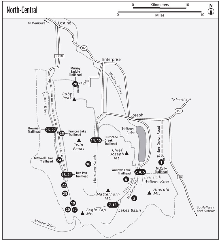
Backpack through the subalpine country of the McCully Basin, then climb over an 8,700-foot-high pass with views in all directions before descending to a junction with the Tenderfoot Wagon Road Trail. (Trail 1812)
Distance: 10.5 miles one way to Tenderfoot Trail (1819); 11.5 miles for a shuttle hike to the Tenderfoot Trailhead
Hiking time: 47 hours
Difficulty: Moderate
Trail maintenance: Yearly
Best season: Mid-June through mid-Oct for hiking; Dec through Mar for skiing. Some avalanche danger in winter.
Traffic and other trail users: Light foot and horse traffic, except during Oct and Nov hunting seasons, when it may be heavier; light ski traffic in winter
Canine compatibility: Dogs permitted without leashes, but must be kept away from the stock of other parties
Fees and permits: Northwest Forest Pass and Eagle Cap Wilderness Permit
Maximum elevation: 8,700 feet
Maps: USGS Joseph OR and Aneroid Mountain OR; Geo Graphics Wallowa Mountains Eagle Cap Wilderness
Trail contact: USDA Forest Service Wallowa Mountains Office, 201 E 2nd St. / PO Box 905, Joseph, OR 97846; (541) 426-5546, (541) 426-4978; www.fs.usda.gov/wallowa-whitman
Finding the trailhead: Go east from Joseph for 5.5 miles on the Imnaha Highway and turn right on Tucker Down Road. Go 4.7 miles and turn right on FR 012. Drive 0.5 mile and turn right into McCully Trailhead parking lot. A gate blocks FR 012 next to the trailhead parking lot.
GPS: N45 16.631' / W117 08.173'
The trail leaves the trailhead next to the restroom (5,700 ft.), but soon rejoins closed FR 012. Back on the roadbed, continue south for 0.8 mile to the Old McCully Trailhead, where the trail leaves the area that burned in 1988 in the Canal Fire. Be careful not to take the Mount Howard Trail, an unused jeep road that switches back to the right 0.5 mile after leaving the McCully Trailhead.
Font size:
Interval:
Bookmark:
Similar books «Hiking Oregons Eagle Cap Wilderness: A Guide to the Areas Greatest Hiking Adventures»
Look at similar books to Hiking Oregons Eagle Cap Wilderness: A Guide to the Areas Greatest Hiking Adventures. We have selected literature similar in name and meaning in the hope of providing readers with more options to find new, interesting, not yet read works.
Discussion, reviews of the book Hiking Oregons Eagle Cap Wilderness: A Guide to the Areas Greatest Hiking Adventures and just readers' own opinions. Leave your comments, write what you think about the work, its meaning or the main characters. Specify what exactly you liked and what you didn't like, and why you think so.