Bloomsbury Natural History
An imprint of Bloomsbury Publishing Plc
| 50 Bedford Square | 1385 Broadway |
| London | New York |
| WC1B 3DP | NY 10018 |
| UK | USA |
www.bloomsbury.com
Bloomsbury is a trademark of Bloomsbury Publishing Plc
This electronic edition published in 2015 by Bloomsbury Publishing Plc
First by New Holland Publishers (UK) Ltd in 2002
This edition published by Bloomsbury in 2015
Lawson Wood, 2012
Line drawings Mick Loates, 2002
Cartography Carte Blanche, Paignton, 2002
Lawson Wood has asserted his right under the Copyright, Designs and Patents Act, 1988, to be identified as Author of this work.
All rights reserved
You may not copy, distribute, transmit, reproduce or otherwise make available this publication (or any part of it) in any form, or by any means (including without limitation electronic, digital, optical, mechanical, photocopying, printing, recording or otherwise), without the prior written permission of the publisher. Any person who does any unauthorised act in relation to this publication may be liable to criminal prosecution and civil claims for damages.
A catalogue record for this book is available from the British Library.
Library of Congress Cataloguing-in-Publication data has been applied for.
ISBN: PB: 978-1-4729-2178-9
ePDF: 978-1-4729-2177-2
ePub: 978-1-4729-2176-5
To find out more about our authors and books visit www.bloomsbury.com. Here you will find extracts, author interviews, details of forthcoming events and the option to sign up for our newsletters.
Acknowledgements
Many thanks to the many people and organizations who made this project possible and in particular: Lesley Orson; Jo Hemmings; Helmut Debelius; Dr. Elizabeth Wood; Professor Alexandre Meinesz and the University of Nice; Mark Busuttil and St. Andrews Divers Cove, Gozo; George Vella and Calypso Diving Centre, Gozo; Ian Pitchfork and Aquaventure, Malta; Mike & Agnes Upton at Maltaqua, Malta; Mike Mandale, Ramon Sileceo and Xaloc Dive Centre, Estartit, Spain; Mark & Diana Davies, Valbonne, France; Pantxoa and Madame Gabi at Aqua Pro Dive International, Villefranche-sur-Mer, France; Igor Indjein from Golf Juan, France; Michle Tourrette of Telemaque Plon-gee, Roquebrune, France; Fred Short and Rock Marine, Gibraltar; Photos Socratous and Cydive, Cyprus; Guido Schwengersbauer and Posejdon Croatia Diving Club, Croatia; Eurodivers, Zakynthos, Greece; Loisirs de Tabarka Dive Centre, Tunisia; Alf Chappell and the European Diving Centre, Turkey; Mansour and the Extreme Team Diving Club in the Lebanon; Hugh and Sardinia Scuba Tours, Sardinia; Marine Conservation Society; The Shark Group; Sea & Sea Ltd; Alan James Photography; Ocean Optics; Eastern Photovisual; Harlequin Worldwide Travel; Snooba Travel; British Airways; Air Malta; Go; Ryanair and Easyjet.
CONTENTS
THE MEDITERRANEAN
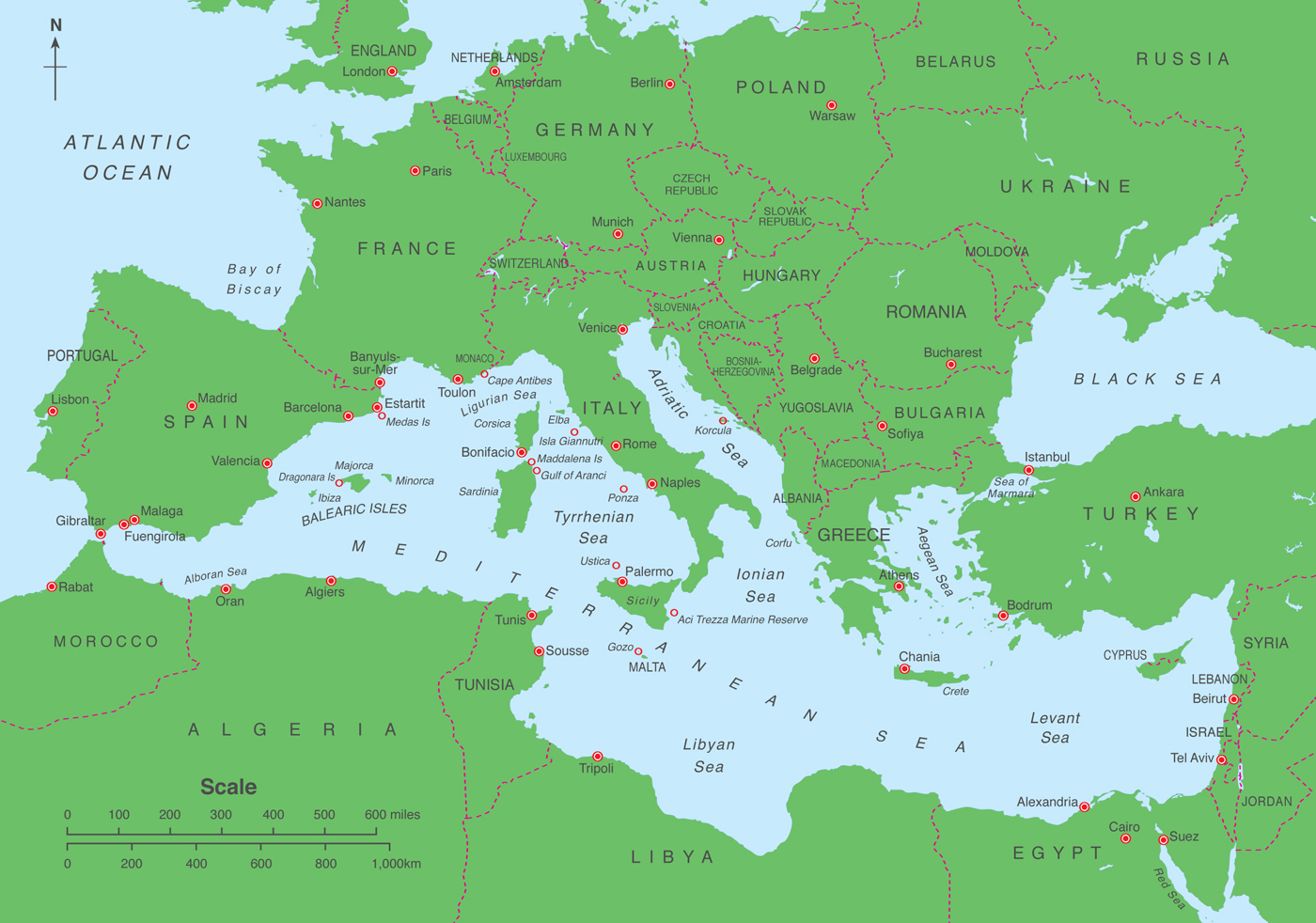
Known as the Cradle of Civilization, the Mediterranean Sea is now set in a massive flooded depression in the earths crust formed over millennia. This vast expanse of water is almost completely landlocked, stretching from the Straits of Gibraltar in the west to the coasts of Turkey, Syria and Israel in the East. The Mediterranean both links and divides three continents, Europe, Africa and Asia. The varied depths of this basin also support varying communities of marine life and although all of the species found in the Mediterranean contribute to the whole, we shall only concern ourselves with what we can see, practically and with the least effort, whether it be from swimming, snorkelling, scuba diving, or even fishing and sailing.
With water temperatures that never drop below 10C, the Mediterranean has remained fairly isolated over the years and has evolved a distinct ecosystem only troubled by mans intrusion. The region is complex and diverse in its geography, history and climate, with much of what we know and see only coming from the northern shores and around many of the islands.
Known for its very singular climate, the present shores of the Mediterranean were roughly formed five million years ago; however, it took early form over twenty million years ago when the western shores were still closed and the eastern end was still linked to the vast primeval Tethys Sea. As the years passed, Africa slipped anticlockwise, Arabia split from Africa forming the Red Sea and the eastern stretches of the Mediterranean also became landlocked. Whilst this continental movement was progressing, the land areas were gradually crumpled up forming a ring of mountains which now comprise the Sierra Nevada, the Alps, the Atlas Mountains, the Dinaric Alps, the Rhodope Mountains, the Akhdar Heights and the Taurus Mountains. Over the subsequent two or three million years, the now-landlocked Mediterranean filled and evaporated several times as the earths crust shifted, often leaving gigantic salt marshes and mud pools where dinosaurs once roamed.
As far as can be agreed between scientists, about five million years ago, there was a massive cataclysmic earthquake which opened up the Gibraltar sill, and the Atlantic Ocean poured into the basin taking almost a century to fill. Today, this connection to the Atlantic Ocean is still very evident and water pours into the Mediterranean at approximately 4km/h (2.5mph) in a layer from 75 to 300m (2501,000ft) deep. This sea water gradually evaporates and the heavier, more salty water sinks and eventually flows back out through the Straits of Gibraltar, taking around eighty years to replenish the water column.
This has had several knock-on effects, one of which is the reduced amount of plankton to be found in the Mediterranean and what plankton there is, quite often flows back out into the Atlantic in the deeper ocean currents. This ultimately produces less marine life, but also clear water in general. As always, there are notable exceptions and wherever there is a large river run-off there will be periodic algal blooms which reduce visibility. Rough seas in shallow areas also contribute to poor visibility, but in general one should expect underwater visibility of about 30 to 50m (100165ft).
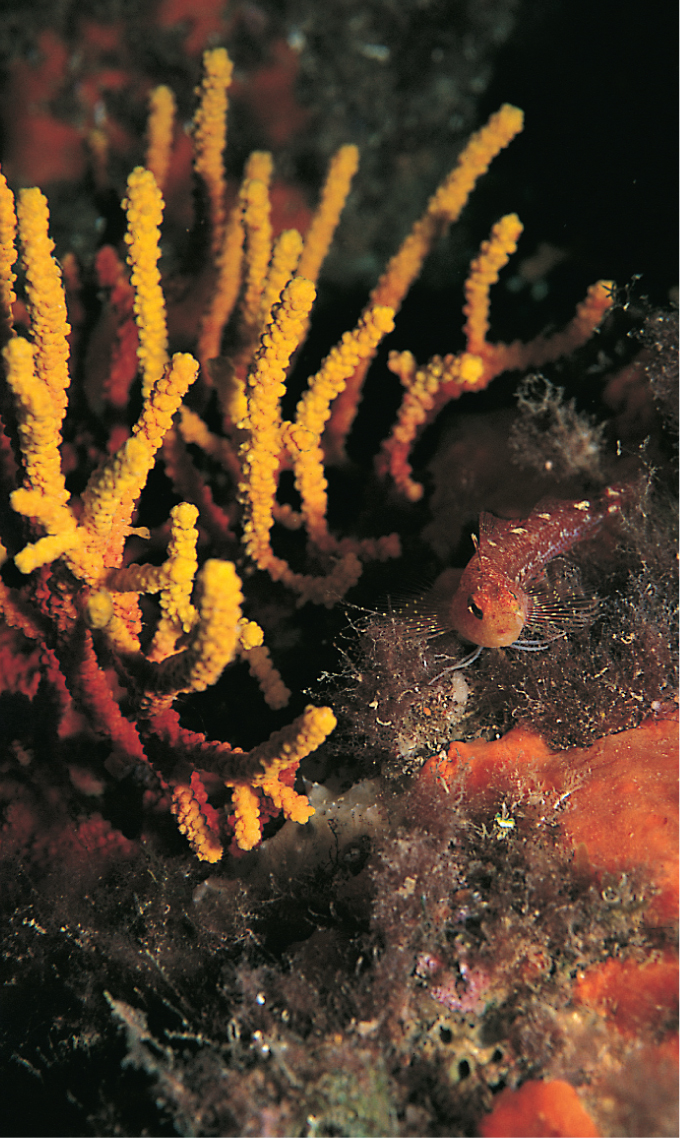
Colourful corals can be found all around the Mediterranean coastline and offshore islands.
A Sea of Seas
Although not truly one sea, but several joined together, the individual seas are defined by the surrounding land masses formed when the earths crust collided. There are two principal areas known as the Eastern and Western Mediterranean roughly separated by the mid-ocean ridge which runs from Italy to the African coast. The Alboran Sea is found in the west, connecting to the Algerian Sea or Balearic Basin between Algeria, Sardinia, Spain and France. The Gulf of Lyons and the Ligurian Sea stretch along the southern coast of France, the Tyrrhenian Sea surrounded by Corsica and Sardinia to the west, Italy to the east and Sicily to the south. The two most famous of the Mediterraneans seas are the Adriatic and the Aegean; it is on these seas that the history of mankind spread from the old to the new worlds. The Gulf of Trieste, in the northern area of the Adriatic Sea, is formed with Italy on its west, Croatia and Albania to its east; further south the Ionian Sea separates the southern coasts of Italy and Sicily with the Maltese islands to the west with Greece and its many islands to the east. Separating Greece and Turkey is the Aegean Sea which is connected to the Black Sea in the north-east by the Dardanelles, Sea of Marmara and the Bosporus. In the eastern reaches can be found the Levant Sea bordered by Turkey and the islands of Crete and Cyprus to the north and Syria, the Lebanon and Israel to the east, with Egypt and Libya to the south. The Ionian Sea and the Levant Sea are roughly divided by a shallow stretch of water sometimes referred to as the Libyan Sea. The Ionian basin is the deepest part of the Mediterranean at 5,121m (17,000ft). In Egypt, of course, can be found the man-made Suez Canal, opened in 1869, which links the Mediterranean with the Red Sea.

