Robert I. Egbert - The GPS Handbook: A Guide for the Outdoors
Here you can read online Robert I. Egbert - The GPS Handbook: A Guide for the Outdoors full text of the book (entire story) in english for free. Download pdf and epub, get meaning, cover and reviews about this ebook. year: 2012, publisher: Burford Books, genre: Children. Description of the work, (preface) as well as reviews are available. Best literature library LitArk.com created for fans of good reading and offers a wide selection of genres:
Romance novel
Science fiction
Adventure
Detective
Science
History
Home and family
Prose
Art
Politics
Computer
Non-fiction
Religion
Business
Children
Humor
Choose a favorite category and find really read worthwhile books. Enjoy immersion in the world of imagination, feel the emotions of the characters or learn something new for yourself, make an fascinating discovery.

- Book:The GPS Handbook: A Guide for the Outdoors
- Author:
- Publisher:Burford Books
- Genre:
- Year:2012
- Rating:4 / 5
- Favourites:Add to favourites
- Your mark:
The GPS Handbook: A Guide for the Outdoors: summary, description and annotation
We offer to read an annotation, description, summary or preface (depends on what the author of the book "The GPS Handbook: A Guide for the Outdoors" wrote himself). If you haven't found the necessary information about the book — write in the comments, we will try to find it.
Updated with information on the latest models of GPS and new technology such as sophisticated downloadable maps, this new edition provides all the information needed to work any GPS unit in the outdoors.
Robert I. Egbert: author's other books
Who wrote The GPS Handbook: A Guide for the Outdoors? Find out the surname, the name of the author of the book and a list of all author's works by series.


The GPS Handbook: A Guide for the Outdoors — read online for free the complete book (whole text) full work
Below is the text of the book, divided by pages. System saving the place of the last page read, allows you to conveniently read the book "The GPS Handbook: A Guide for the Outdoors" online for free, without having to search again every time where you left off. Put a bookmark, and you can go to the page where you finished reading at any time.
Font size:
Interval:
Bookmark:
 | Bibliography |
Hjellstrom, Bjorn, Be Expert with Map and Compass , John Wiley & Sons, 1994.
U.S. Department of Defense, U.S. Army Survival Manual FM 21-76 .
| Useful Web Sites |
T he ever-evolving World Wide Web provides a vast treasure trove of GPS, map, and land navigation information.
Some sites were noted in the text; other interesting sites are listed below. For additional information on a specific topic, use a good search engine like Google. Its amazing how much information you can find on the Web with a bit of digging.
http://www.garmin.com/
http://www.lowrance.com/
http://www.delorme.com/
http://leadtek.com/
http://www.maptech.com/products/PocketNavigator/index.cfm
http://www.thegpsstore.com
http://www.gps4fun.com
http://www.esri.com/software/arcpad/index.html
http://www.delorme.com/
http://www.fugawi.com
http://www.cgrer.uiowa.edu/servers/servers_references.html
http://www.gpsworld.com/
http://www.geocaching.com/
http://www.windows.ucar.edu/tour/link=/earth/statistics.html
http://www.colorado.edu/geography/gcraft/notes/gps/gps.html
http://www.instant-power.com/sales/online_sales.shtml
http://www.teletype.com/pages/gps/compatibility.html
http://www.unc.edu/~rowlett/units/index.html
http://www.tapr.org/~kh2z/Waypoint/
 | An Introduction to GPS |
I n order to make the best use of a GPS, it is important to have at least a basic understanding of the way it works. This chapter gives an overview of the Global Positioning System, describes how it operates, and explains how it can be used to determine a precise location anywhere on earth.
The idea of a Global Positioning System or GPS was conceived in the 1970s by the U.S. Department of Defense (DoD). The original motivation behind the development of the system was the need for ballistic missile submarines to accurately determine their position before launching missiles. The other positioning systems available at that time were limited in range, too complicated, affected by atmospheric conditions, or subject to jamming and interference.
The backbone of the GPS system is a constellation of 24 NAVSTAR satellites located in precise orbits, each approximately 10,900 miles above the earth. These satellites were launched by the DoD at a cost of $12 billion. Each satellite weights about 4,000 pounds and is approximately 17 feet long with its solar panels extended. The satellites orbit the earth every 12 hours. They have an estimated life of seven and a half years each, but the system will be maintained, and new replacement satellites are planned.
In addition to the 24 GPS satellites, five ground stations monitor the satellites to make sure that they operate correctly and maintain their exact position in space. The ground stations are located in Hawaii, Ascension Island, Diego Garcia, Kwajalein, and Colorado Springs.
Each GPS satellite contains a high-frequency radio transmitter that sends information back to earth. A GPS receiver locks on to these signals, and by a process known as triangulationwhich will be discussed in more detail shortlycan accurately determine its location anywhere on earth. GPS operates 24 hours a day and in all weather conditions. This allows GPS to be used for precise navigation on land, on water, and in the air.
The concepts behind the operation of the GPS are relatively simple, although the electronics required are quite sophisticated. Basically, a GPS receiver determines position by calculating the distance to three or more of the GPS satellites by a process loosely referred to as triangulation .
For example, lets assume that we find ourselves at a point in space 11,000 miles from a particular GPS satellite. This would mean that we could be located at any point on the surface of a sphere with a radius of 11,000 miles that is centered on the particular GPS satellite (see illustration). Next, suppose that we determine the distance from our (as-yet-unknown) location to a second GPS satellite and find that this distance is 12,000 miles. This implies that we are also located on the surface of a second sphere with a radius of 12,000 miles centered on the second satellite. Now we can see that we must be located somewhere on the circle that is defined by where the two spheres intersect. If we calculate the distance between our location and a third satellite and find that this distance is, say, 13,000 miles, then using the same logic as before we find that we must be located on either one of the two points defined by the intersection of the three spheres. Usually one of these two points can be eliminated as a possible location because it is unrealistically far from the earth, or for other reasons. However, we can determine our true location without any guesswork by measuring the distance to a fourth GPS satellite. As we will see later, there is also another advantage in using a fourth measurement.
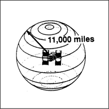
We are somewhere on this sphere.
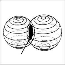
A second satellite narrows down our location.
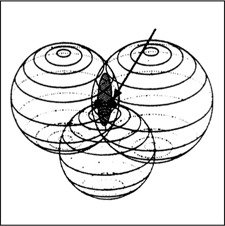
A third satellite puts us at either of two points. Courtesy Timble.
All this may seem well and goodbut how do we determine the (generally large) distances between our unknown location and the GPS satellites? Rather than measuring these distances directly, which would be a challenge, a GPS receiver measures the time it takes for the radio signal transmitted from each satellite to reach the location of the receiver. Since radio waves travel at the speed of light, which is roughly 186,000 miles per second, by measuring the time it takes for the signal from each satellite to travel to the receiver, the distance from the receiver to the satellite can be calculated by multiplying the travel time by the speed of the radio waves. We use the same process when we determine that an automobile traveling at 50 miles per hour for 3 hours travels 150 miles (50 miles/hour 3 hours = 150 miles).
At this point, it may seem that we have just traded one difficult problem for another. While measuring the distance from an unknown point to a satellite in space may seem complex, determining the time it takes for a signal traveling at 186,000 miles per second to cross that distance is obviously going to require a very accurate stopwatch. Even if the satellite is 15,000 miles from the GPS receiver, it will take only a little more than 0.08 seconds for the signal to reach the receiver.
Time measurement this accurate is accomplished by having each satellite generate its own unique signal, which is also stored in the GPS receiver. The receiver essentially compares the internal signal with the one received from the satellitewhich of course is delayed, since it has had to travel some 11,000 miles or more to reach the receiver. The time difference between a certain signal value in the internal signal and the same value in the delayed satellite signal is equal to the travel time. If we multiply this time difference by the speed of the radio wave, we obtain the distance.
Font size:
Interval:
Bookmark:
Similar books «The GPS Handbook: A Guide for the Outdoors»
Look at similar books to The GPS Handbook: A Guide for the Outdoors. We have selected literature similar in name and meaning in the hope of providing readers with more options to find new, interesting, not yet read works.
Discussion, reviews of the book The GPS Handbook: A Guide for the Outdoors and just readers' own opinions. Leave your comments, write what you think about the work, its meaning or the main characters. Specify what exactly you liked and what you didn't like, and why you think so.