Kay Robertson - Stem Guides To Maps
Here you can read online Kay Robertson - Stem Guides To Maps full text of the book (entire story) in english for free. Download pdf and epub, get meaning, cover and reviews about this ebook. year: 2013, publisher: Rourke Educational Media, genre: Children. Description of the work, (preface) as well as reviews are available. Best literature library LitArk.com created for fans of good reading and offers a wide selection of genres:
Romance novel
Science fiction
Adventure
Detective
Science
History
Home and family
Prose
Art
Politics
Computer
Non-fiction
Religion
Business
Children
Humor
Choose a favorite category and find really read worthwhile books. Enjoy immersion in the world of imagination, feel the emotions of the characters or learn something new for yourself, make an fascinating discovery.
- Book:Stem Guides To Maps
- Author:
- Publisher:Rourke Educational Media
- Genre:
- Year:2013
- Rating:5 / 5
- Favourites:Add to favourites
- Your mark:
Stem Guides To Maps: summary, description and annotation
We offer to read an annotation, description, summary or preface (depends on what the author of the book "Stem Guides To Maps" wrote himself). If you haven't found the necessary information about the book — write in the comments, we will try to find it.
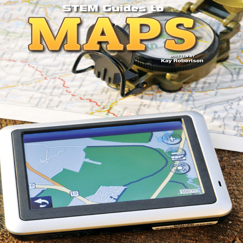
When was the last time you used a map to get somewhere? Did you know that maps depend on math for their accuracy? The details on a map have to be precise and math guarantees this precision. This STEM title guides students through real-world math problems while teaching the science and math behind creating maps known as cartography.
Kay Robertson: author's other books
Who wrote Stem Guides To Maps? Find out the surname, the name of the author of the book and a list of all author's works by series.


Stem Guides To Maps — read online for free the complete book (whole text) full work
Below is the text of the book, divided by pages. System saving the place of the last page read, allows you to conveniently read the book "Stem Guides To Maps" online for free, without having to search again every time where you left off. Put a bookmark, and you can go to the page where you finished reading at any time.
Font size:
Interval:
Bookmark:
| What does a compass show? | |
| Explain how lines of latitude and longitude work. | |
| What does a cartographer create? | |
| Which civilization developed the system of degrees for measurement? | |
| Describe the things a map legend might show. |
Photos of New York taken from above dont look much like maps. The streets arent labeled. Roads are not highlighted and places of interest are not identified. 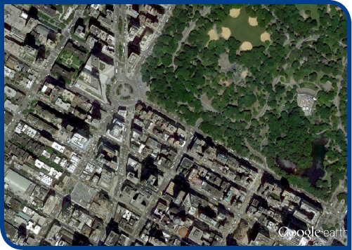 A topographic photo showing the southwest corner of New York Citys Central Park. , direction, or elevation. Calculating distance is one of the most common uses for a map.
Maps make this an easy task because they are drawn to scale. But what does drawn to scale mean? Essentially, it means that the place the map shows is a different size than the map. This is done for practical reasons. A map of the United States that was the exact same size of the United States wouldnt be very useful. To start with, you wouldnt be able to store it anywhere! Instead, people rely on maps that depict large areas on a smaller scale.  A road map showing the southwest corner of New York Citys Central Park. A road map showing the southwest corner of New York Citys Central Park.
STEM in Action ? Have you ever wondered how big the United States is? You can find out by using a map. Your map of the United States might use a different scale, but for the purposes of this example, imagine that the scale of the map is 1 inch equals 150 miles. Using a ruler, find out how many inches there are between the West Coast of the United States and the East Coast. Your map might be different, but in this case, lets say there are about 18 inches from the West Coast to the East Coast. To convert this distance from inches to miles, all you have to do is multiply the number of inches by the scale: 18 150 = 2,700 So the United States is about 2,700 miles across! Now that you know the distance across the United States, what about the distance from top to bottom? This is a little trickier than measuring the distance across, because this time there isnt a specific stopping point like the Atlantic and Pacific oceans. 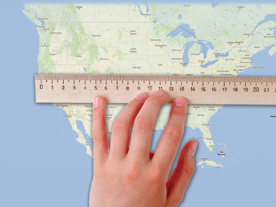 STEM in Action ? Now that you have those two calculations, you can calculate the of the United States. STEM in Action ? Now that you have those two calculations, you can calculate the of the United States.
That is to say, the measure of the total land mass. To calculate this figure, you need to multiply the distance across by the distance from top to bottom. The results will be in square miles: 2,700 1,575 = 4,252,500 So the total area of the United States is about 4,252,500 square miles! To make things simpler, you can also round that number down and say that the total area of the United States is about 4 million square miles. As you can see, maps are very useful for measuring distances, which is why they come in handy when planning a trip. is another reason why maps are so useful. Its good to know how far away your destination is when you begin a trip.
But unless you know what direction to travel in, you might as well stay home. 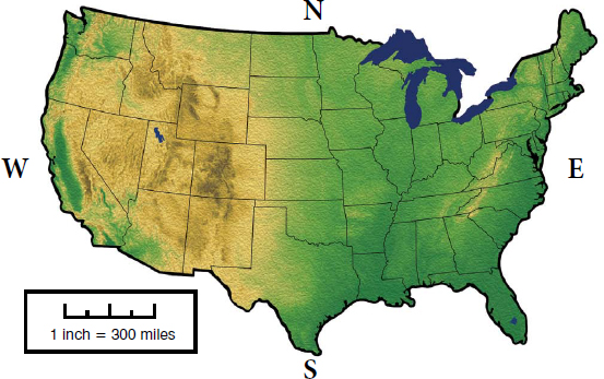 STEM Fast Fact ! Legends Very detailed maps often come with . A legend is a box on the map, usually placed in one of the corners, that explains what the symbols or icons on the map mean. Some standard map icons include:
  The letter H represents a hospital
  An airplane represents an airport
  A tent repsresent a campground Can you think of other symbols that might appear on a map legend and what they would stand for?
 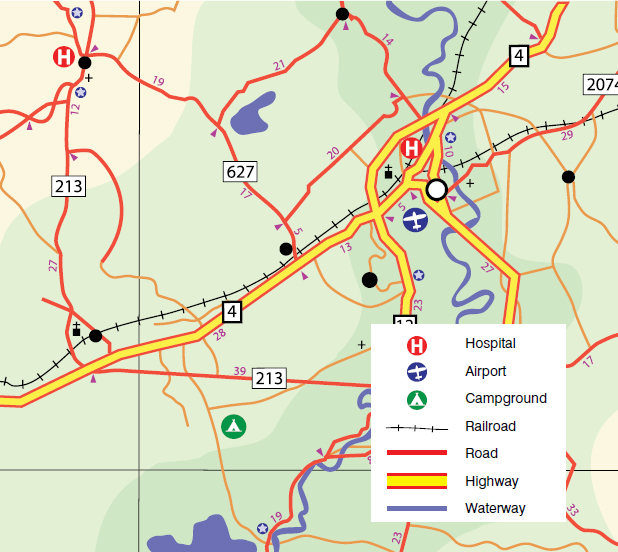 Using a Compass Did you know that the Earth is a giant magnet? Like a magnet, the Earth has a North Pole and South Pole. The North Pole is called the Arctic. The South Pole, on the other hand, is called Antarctica.
It is because of Earths magnetic properties that people can use compasses. With the right map and a compass, you can find your way just about anywhere in the world. 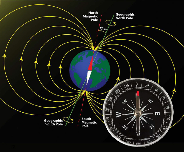 A compass is an instrument that you are probably already familiar with, even if you do not know how it works. A compass is a magnet. More specifically, the directional needle on a compass is a magnet. One end of the needle is usually painted.
The needle turns in reaction to the Earths magnetism and the painted end always points north. STEM in Action ? A typical compass indicates the four basic directions: N North S South E East W West These directions always point in the same way: North Top South Bottom East Right West Left With north defined by the compass needle, you can also determine which direction is south, east, or west.  of direction. Degrees are a unit of measurement developed by the ancient Greeks. They divide a circle into 360 portions, or degrees.
 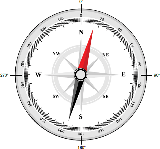 STEM Fast Fact ! What are the degree markings on a compass? North - 0East - 90South - 180West - 270 The difference in degrees between each of the four directions is exactly 90 degrees.
Font size:
Interval:
Bookmark:
Similar books «Stem Guides To Maps»
Look at similar books to Stem Guides To Maps. We have selected literature similar in name and meaning in the hope of providing readers with more options to find new, interesting, not yet read works.
Discussion, reviews of the book Stem Guides To Maps and just readers' own opinions. Leave your comments, write what you think about the work, its meaning or the main characters. Specify what exactly you liked and what you didn't like, and why you think so.