
Esri Press, 380 New York Street, Redlands, California 92373-8100
Copyright 2015 Esri
All rights reserved.
Printed in the United States of America
19 18 17 16 15 1 2 3 4 5 6 7 8 9 10
The information contained in this document is the exclusive property of Esri unless otherwise noted. This work is protected under United States copyright law and the copyright laws of the given countries of origin and applicable international laws, treaties, and/or conventions. No part of this work may be reproduced or transmitted in any form or by any means, electronic or mechanical, including photocopying or recording, or by any information storage or retrieval system, except as expressly permitted in writing by Esri. All requests should be sent to Attention: Contracts and Legal Services Manager, Esri, 380 New York Street, Redlands, California 92373-8100, USA.
The information contained in this document is subject to change without notice.
US Government Restricted/Limited Rights: Any software, documentation, and/or data delivered hereunder is subject to the terms of the License Agreement. The commercial license rights in the License Agreement strictly govern Licensees use, reproduction, or disclosure of the software, data, and documentation. In no event shall the US Government acquire greater than RESTRICTED/LIMITED RIGHTS. At a minimum, use, duplication, or disclosure by the US Government is subject to restrictions as set forth in FAR 52.227-14 Alternates I, II, and III (DEC 2007); FAR 52.227-19(b) (DEC 2007) and/or FAR 12.211/12.212 (Commercial Technical Data/Computer Software); and DFARS 252.227-7015 (DEC 2011) (Technical Data Commercial Items) and/or DFARS 227.7202 (Commercial Computer Software and Commercial Computer Software Documentation), as applicable. Contractor/Manufacturer is Esri, 380 New York Street, Redlands, CA 92373-8100, USA.
, GIS for Everyone, JTX, MapIt, Maplex, MapObjects, MapStudio, ModelBuilder, MOLE, MPSAtlas, PLTS, Rent-a-Tech, SDE, SML, SourcebookAmerica, SpatiaLABS, Spatial Database Engine, StreetMap, Tapestry, the ARC/INFO logo, the ArcGIS Explorer logo, the ArcGIS logo, the ArcPad logo, the Esri globe logo, the Esri Press logo, The Geographic Advantage, The Geographic Approach, the GIS Day logo, the MapIt logo, The Worlds Leading Desktop GIS, Water Writes, and Your Personal Geographic Information System are trademarks, service marks, or registered marks of Esri in the United States, the European Community, or certain other jurisdictions. CityEngine is a registered trademark of Procedural AG and is distributed under license by Esri. Other companies and products or services mentioned herein may be trademarks, service marks, or registered marks of their respective mark owners.
Ask for Esri Press titles at your local bookstore or order by calling 800-447-9778, or shop online at esri.com/esripress . Outside the United States, contact your local Esri distributor or shop online at eurospanbookstore.com/esri .
Esri Press titles are distributed to the trade by the following:
In North America:
Ingram Publisher Services
Toll-free telephone: 800-648-3104
Toll-free fax: 800-838-1149
E-mail:
In the United Kingdom, Europe, Middle East and Africa, Asia, and Australia:
Eurospan Group
3 Henrietta Street
London WC2E 8LU
United Kingdom
Telephone: 44(0) 1767 604972
Fax: 44(0) 1767 601640
E-mail:
142394
Contents
Preface
The new ArcGIS is a web GIS
By any measure, it is an exciting time to be working and engaged in the GIS field. Web GIS is emerging, and it is extending the reach of GIS.
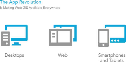
ArcGIS has grown to become a web GIS platform that you can use to deliver authoritative maps, analytics, and geographic information to a wider audience, using lightweight clients and custom applications on the web and smart devices.
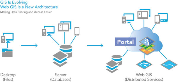
Virtually anyone can use web GIS to find, use, create, and share maps, perform GIS analysis, collaborate with others in groups and communities, and deploy easy-to-configure map-based applications for many extra users.
A living atlas of beautiful basemaps, imagery, and enabling geographic information is built into this platform. It is available for anyone to use, along with thousands of datasets and map services that have been shared and registered in ArcGIS by users like you from around the world.
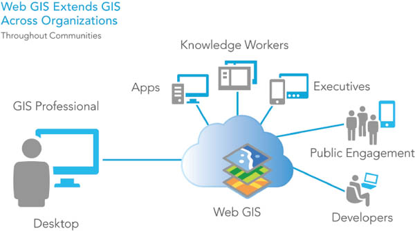
The new ArcGIS provides an online infrastructure for making maps and geographic information available throughout an organization, across a community, and openly on the web. This new vision for web GIS fully complements, integrates, and extends the existing professional GIS workflows with which you are already familiar.
This book will begin your journey to begin to learn about, understand, and apply web GIS.
What this book covers
Getting to Know Web GIS is a workbook, with detailed, step-by-step exercises, that teaches readers how to share resources online and build web GIS applications easily and quickly. It is a practical manual for classroom lab work and on-the-job training for GIS students, instructors, GIS analysts, managers, web developers, and a broad range of GIS professionals. It covers the Esri suite of web GIS technologies, including ArcGIS Online, Portal for ArcGIS, ArcGIS for Server, web app templates, Web AppBuilder for ArcGIS, ArcGIS API for JavaScript, the Collector for ArcGIS mobile app, ArcGIS Runtime SDKs for Mobile, Esri CityEngine, and 3D web scenes.
The sample data for this book and a 60-day trial of ArcGIS for Desktop software are available on the Esri Press book resource page at esripress.esri.com/bookresources .
Web GIS is a promising field with great applicability to e-government, e-business, e-science, and daily life. The societal need for both the web and GIS has generated a strong and increasing demand for good web GIS professionals. Professors need a lab book to teach this course, and on-the-job professionals need a guide to teach themselves. This book fits the need. In writing this book, I have tried to keep these provisions in mind and make it
easy to apply. Web GIS is quite a technical field, but you do not have to be a developer to build web apps. This book facilitates immediate productivity. It teaches you how to build engaging web apps without a single line of programming. Even the two chapters involving programming are designed to be easy to follow and do not require a strong programming background.
current. Web GIS technologies advance rapidly. The book teaches state-of-the-art technical skills for building applications and managing projects.
holistic. Unlike books that focus on individual products, this book teaches web GIS technologies as a holistic platform, from the server side to the browser, mobile, and desktop client side. This book also addresses the pros and cons of the available development options and helps you make the best choices based on your requirements and resources.
Next page

