PRAISE FOR THE RIVER
a moving and sadly accurate description of Australias greatest river system.
The Age
Timely and revealing an immensely readable travelogue, reveling in the rich heritage and character of the Australian bush.
Australian Bookseller & Publisher
[Hammers] clear-eyed analysis of the environmental issues is matched by compelling and often poignant storytelling.
G Magazine
This is an important book Hammer has brought us the humanity of the people and families so badly affected.
Good Reading
A disturbing and though-provoking account for all Australians.
Sun Herald
[Hammers new work] deserves a place among the Australian classics
Tony Wright, The Age
Poignant, urgent environmental writing at its best.
Better Homes and Gardens
The River should be required reading for all politicians because it is a true and honest account of a great Australian icon in crisis.
The Canberra Times
Chris Hammer has been a journalist for over twenty-five years. He has been an international correspondent for SBS TVs flagship current affairs program Dateline , the chief political correspondent for The Bulletin and a senior political journalist for The Age .
The Coast
Chris Hammer

Contents
Prologue
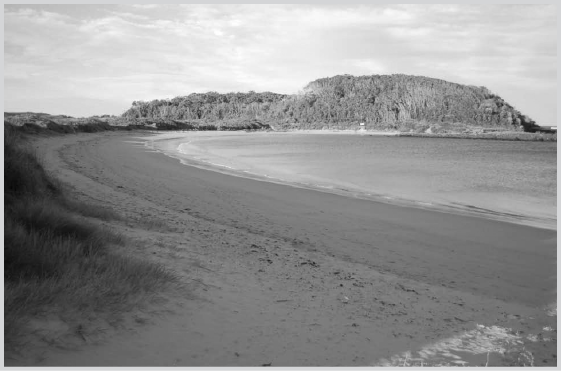
Broulee Island, currently joined to the mainland.
A nother summer has come to the coast, another La Nia summer. For the second year in a row, the weather has been cool and wet, at least compared with the baking hot drought years of the past decade. Once again there are floods in Queensland and parts of northern New South Wales. So far the rising waters have been less widespread and less destructive than last summer, although its only January 2012 and the Bureau of Meteorology is predicting at least another month of rain and warning that more floods may be on their way.
La Nia is distinguished by a large mass of warm surface water gathering in the western Pacific Ocean. This puts more moisture into the atmosphere, helps drive the Asian monsoon, and pushes clouds down across northern Australia. Newspapers report that 2011, while relatively wet and cool, was nevertheless the warmest La Nia year on record. Thats not good news; the warmer the water in the western Pacific, the greater the chance of more frequent and more powerful cyclones heading towards the east coast of Australia. But so far this summer, no cyclones, nothing remotely like the devastation wrought by Cyclone Yasi. Fingers crossed.
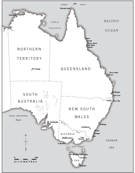
Its almost a year to the day since I set off to explore Australias east coast, ostensibly to catalogue the myriad threats posed by climate change, but also just to see it, in all its unspoilt grandeur and seaside kitsch. As I write Im at Broulee on the New South Wales South Coast, at the holiday house shared by my family, wallowing in the traditional post-Christmas beach holiday. Today I took my kids, Cameron and Elena, down to the small beach formed by the spit that stretches between Broulees headland and the nearby island. For, at this time, the island is no longer an island; its joined to the mainland by a seemingly substantial dune system stabilised by low-lying scrub. The south-facing beach is typically sheltered from the swell by the island and shallow reefs, bestowing it with a type of Mediterranean calm. My daughter, like my mother, loves swimming here, away from the surf and swell. But today there was a strong southerly blowing, inciting white caps and whipping sand into our faces. So we crossed the sandy isthmus, all 15 metres of it, to North Broulee Beach. Its a long beach, kilometres long, but up near the island it curls into a shallow, north-facing bay, completely sheltered from the southerly. It was only when we climbed the dunes that I realised that the tide was out. Back on the windward side, the southerly had pushed the sea well up the beach, but on the leeward side the sea had retreated further out than I had ever seen it. It was, I realised, the day of the summer king tide, when the sea advances further and retreats more dramatically than on any other day of the year.
After swimming and a bit of horseplay, the kids and I walked off towards the northerly side of the island. On this day we could simply walk across the sand where the water had retreated. The tide was so low that for a panicked moment I wondered if we had stumbled across the beginnings of a tsunami. Rounding the point of the island, we came across the most ephemeral of rock pools, the size of several backyard swimming pools, separated from the ocean for a few hours by this infrequent phenomenon. Sea grass lay limp in the shallows and surprisingly large fish zipped this way and that while small zebra-striped fingerlings clouded curiously around our legs as we waded in. A wet slapping alerted us to a stranded ray, marooned by the retreating tide on the still-wet sand near the pool. It was the size of a large dinner plate. Poor Mr Ray, entreated my daughter, looking at me with her puppy-dog eyes. So I climbed up into the bush and found a couple of sticks. Carefully, I dug them into the sand beneath the ray and half carried it, half flung it flapping back into the pool; Elena clapped her hands with approval. Once back in the safety of the water, Mr Ray displayed his gratitude by immediately beaching himself again. This time, at least, he was still partially in the water, and the tide wasnt about to fall any lower. I was explaining this to Elena when movement caught my eye in the seagrass: an octopus insinuating its way through the weeds, perfectly camouflaged save for its liquid creep. The kids gathered round and we watched its slithering progress. Warning them not to get too close, I pointed out the brown rings around its tentacles, explaining that if the octopus was provoked the rings could turn an iridescent blue and its bite could kill. They looked on with suitable awe, eyes wide. I have no idea if it was indeed a blue-ringed octopus, but the rock pools of southern New South Wales are one of its primary habitats: a lesson well dispensed.
Later, after more swimming and ball games, we packed up and headed for the car, back across the spit towards the south-facing beach. I stood for a while atop the dune and, squinting into the sand-laden wind, surveyed the two beaches separated by this narrow isthmus of dune. The water level on the southern beach was at least a metre higher than its northern neighbour. I wondered what sort of pressure was being exerted on the dune. It seemed quite a fragile thing, that dune. And I knew there had been times when it had failed in holding back the Pacific. When I was a teenager, the island was indeed an island, and the strait between it and the shore a treacherous channel of rapidly flowing water. Later, as sand built up, it was possible to walk to the island, but only at low tide. Now the dune feels permanent, sheltering the twin beaches between the island and the headland. Then again, the same impression of permanence had once fooled the early settlers. Walk around the island, close by where the kids and I found our rock pool, and rusted remnants of rail lines protrude from the scrub, the last indication there was a small port here back in the nineteenth century. The settlers made the mistake of creating a track along the top of the dunes to connect the island jetty with the headland. The track helped erode the sand, and in 1873 a wild storm carved its way through the spit, separating the island from the shore. The roar of the sea as it passed through the breach was reportedly heard many kilometres away. Since then, the dune has periodically reformed and dissolved, with six breaches between 1966 and 1988 alone, before a more stable formation asserted itself.
Next page

