POSTCARD HISTORY SERIES
Along Iowas
Historic Highway 20
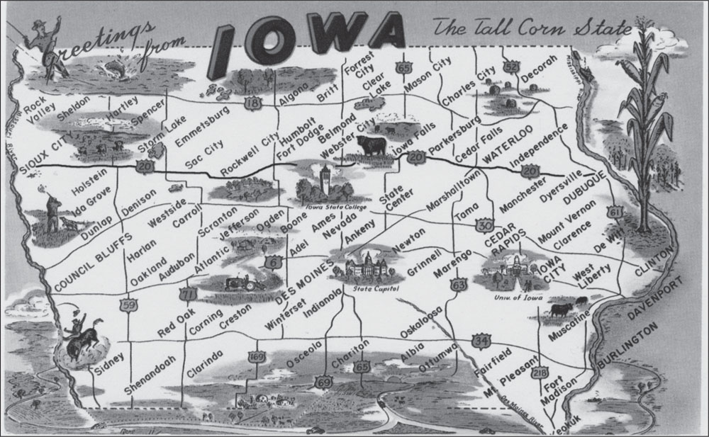
HISTORIC HIGHWAY 20 ACROSS NORTHERN IOWA. Spanning the state from the Mississippi to the Missouri River, historic Highway 20 was northern Iowas principal artery for both commercial and leisure travel from 1926 until the arrival of the Interstate Highway System. (Authors collection.)
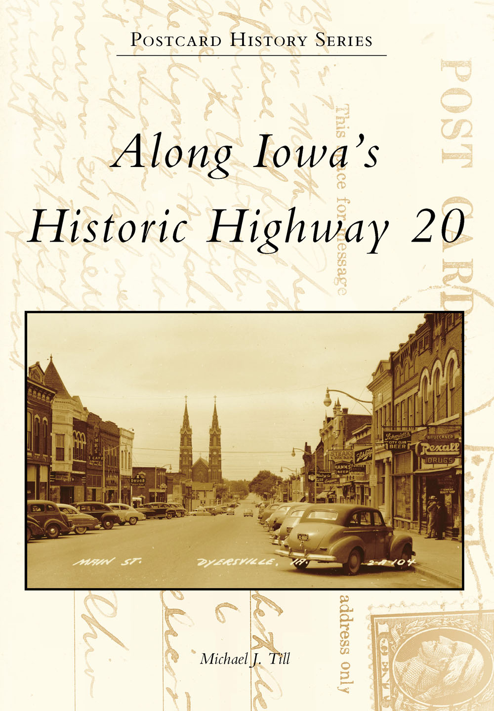
ON THE FRONT COVER: A TYPICAL IOWA MAIN STREET. The original Highway 20 typically went from main street to main street as it passed through cities and towns along its route. Here, the road is heading west through Dyersville on its journey across Iowa. St. Francis Basilica, one of the states most historic buildings, is in the distance. (Authors collection.)
ON THE BACK COVER: A WELCOMED STOP FOR HIGHWAY 20 TRAVELERS. Travelers along the countrys early highways encountered a variety of accommodations ranging from rooms in private homes to small frame cabins, converted farm buildings, and even faux tepees. This small motel utilized Quonset buildings reminiscent of World War II barracks. (Authors collection)
POSTCARD HISTORY SERIES
Along Iowas
Historic Highway 20
Michael J. Till

Copyright 2014 by Michael J. Till
ISBN 978-1-4671-1290-1
Ebook ISBN 9781439648414
Published by Arcadia Publishing
Charleston, South Carolina
Library of Congress Control Number: 2014938260
For all general information contact Arcadia Publishing at:
Telephone 843-853-2070
Fax 843-853-0044
E-mail
For customer service and orders:
Toll-Free 1-888-313-2665
Visit us on the Internet at www.arcadiapublishing.com
To all who remember the crowding and heat in the backseat of the family sedan before the days of air-conditioning, iPods, and smartphones
CONTENTS
ACKNOWLEDGMENTS
Thanks are due to the long-ago civic leaders and business owners who had the foresight to recognize the value of picture postcards in promoting their communities. These visual and historic records provide invaluable insights into the way it was in the days when two-lane highways and mom-and-pop tourist courts reigned supreme. Thanks also to the vendors of vintage postcards without whose help this book would have been more difficult if not impossible. Many searched for Highway 20 cards for me, which was greatly appreciated. The same is true for persons responsible for modern web pages describing towns and historic sites on Highway 20. I have borrowed freely from their descriptions and wish to acknowledge their contributions.
Librarians and staffs of county historical societies and museums along Highway 20 were helpful in directing me to interesting information about the road. Many shared personal memories of the postcard sites, and if someone did not know the answer to a question, their telephone call to a longtime resident of the community usually produced the information. Thus, many grandparents, uncles, aunts, and community elders contributed indirectly to this book.
Last but certainly not least, I wish to thank my wife, Christine, for her help. A librarian herself, she knew sources of information and how to access them. She also was an excellent collaborator as we drove historic Highway 20 researching specific sites. Many of her observations have been incorporated into the captions in the book.
All images in this book come from the authors personal collection.
INTRODUCTION
Highway 20 across the United States is a result of the Federal Aid Highway Act of 1921. This landmark legislation was enacted to answer the demand for better roads, as motorized travel gained in popularity during the early 20th century. The act provided funding for development and maintenance of seven percent of each states road system, provided the roads were interstate in character, meaning that the designated roads in one state must connect with similarly designated roads in the adjacent states. Thus, the original federal highways were not new roads but rather existing roads that when joined together formed a continuous nationwide transportation network. The roads to be included were identified by 1923, and in 1926, the first Interstate Highway System came into existence. The numbering system was adopted, which is still in use today. Major east-west routes were assigned a number ending in 0, and the numbering sequence was from north to south. To avoid the unique number 0, the northernmost road was given the designation 2, and the remaining roads were designated 10, 20, 30, and so on to 90. Highway 2 extended from Maine through New York, but then it was separated by the Great Lakes before beginning its western section from Michigan to the Pacific Ocean. Highway 10 extended only from the Midwest to the West Coast. From 1926 to 1940, Highway 20 extended from Boston to the east entrance of Yellowstone National Park. In 1940, the western section was completed to Newport, Oregon, making Highway 20 the northernmost of the true cross-country highways, and at 3,365 miles, the longest. Although not as famous as its cousins Highway 30 (much of which coincided with the original Lincoln Highway) or Route 66 (which is not cross-country), Highway 20 nonetheless served with equal importance in introducing automobile and truck traffic to America.
The countrys original federal highway system owes much to the brilliance of Iowan Thomas McDonald, chief of Iowas Bureau of Roads. He was far ahead of his time in recognizing the need to organize the roadways of the day into cohesive units. While still a young engineer, McDonald analyzed Iowas roads to determine which were the most used, which had the most potential for economic benefit, and which types of road surfaces were best for the prevailing conditions. McDonalds talents were quickly recognized, and he was offered the position of Federal Highway director but at a salary less than what he was being paid in Iowa! After some negotiation, he accepted the position, where he became a pivotal figure in furthering the early interstate highways described above.
Thanks to McDonalds expertise, Iowas highway system was further developed than most other states when Federal Highway Aid became available in 1926. The route from Dubuque to Sioux City was well established, although much of the road surface was still gravel. Citizens along the route realized the roads importance, and they worked hard to promote it. Named highways were popular at the time, and by 1910, two names had been suggested. The first, River-to-River Highway, emphasized the termini at the Mississippi and Missouri Rivers. Hawkeye Highway proved to be more popular, and that name is still heard occasionally today. The majority of the Hawkeye Highway was selected for inclusion in the first federal highway system, and the designation Highway 20 has served well for almost a century.
The advent of the Interstate Highway System in the 1950s was a boon for motorized travel, but it had a downside. Frequently, the course for the new superhighways was directly over the former local roads. The latter were simply bulldozed away, thus completely obliterating their existence together with the memories they evoked. Fortunately, Highway 20 escaped this fate. The original road has survived almost entirely intact, and to this day, it remains a pristine country highway, epitomizing the charm and beauty of rural Iowa. Modern Highway 20 and Iowas Interstate 80 parallel original Highway 20 rather than being superimposed directly on top. Most roads and streets that carried the original Highway 20 still exist. Local numerical or street names have been assigned, but with a bit of effort, one can still follow historic Highway 20 across Iowa much as our ancestors did decades ago.
Next page

