IMAGES
of America
THE BUILDING OF THE
OROVILLE DAM

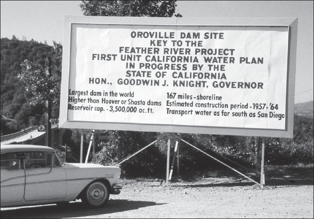
This photograph from 1957 shows the very first billboard to be erected at the Oroville Dam site. It was put up shortly after Gov. Goodwin Knight designated the area as the site of the pending Oroville Dam. The information on the billboard was modified when Gov. Edmund G. Brown took office in 1959. Construction of the dam was completed in 1968. (Courtesy of Butte County Historical Society.)
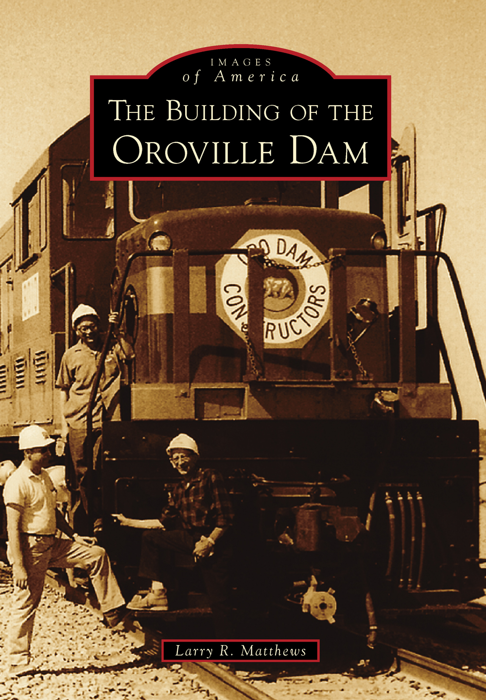
ON THE COVER: Engine No. 8010 is seen in good times in late 1963. It is at the borrow area, taking on material. An unlucky engine, it was involved in a fatal accident at the borrow on April 9, 1964, when it collided with a Cat 660 scraper. It also was totally destroyed in a head-on collision on October 7, 1965, in which four crewmen were killed. (Courtesy of Butte County Historical Society.)
IMAGES
of America
THE BUILDING OF THE
OROVILLE DAM
Larry R. Matthews

Copyright 2014 by Larry R. Matthews
ISBN 978-1-4671-3079-0
Ebook ISBN 9781439644546
Published by Arcadia Publishing
Charleston, South Carolina
Library of Congress Control Number: 2013938692
For all general information, please contact Arcadia Publishing:
Telephone 843-853-2070
Fax 843-853-0044
E-mail
For customer service and orders:
Toll-Free 1-888-313-2665
Visit us on the Internet at www.arcadiapublishing.com
This book is dedicated to the 34 construction workers who died working on the various projects related to the Oroville Dam.
CONTENTS
ACKNOWLEDGMENTS
The various agencies and individuals listed here provided assistance and authorized the use of their photographs for this project. My thanks go out to Nancy Brower, Lucy Sperlin, Sally McCoy, and Bill Burg of the Butte County Historical Society (BCHS). Thanks also to Michael J. Miller and Paul Hames of the Graphic Services Branch of the California Department of Water Resources (CDWR). Charlie and Judy Jensen (CJ) of Oroville contributed photographs that Charlie took in the first few days after the train tunnel disaster. Gene Merian (GM) of Oroville; Michael Hogan (MH) of Oroville; Janet Dawson (JD) of Paradise; Jerry Topper of Roseville; Gene Topper (GT) of Tucson, Arizona; and Jim McDonnell and the South Oroville African American Historical Society (SOAAHS) contributed multiple photographs from their collections. Contributing single photographs were Marvin McTigue of Fullerton, Albert M. King Sr. and Jr., and Garrett Jackson, all of Oroville. Tony Ciaffoni of Brisbane, Australia, provided a successful lead regarding a very unique Bidwell Bar photograph. Image sources in this book are identified either by name or by the abbreviations included here.
My thanks go to Jerry Topper for the information about his father, Gene Topper, and their dog Moose. I am grateful to Gene for sharing his unique and charming story and photographs.
Special thanks to Scott Roberts of Yuba City, who provided me with technical assistance and some photographs and who accompanied me in finding long-lost Oroville Damrelated historical locations.
I would also like to thank my wife, Sharon; my family; and all of those friends in Butte, Sutter, and Yuba Counties who were so supportive of this project. We all reside downriver from the Oroville Dam and know how truly valuable it is to our area.
I want to thank the memory and talent of the late Butte County historical writer Bill Talbitzer. Bills many books about Oroville-area history first fascinated me in 1963 and have continued to inspire my writing.
Researching for this project could have been tedious. Instead, those mentioned above helped make it a joy. They will always have my thanks.
INTRODUCTION
The small mining town of Ophir was established in October 1850 in Californias northern Sacramento Valley. It was founded along the Feather River where it flows out of the Sierra Nevada Mountains and turns south.
Millions of dollars in gold and some diamonds were found in the area. Some miners struck it rich, but many went broke. By 1856, the town was renamed Oroville (based upon the Spanish word for gold and the French word for town).
At one time, Oroville was the largest mining town and the fifth-largest town in California. In addition to the mining industry, Oroville was essentially an agricultural community, and very successful nut and fruit industries continue to flourish there even today.
In 1906, the city of Oroville was incorporated. It had previously become the county seat of Butte County in 1856 after the cities of Hamilton and Bidwell Bar had held the honor for a short time.
From 1898 to 1918, enormous gold dredges plied the Feather River area. It is estimated that $30 million in gold was recovered in the Oroville area. The use of dredges left acres and acres of ponds and enormous piles of rock. Those rock piles would play an integral part in what was to come later. By 1950, the state of California was concerned about water. Sometimes, there was too much, but mostly there was too little, especially in Southern California.
There had been major floods on the Feather River in 1906, 1907, 1909, 1928, 1937, and 1955. These disasters had greatly affected Oroville and the MarysvilleYuba City area that is located 30 miles south.
In 1957, preliminary work had started on the plan to build the Oroville Dam, a major part of the California State Water Project. The dam location would be nine miles to the northeast of Oroville, near the confluence of the North, Middle, and South Forks of the Feather River. At 770 feet, it would be the highest earth-filled dam in the world44 feet higher than Hoover Dam. It was estimated that the dam would impound more than three and a half million acre-feet of water and that the lake would have a shoreline of 167 miles. Much of the dam would be constructed with many of those supposedly useless rocks left over from the old gold-dredging operations.
But there was much more to the project than just the big dam, and this book will attempt to document that fact. For miles around, the area would be transformed. There were canals, bridges, roads, dams, tunnels, and railroads to be built or rerouted. All of the trees had to be removed from the proposed lake area. Two enormous powerhouses needed to be built: one beneath the dam and the other at the Thermalito Power House. A forebay and afterbay also needed constructed.
There was history to be saved or destroyed. In the lake area, 350 pioneer graves needed to be excavated and relocated. The town of Bidwell Bar had to be burned down, the old Enterprise Bridge needed to be demolished, and Hansells Bridge had to be blown up. The historic 1856 Bidwell Bar Bridge, tollhouse, and Mother Orange Tree all had to be removed and relocated.
Some history would be lost. Holes would be gouged out of McLaughlins Wall, and it would be inundated by the waters behind the Thermalito Diversion Dam.
There was also a whole new railroad to build. The Oro Dam Constructors Railroad moved all of the rock materials, and the length of the route was 12 miles. It started at the borrow area, located on the west side of the Feather River southwest of Oroville. It then crossed to the east side of the river, traveled north, and crossed to the north side of the river. From there, it went east, traveling under the Highway 70 freeway bridge and recrossing the river between the Upper Thermalito Bridge and the new fish hatchery dam. Traveling along the east side of the river, it ran north and east, through an old railroad tunnel, and then on to the construction site of the dam. This material-handling system was one of the very first to be designed by computer.
Next page


