Table of Contents
List of Illustrations
- Chapter 1
- Chapter 2
- Chapter 3
- Chapter 4
- Chapter 5
- Chapter 7
- Chapter 8
- Chapter 9
- Chapter 10
- Chapter 11
- Chapter 12
- Chapter 13
- Chapter 14
- Chapter 15
- Chapter 16
- Chapter 17
- Chapter 18
- Chapter 19
Landmarks
List of Pages

In the top panel, a painting shows a large group of British Gunners (warriors) manning cannons and firing on American navy sailing warships in the distance. Close to shore is a British naval warship, the HMS Royal George which is anchored and also firing on the American warships. The centre panel has the author's name and titles of the book. The bottom panel has a painting of a very large ship (warship) beginning to slide down a slipway into the water. The ship has five flags, and is surrounded by small groups of people.
Warriors and Warships
Warriors and Warships
Conflict on the Great Lakes and the Legacy of Point Frederick
ROBERT D. BANKS

Copyright Robert D. Banks, 2023
All rights reserved. No part of this publication may be reproduced, stored in a retrieval system, or transmitted in any form or by any means, electronic, mechanical, photocopying, recording, or otherwise (except for brief passages for purpose of review) without the prior permission of Dundurn Press. Permission to photocopy should be requested from Access Copyright.
Publisher: Kwame Scott Fraser | Acquiring editor: Graham Matthews | Editor: Michael Carroll Cover and interior designer: Laura Boyle
Library and Archives Canada Cataloguing in Publication
Title: Warriors and warships: conflict on the Great Lakes and the legacy of Point Frederick / Robert D. Banks.
Names: Banks, Robert D., author.
Description: Includes bibliographical references and index.
Identifiers: Canadiana (print) 20220403775 | Canadiana (ebook) 20220406901 | ISBN 9781459750777 (hardcover) | ISBN 9781459750661 (PDF) | ISBN 9781459750678 (EPUB)
Subjects: LCSH: Navy-yards and naval stationsOntarioFrontenacHistory19th century. | LCSH: Shipbuilding industryOntarioFrontenacEmployeesHistory19th century. | LCSH: ShipbuildingOntarioFrontenacHistory19th century. | LCSH: Frontenac (Ont.)History 19th century. | CSH: OntarioHistory1791-1841. | CSH: OntarioHistory1841-1867. Classification: LCC VA401.O6 B36 2023 | DDC 359.7/097137109034dc23

We acknowledge the support of the Canada Council for the Arts and the Ontario Arts Council for our publishing program. We also acknowledge the financial support of the Government of Ontario, through the Ontario Book Publishing Tax Credit and Ontario Creates, and the Government of Canada.
We acknowledge the support of the Kingston & Area Association of Museums, Art Galleries and Historic Sites, and the City of Kingston. We also acknowledge the support of the Frontenac Heritage Foundation.
We acknowledge that Point Frederick and Kingston are on the traditional homeland of the Anishinaabe, Haudenosaunee, and the Huron-Wendat, and thank these nations for their care and stewardship over this shared land.
Care has been taken to trace the ownership of copyright material used in this book. The author and the publisher welcome any information enabling them to rectify any references or credits in subsequent editions.
The publisher is not responsible for websites or their content unless they are owned by the publisher.
Printed and bound in Canada.
Dundurn Press
1382 Queen Street East
Toronto, Ontario, Canada M4L 1C9
To Patti
Contents
No other harbour was tenable as a naval station; with its fall and the destruction of shipping and forts, would go the control of the lake, even if the place itself were not permanently held. Deprived thus of the water communications, the enemy (i.e., British) could retain no position to the westward, because neither reinforcements nor supplies could reach them.
Rear-Admiral A.T. Mahan, U.S. Navy, in J.M. Hitsman, Kingston and the War of 1812, Historic Kingston 15 (January 1967)
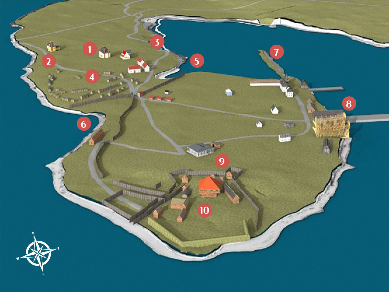
P oint F rederick in 1815.
- Royal Navy hospital
- Front road
- Back road
- Shanties
- Navy Bay Inlet
- Kingston Inlet
- Navy Bay sandspit
- Mould loft, HMS Wolfe, and HMS Canada
- Commodores quarters
- Point Frederick battery
Description
A colour schematic of the Point Frederick peninsula from an aerial viewpoint looking north. The water is blue, the ground is green and beach areas along the shore are light gray. Numbers from one to ten are arranged on the image for reference to 1815 features that are described in the narrative. The south tip of Point Frederick is at the bottom-centre. The north portion is at the top-left. Navy Bay borders the peninsula on the right, while Kingston Harbour is on the left. No.1, the hospital is near the top and centred on the peninsula. No. 2 and 3 are the front and back roads respectively and roughly follow the shorelines from the north to the dockyard gate. No. 4 are the shanties, many small log houses on the hill north of the gate. Beside the gate on both sides, and pinching the peninsula into a narrowed isthmus are no. 5 Navy Bay Inlet and no. 6 Kingston Inlet. South of the gate, the peninsula widens and forms a large dockyard area. The work area of the dockyard is on the shore of Navy Bay. From the north portion of the dockyard shoreline no. 7, a narrow sandspit, reaches north into Navy Bay and forms a lagoon with land on three sides. South of the sandspit, and on the east shore is no. 8, which identifies the mould loft and two partly built vessels still on land, the HMS Wolfe and HMS Canada. No. 9 is the commodores quarters, a painted log house which is in the center of the south portion of the peninsula. No. 10 is a fort surrounded by earthworks which is named Fort Frederick.
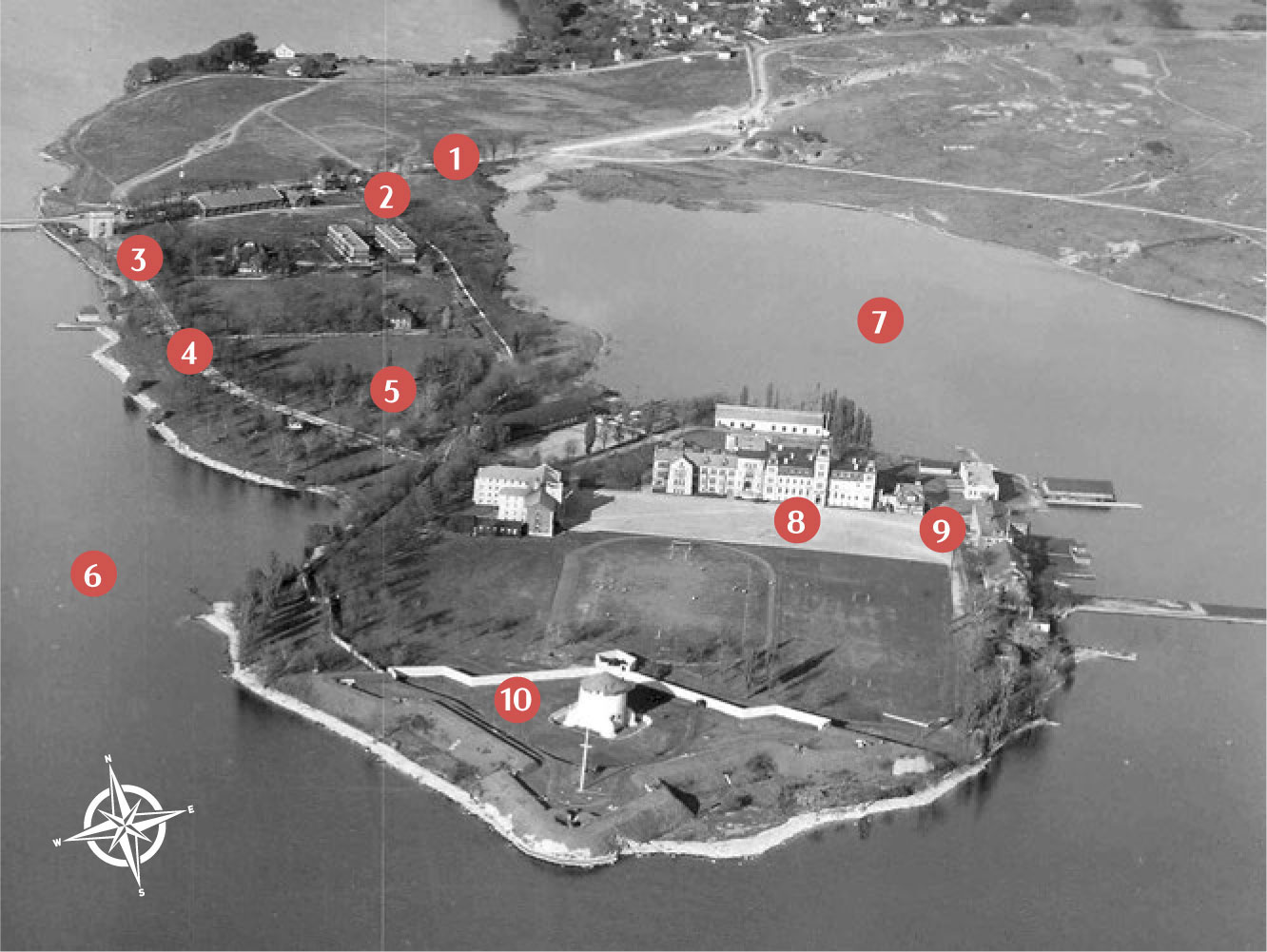
P oint F rederick in 1933.
- Front Road (Highway 2)
- Vrit Avenue
- Site of Admiralty House
- Valour Drive
- The hill
- Kingston Harbour
- Navy Bay
- Mackenzie Building
- Stone Frigate
- Fort Frederick
Description
This black and white aerial 1933 photo of the Point Frederick peninsula is from the same vantage point as S #3. Numbers from one to ten are similarly arranged on the image for reference to 1933 features that are described in the narrative. No.1 is the Front Road, or Highway 2 that crosses Point Frederick (there are two front roads, this one and the other (No. 4) that parallels the west shore of Point Frederick). No. 2 Vrit Avenue is a rebuilt and straightened back road. No. 3, near the top-left of the photo on the west shore, is the site of the Admiralty House. No. 4 Valour Drive is a rebuilt and straightened front road. No. 5 shows the hill north of the gate, now without shanties. No. 6 identifies Kingston Harbour. No. 7 identifies Navy Bay on the right. No. 8 is Mackenzie Building, the first educational building located north of the RMC parade square. No. 9 is the Stone Frigate, on the east shoreline and east end of the RMC parade square. No. 10 is the 1847 version of Fort Frederick.



 In the top panel, a painting shows a large group of British Gunners (warriors) manning cannons and firing on American navy sailing warships in the distance. Close to shore is a British naval warship, the HMS Royal George which is anchored and also firing on the American warships. The centre panel has the author's name and titles of the book. The bottom panel has a painting of a very large ship (warship) beginning to slide down a slipway into the water. The ship has five flags, and is surrounded by small groups of people.


