Contents
Best Easy Day Hikes Series
Best Easy Day Hikes
Bend and Central Oregon
Third Edition
Lizann Dunegan


An imprint of Globe Pequot
Falcon and FalconGuides are registered trademarks and Make Adventure Your Story is a trademark of Rowman & Littlefield.
Distributed by NATIONAL BOOK NETWORK
Copyright 2018 by Rowman & Littlefield
Maps: Rowman & Littlefield
All rights reserved. No part of this book may be reproduced in any form or by any electronic or mechanical means, including information storage and retrieval systems, without written permission from the publisher, except by a reviewer who may quote passages in a review.
British Library Cataloguing in Publication Information available
Library of Congress Cataloging-in-Publication Data available
ISBN 978-1-4930-3032-3 (paperback)
ISBN 978-1-4930-3033-0 (e-book)
 The paper used in this publication meets the minimum requirements of American National Standard for Information SciencesPermanence of Paper for Printed Library Materials, ANSI/NISO Z39.48-1992.
Printed in the United States of America
The authors and Rowman & Littlefield assume no liability for accidents happening to, or injuries sustained by, readers who engage in the activities described in this book.
Contents

Acknowledgments
This hiking guide has always been one of my favorites to update. I want to thank all of my hiking partners and my two canine companions Bear and Tiz for always wanting to go exploring with me. Also thanks to the Falcon editing team.
Introduction
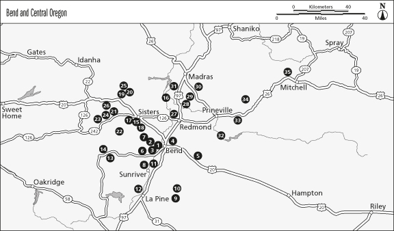
This small pocket guide contains thirty-five easy day hikes that allow you to explore Bend and surrounding natural areas in Central Oregon. A high-desert ecosystem of sagebrush, juniper, and ponderosa pine characterizes the dry central part of this state, where volcanic activity and erosion have formed amazing gorges and unique rock formations.
Coursing through all of this is the mighty Deschutes River, beginning high in the Cascade Mountains and traveling north to south through the heart of Bend, Central Oregons largest city.
Many consider Bend the gateway to the High Cascade Lakes Region and Deschutes National Forest. It serves as the geographic and popular center to this area of the state. Many hikes off the Cascade Lakes Highway promise wonderful mountain and lake views, such as the Green Lakes Trail, and the Ray Atkeson Memorial Trail. If youre looking for trails in town, check out the Pilot Butte State Park, Shevlin Park, First Street Rapids ParkDeschutes River Trail, South Deschutes River Loop, and the Old Mill DistrictDeschutes River Loop.
Afterward, consider visiting the Newberry National Volcanic Monument, which can be easily accessed from the city of Bend (its southeast of Bend off US 97). Home to Newberry Caldera, a 500-square-mile crater that houses Paulina and East Lakes, this national monument has a rich geologic history, evident in its hot springs, lava flows, and cinder cones. The 0.7-mile Big Obsidian Flow Trail takes you on a fascinating tour of Oregons youngest lava flow. To see the national monument from a different perspective, try the Paulina Lake Loop, which circles scenic Paulina Lake.
Located northwest of Bend, the small Western town of Sisters is a major access point to both the Mount Washington and Mount Jefferson Wilderness Areasserious volcano country. Trails not to be missed here are Matthieu Lakes, Hand Lake, and Little Belknap Crater. The Matthieu Lakes Loop Trail takes you past two scenic high alpine lakes and offers nice views of the Central Cascade Mountains. Hand Lake Trail takes you along the shores of scenic Hand Lake and offers stunning views of Mount Washington. Little Belknap Crater Trail takes you across the moonlike landscape of an ancient lava flow. From the summit of the crater you can enjoy sweeping views of the snow-topped Three Sisters Mountains, Mount Washington, and the surrounding lava flows and craters that make up the Mount Washington Wilderness. For a pristine river hike, take a tour on the West Metolius River Trail and admire the lush, spring-fed river ecosystem. If you enjoy waterfalls, check out the Chush Falls hike. If you dont have much time and you are looking trails that are close to town check out the Eagle Rock Loop Trail and the Whychus Creek Trail.
Located 5 miles northeast of Redmond, Smith Rock State Park is also located in the center of this open, high- desert country. It features spectacular pinnacles, columns, and cathedral-like cliffs that rise more than 400 feet above a mammoth gorge carved by the Crooked River. If you are looking for solitude, explore the Gray Butte and Rimrock Springs Natural Area hikes. Both are located within a 30-minute drive of Redmond in the Crooked River National Grasslands and feature high-desert scenery. If you are a fan of hiking along rivers, check out Alder Springs. Located in the Crooked River National Grassland, this hike starts out on a high sagebrush plateau and then drops down into a river canyon. The route follows spring-fed Whychus Creek to where it joins the Deschutes River.
Around Prineville, try the Chimney Rock hike, which promises solitude and nice views of the Crooked River Canyon and distant Central Cascade peaks. A less frequently visited but no less stunning area is the Mill Creek Wilderness, located about 20 miles northeast of Prineville off US 26. Twin Pillars Trail takes you through this wilderness, characterized by open, parklike stands of ponderosa pine, grand fir, and Douglas fir forests. Another destination not to be missed is the Painted Hills Unit of the John Day Fossil Beds National Monument. Several short hikes in this area feature close-up looks at the areas fossil beds and beautifully colored hills.
If you are traveling through Madras stop check out the Tam-a-lau Loop Trail that takes you on a tour to the top of a high peninsula above Lake Billy Chinook in Cove Palisades State Park.
Weather
Unlike the Willamette Valley to the west, the central part of the state is much sunnier and dryer. The average annual rainfall in this part of the state is 12 inches, and blue skies are the norm. Summer temperatures range from the mid-70s to low 90s; winter temperatures can range from the mid-20s to mid-50s. Be prepared for a substantial amount of snow in the high mountain areas above 4,000 feet and periodic snow showers at lower elevations. Hikes at elevations above 4,000 feet may not be accessible until late June into early July.
Preparing for Your Hike
Planning your hiking adventure begins with letting a friend or relative know your trip itinerary so that they can call for help if you dont return at your scheduled time. Your next task is to make sure you are outfitted to experience the risks and rewards of the trail. This section highlights clothing and gear that can help you get the most out of your day hike.
Clothing
Clothing is your armor against Mother Natures little surprises. Clothing that can be worn in layers is a good strategy for dealing with the often unpredictable Central Oregon weather. In spring, fall, and winter, the first layer youll want to wear is a wicking layer of long underwear that keeps perspiration away from your skin. Long underwear made from synthetic fibers is an excellent choice. These fabrics wick moisture away from the skin and draw it to the next layer of clothing, where it then evaporates. Avoid long underwear made of cotton; it is slow to dry and keeps moisture next to your skin.


 The paper used in this publication meets the minimum requirements of American National Standard for Information SciencesPermanence of Paper for Printed Library Materials, ANSI/NISO Z39.48-1992.