Acknowledgments
Our gratitude goes out to Tim Palmer for inspiration and a legacy of river storytelling; Todd and Jaco at Wet Planet Whitewater Center for warm places to land and a steady river family; Zach with Northwest Rafting Company; the Canyons Inc. family; Dick and Wilma Shedd; Duncan Storlie and Diane Tessari; Kerr Duson; the American Packrafting Association; and American River Touring Association (ARTA). Our deepest gratitude goes to all of our family for their support, encouragement, and babysitting.
Special thanks to the incredible staff at American Whitewater: Thomas OKeefe for fact-checking and accompanying us on the water; Kevin Colburn for the Montana connections and explorations; and Mark Singleton for his leadership of this power-house river conservation nonprofit.
Thanks to our contributors:
Tim Palmer, Moe Witchard, Thomas OKeefe, Kevin Colburn, Nate Wilson, Matt Curry, Lori Turbes, Anna Wagner, Sam Swanson, Michelle Francesco, Rob Elliott, Northwest Rafting Company, Dave Fusilli, Dave Hoffman, Michael Hughes, Zach Collier, Danielle Keil, Krissy Kasserman, Kathy Lampman, Brendan Wells, Dave Gardner, Leland Davis, Curtis England, Western Rivers Conservancy, Meredyth Babcock, Jim Sullivan, Priscilla Macy, Jacob Cruser, Leif Embertson, Will Taggert, Aaron Pruzan, Kylee Allen, Katie Abercrombie, and Andrea Cracchiolo.
OREGON
ROGUE RIVER
RIVER DESCRIPTION
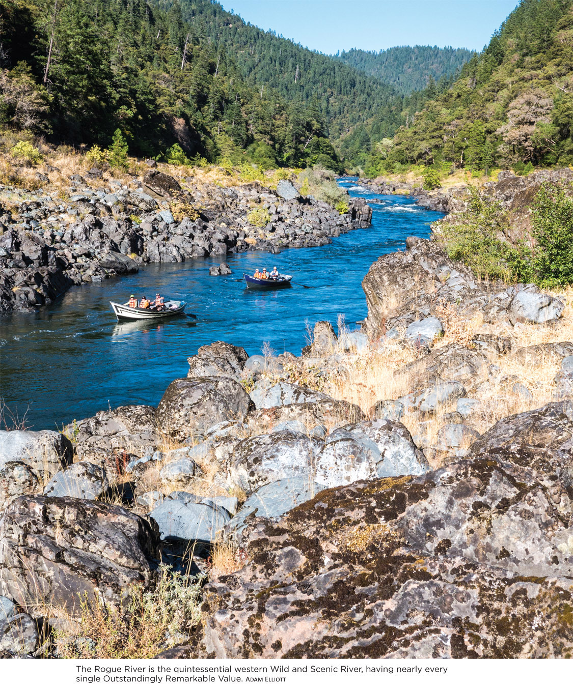
Descending from Crater Lake National Park, in the high Cascade Mountains of southwestern Oregon, to the Pacific Ocean, the Rogue River has long captivated American explorers. Native Americans flocked to the rivers cold and powerful waters for the abundance of salmon and to the fertile lands alongside. Gold miners discovered riches along the rivers banks. Today, every river runner yearns to add the legendary Rogue to his or her list of familiar watersheds.
Craggy but smooth rocks jut from the water that manipulate currents and create rapids that entice both intermediate river runners looking to paddle their own boats and novice adventurers joining a commercial trip. Along the banks of the river, the geologic foundation is covered by a rich and complex Siskiyou forest ecosystem with cascading mountain streams and rugged terrain. The Rogues rich wildlife and remarkable beauty combine with a storied history of Native Americans and early settlers to make the Rogue many paddlers favorite yearly river trip. Its no surprise that the Rogue joined the original eight rivers signed into the Wild & Scenic Rivers Act in 1968.
Takelma Native Americans lived in the upper Rogue River area until floods of settlers entered the valley in search of gold in the 1850s. Encounters between the groups were not pleasant, and soon the Natives were forced onto reservations far away. Evidence of all former residents can be found along the Rogue and within the valley.
Commercial outfitters have really upped their game on this classic river stretch: Specialty food and wine trips provide a gourmet camping experience; brewer-hosted trips provide guests with an opportunity to sample an impressive array of local craft beers; and classic lodge-to-lodge trips allow river runners to experience a river-accessible lodge each night. Check out Northwest Rafting Company (nwrafting.com) for some of these options.
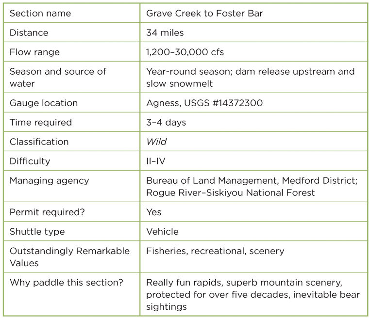
We must apologize to the Rogue River for shortening this description to only the section between Grave Creek and Foster Bar. Recreational and Scenic designations extend both upstream and downstream of this Wild total length, which is simply the most iconic. Many groups begin their trips at or upstream of Galice, a small outpost and shuttle hub. This upper section also provides a day or two of class II warm-up before descending below Grave Creek. Other trips continue downstream past Foster Bar. Youll just have to plan multiple trips to this watershed to see it all.
PADDLERS NOTES
Between May 15 and October 15 all river runners need a lottery-issued permit to float this section of the Rogue. All other times of year there is a self-issued permit system. Apply for a lottery system permit in December and January of each year at Recreation.gov. If you dont win the lottery, you can also call the BLM Smullin Visitor Center at Rand (541-479-3735) to try to pick up cancellations for the near future or show up at Rand (just upstream from Grave Creek) first thing the morning of your desired launch and pick up same-day cancellation spots. Commercial outfitters will release their user days to the public a few days prior to launch if they have not sold them by then.
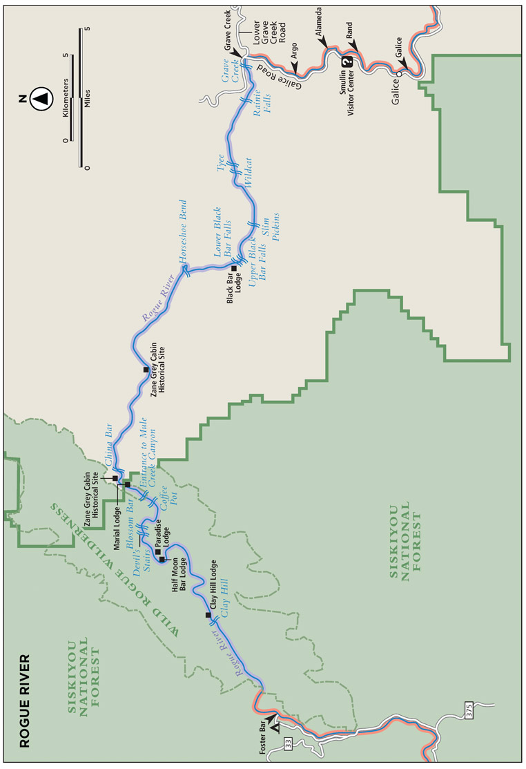
Numerous class II rapids fill the gaps in between the class IIIIV rapids described here. The first of these comes within earshot of the put-in. Grave Creek Riffle and Falls, a typical Rogue whitewater specimen, will get you wet immediately.
A calmer float carries you to the pool above Rainie Falls. Old Man Rainie, an early settler, lived in a small cabin at the base of the falls in the early 1900s. Take your time on the scout from river left. Often salmon can be seen jumping up the falls. The left channel will lead you over the actual falls, a class IV drop at most water levels and class V at high water. Most boaters opt to take the far-right line through the fish ladder. This involves a tricky dance of shipping your oars, lining through tight spots, and even using a bow paddler to prevent broaching. Some boats take the middle chute, just as narrow and technical as the fish ladder but with a steeper drop at the end. Above 3,000 cubic feet per second (cfs), guard rocks in the entrance to the middle chute could send you left over Rainie Falls.
The next class III, Tyee, at river mile 4.8, channels boaters to the right, where some zigzagging moves help avoid a pour-over or hole feature. Slim Pickins, at river mile 6.8, received its name from the early days of blasting the riverbed to open up the channel. A double-punch comes just 2 miles downstream at Upper and Lower Black-bar Falls rapids. A long class II straightaway leads to Horseshoe Bend rapid aroundyesa tight bend in the river at river mile 10.5.
Enjoy a peaceful stretch before whitewater returns at the China Bar rapid at river mile 21.5, just upstream of Rogue River Ranch. The ranchs historical museum is worth a peak and the big green lawn out front deserves an Ultimate Frisbee match.
Suddenly, just 1 mile downstream, rock walls pinch from both shorelines and force the entire rivers powerful flow into the narrow slot between them. This is Mule Creek Canyon, a class IV reach. This one is hard to scout, but its possible from the Rogue River trail. Geologic shifting has occurred in your favor here, with little gradient change within these walls. However, the boils and speed of the water absolutely keep smaller boats on their toes. The Coffee Pot churns about a quarter mile from the head of the canyon; its a seething whirlpool boil that can flip a fully loaded raft at certain flows. Set safety just below here to throw a rope to any swimmers who may enter the Pot. Eddy out on the left toward the end of the canyon to enjoy Stair Creek Falls.
Blossom Bar, a class IV rapid, sits just around the bend. Pull over on the right to walk downstream to scout and watch other paddlers lines. Rafts take the left channel with a quick ferry move back to the center to avoid a jumble of pinning rocks called the Picket Fence that extends from the left bank. There is a good chance youll even see a deflated and pinned raft on the fence during busy summer monthsnot a fun way to end your trip.


