Allen Riedel - Best Easy Day Hikes San Diego
Here you can read online Allen Riedel - Best Easy Day Hikes San Diego full text of the book (entire story) in english for free. Download pdf and epub, get meaning, cover and reviews about this ebook. year: 2020, publisher: Falcon Guides, genre: Home and family. Description of the work, (preface) as well as reviews are available. Best literature library LitArk.com created for fans of good reading and offers a wide selection of genres:
Romance novel
Science fiction
Adventure
Detective
Science
History
Home and family
Prose
Art
Politics
Computer
Non-fiction
Religion
Business
Children
Humor
Choose a favorite category and find really read worthwhile books. Enjoy immersion in the world of imagination, feel the emotions of the characters or learn something new for yourself, make an fascinating discovery.

- Book:Best Easy Day Hikes San Diego
- Author:
- Publisher:Falcon Guides
- Genre:
- Year:2020
- Rating:3 / 5
- Favourites:Add to favourites
- Your mark:
Best Easy Day Hikes San Diego: summary, description and annotation
We offer to read an annotation, description, summary or preface (depends on what the author of the book "Best Easy Day Hikes San Diego" wrote himself). If you haven't found the necessary information about the book — write in the comments, we will try to find it.
Allen Riedel: author's other books
Who wrote Best Easy Day Hikes San Diego? Find out the surname, the name of the author of the book and a list of all author's works by series.


Best Easy Day Hikes San Diego — read online for free the complete book (whole text) full work
Below is the text of the book, divided by pages. System saving the place of the last page read, allows you to conveniently read the book "Best Easy Day Hikes San Diego" online for free, without having to search again every time where you left off. Put a bookmark, and you can go to the page where you finished reading at any time.
Font size:
Interval:
Bookmark:
Allen Riedel is a photographer, journalist, author, and teacher. He lives with his wife, Monique, and children, Michael, Sierra, and Makaila. He writes an outdoor column for the Press Enterprise and has authored several hiking guides, including 100 Classic Hikes in Southern California, Best Hikes with Dogs in Southern California, Best Easy Day Hikes Riverside, and Best Easy Day Hikes San Bernardino. He lives in Riverside, California.
T he Pacific Ocean sits like a glimmering jewel to the west of San Diego. These hikes explore its immediate shoreline and the nearby habitats surrounding the beach.
As you make your way along the trail on the five hikes that follow, youll travel through lagoons, and down towering coastal sandstone bluffs, and youll discover what life was like in San Diego County more than one hundred years ago. Along the way youll feast on a variety of spectacular vistas of the city, the mountains to the east, and the world-famous Pacific blue.
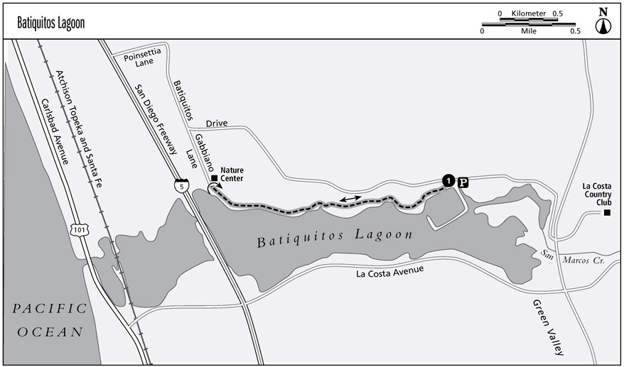
Take a lovely stroll along an ocean-side wetland interpretative trail with fantastic opportunities for bird-watching.
Distance: 2.8 miles out and back
Approximate hiking time: 1.5 hours
Elevation gain: 40 feet
Trail surface: Packed dirt
Best season: Year-round
Other trail users: Joggers, dogs, strollers, wheelchairs
Canine compatibility: Leashed dogs permitted
Fees and permits: None
Maps: USGS Encinitas, CA TOPO CD 10
Contact: Batiquitos Lagoon Foundation, P.O. Box 130491, Carlsbad, CA 92013; (760) 931-0800; www.batiquitosfoundation.org
Finding the trailhead: To reach Batiquitos Lagoon Ecological Reserve from the junction of Interstates 5 and 8, take I-5 north for 25.2 miles to Poinsettia Lane and turn right (east). Drive 0.3 mile to Batiquitos Drive and turn right (south). Drive 2 miles and turn right into the parking lot.
Hemmed in by housing developments, a golf course, and one of the busiest freeways in the world, Batiquitos Lagoon wont be confused with the wilderness backcountry. However, if youre an avid bird-watcher (or would like to try this popular pastime), Batiquitos Lagoon provides excellent opportunities to view a number of endangered species.
Interpretive signs along the trail illustrate the more threatened birds found around the lagoon, as well as the rare and endangered species that visit. These include the
red-necked phalarope, elegant tern, marbled godwit, yellow warbler, California least tern, Belding savannah sparrow, and snowy plover. Because of the sensitive nature of these birds, read and follow the noticesand stay on the trail.
Even if youre not interested in watching birds, youll find the wide, level trail a peaceful respite.
From the parking lot, walk down the wide stairs to the lagoon, turn right (west) onto the trail, and pass an interpretive sign. Enter a eucalyptus grove at 0.4 mile, and continue to a second interpretive sign. From this point, a bird identification book and binoculars are helpful, but the interpretive plaques point out some of the more threatened birds.
Pass the Aviara Golf Course clubhouse on the right, then continue down the wide and smooth trail, which runs parallel to the nearby links. Enter a second eucalyptus grove as you walk to the third interpretive sign.
Leave the golf course behind as you make your way around an inlet in the lagoon at 0.9 mile. Continue to the fourth and final interpretive sign at 1.2 miles, which sits at the mouth of a wooded canyon, then walk an additional 0.2 miles to the visitor center. To return, retrace your steps to your car.
0.0 From the east side of the parking lot, descend the dirt trail to the main trail.
0.1 Turn right and head west along the main trail.
0.4 Pass through a eucalyptus grove to an interpretive sign.
0.9 Pass a small inlet.
1.4 Reach the visitor center. Return via the same route.
2.8 Arrive back at the parking area.
Stroll beside a lovely lagoon, take in hillside views, and bird-watch in an urban but tranquil setting.
Distance: 5 miles out and back
Approximate hiking time: 2.5 hours
Elevation gain: 100 feet
Trail surface: Packed dirt
Best season: Year-round, although heavy winter rains often submerge the first 0.25 mile of the trail, making it impassable.
Other trail users: Joggers, strollers, wheelchairs, dogs
Canine compatibility: Leashed dogs permitted
Fees and permits: None
Maps: USGS Encinitas, CA TOPO CD 10
Contact: San Elijo Lagoon Conservancy, P.O. Box 23064, Encinitas, CA 92023; (760) 436-3944; www.sanelijo.org
Finding the trailhead: To reach San Elijo Lagoon Ecological Preserve from the junction of Interstates 5 and 8, take I-5 north for 18.4 miles to Manchester Avenue. Turn left (east) onto Manchester Avenue and head 0.3 mile and park alongside the thoroughfare.
Great blue herons stand still as statues in the rippling water. Snowy egrets perform Tai Chilike movements as they forage for supper. Cattails wave in the wind and the setting sun casts a golden hue as far as the eye can see. Another day ends on San Elijo Lagoon.
According to interpretive signs found within this natural haven, only 10 percent of San Diego Countys original coastal salt marsh remains. As you hug the shore of San Elijo Lagoon, youll be glad that this particular parcel of water, sand, and sky has escaped development.
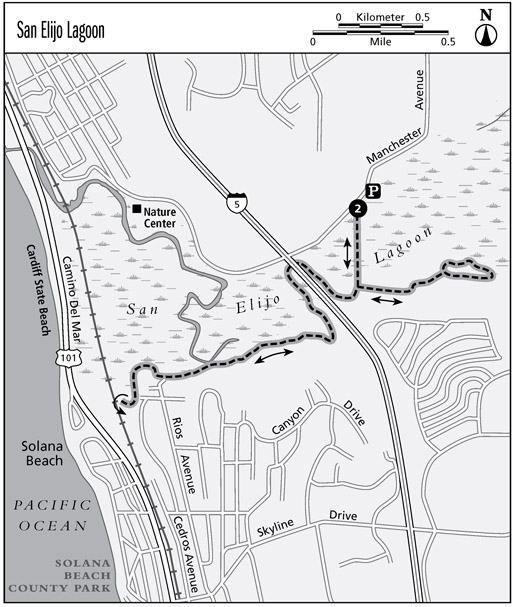
After an inauspicious beginning, with the din of the freeway in your ears, this hike becomes scenic and enjoyable. Like Batiquitos Lagoon to the north, San Elijo is an excellent location for identifying birds.
From your roadside parking, walk to the entrance and head south across the man-made causeway. Turn left at the trail junction at 0.3 mile, angling away from the noisy freeway. From here, the trail meanders alongside the lagoon and eventually reaches a hill and overlook. Enjoy the views and vantage and continue to the original trail junction. This time make two right turns, always heading for the freeway. Head under the freeway overpass on a narrow wooden bridge at 1.75 miles. Make a left (south) turn and follow the well-graded trail.
Leave the din of the freeway by traversing a hillside to the trail along the lagoon. Survey the views of the lagoon as you amble along the shore to an interpretive sign. Listen for the call of the threatened gnatcatcher (which sounds like a kitten) as you walk up into coastal sage scrub. A small acre brushfire on October 3, 2019 burned a portion of the south side of the lagoon near Rios Avenue off Holmwood Lane. The remnants are visible from the trail.
Make a right (north) turn at the gate on North Rios Avenue at 2.75 miles and head down the dirt road back into the preserve. Contour around to the western side of the lagoon, where a small trail leads up to tantalizing views of Seaside Reef and the Pacific Ocean. To get back to your car, retrace your steps through the wetlands.
0.0 Head south across the causeway.
0.3 Make a left turn and walk along the lagoon.
1.0 Reach a hill and overlook of the eastern side of the lagoon.
1.4 Continue straight at the trail junction. Make two right turns, always aiming for the freeway.
Font size:
Interval:
Bookmark:
Similar books «Best Easy Day Hikes San Diego»
Look at similar books to Best Easy Day Hikes San Diego. We have selected literature similar in name and meaning in the hope of providing readers with more options to find new, interesting, not yet read works.
Discussion, reviews of the book Best Easy Day Hikes San Diego and just readers' own opinions. Leave your comments, write what you think about the work, its meaning or the main characters. Specify what exactly you liked and what you didn't like, and why you think so.