Sarah Bell - Mapping by Design
Here you can read online Sarah Bell - Mapping by Design full text of the book (entire story) in english for free. Download pdf and epub, get meaning, cover and reviews about this ebook. year: 2021, publisher: Esri Press, genre: Home and family. Description of the work, (preface) as well as reviews are available. Best literature library LitArk.com created for fans of good reading and offers a wide selection of genres:
Romance novel
Science fiction
Adventure
Detective
Science
History
Home and family
Prose
Art
Politics
Computer
Non-fiction
Religion
Business
Children
Humor
Choose a favorite category and find really read worthwhile books. Enjoy immersion in the world of imagination, feel the emotions of the characters or learn something new for yourself, make an fascinating discovery.
- Book:Mapping by Design
- Author:
- Publisher:Esri Press
- Genre:
- Year:2021
- Rating:3 / 5
- Favourites:Add to favourites
- Your mark:
Mapping by Design: summary, description and annotation
We offer to read an annotation, description, summary or preface (depends on what the author of the book "Mapping by Design" wrote himself). If you haven't found the necessary information about the book — write in the comments, we will try to find it.
Sarah Bell: author's other books
Who wrote Mapping by Design? Find out the surname, the name of the author of the book and a list of all author's works by series.


Mapping by Design — read online for free the complete book (whole text) full work
Below is the text of the book, divided by pages. System saving the place of the last page read, allows you to conveniently read the book "Mapping by Design" online for free, without having to search again every time where you left off. Put a bookmark, and you can go to the page where you finished reading at any time.
Font size:
Interval:
Bookmark:

Transcription:
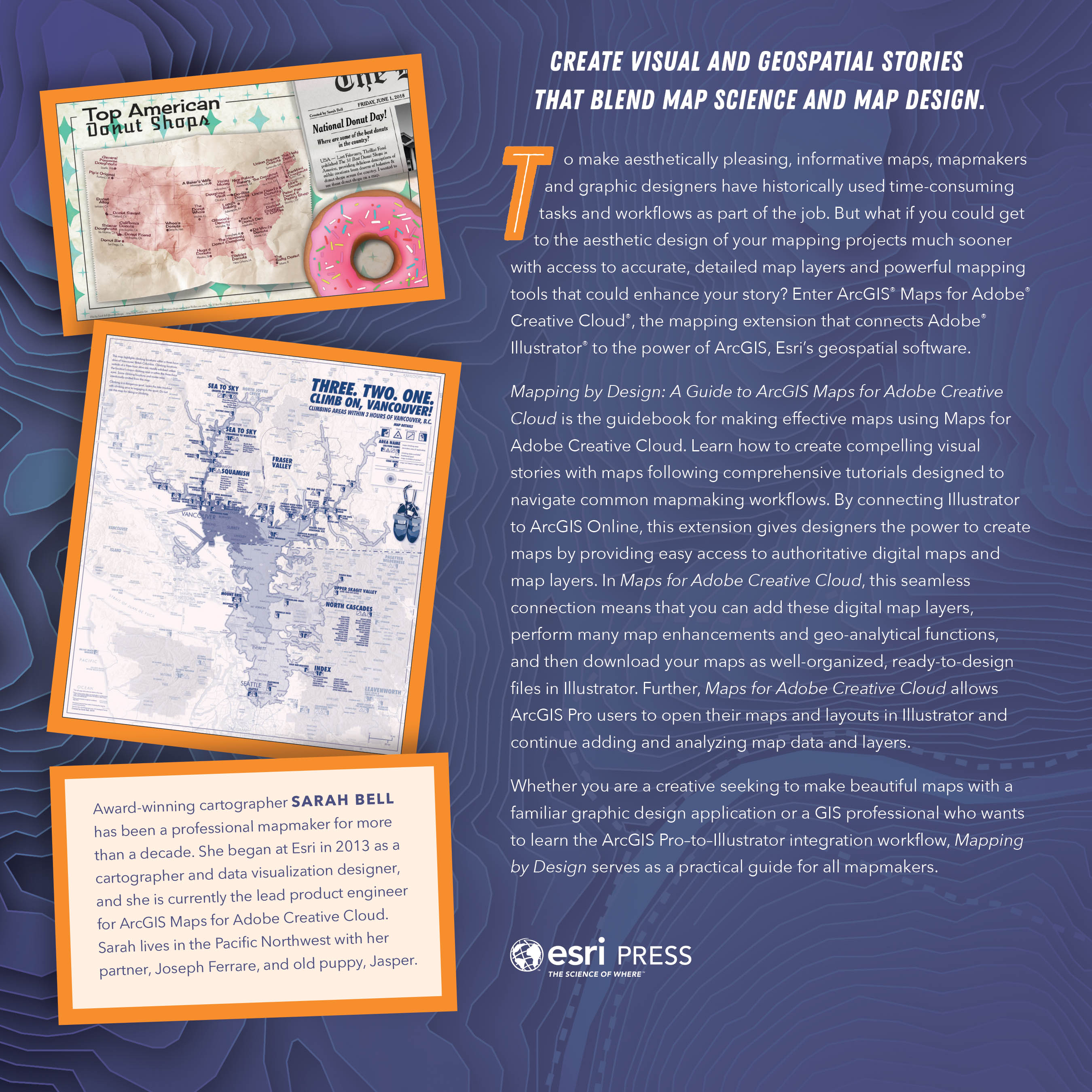
Create visual and geospatial stories that blend map science and map design.
To make aesthetically pleasing, informative maps, mapmakers and graphic designers have historically used time-consuming tasks and workflows as part of the job. But what if you could get to the aesthetic design of your mapping projects much sooner with access to accurate, detailed map layers and powerful mapping tools that could enhance your story? Enter ArcGIS Maps for Adobe Creative Cloud, the mapping extension that connects Adobe Illustrator to the power of ArcGIS, Esris geospatial software.
Mapping by Design: A Guide to ArcGIS Maps for Adobe Creative Cloud is the guidebook for making effective maps using Maps for Adobe Creative Cloud. Learn how to create compelling visual stories with maps following comprehensive tutorials designed to navigate common mapmaking workflows. By connecting Illustrator to ArcGIS Online, this extension gives designers the power to create maps by providing easy access to authoritative digital maps and map layers. In Maps for Adobe Creative Cloud, this seamless connection means that you can add these digital map layers, perform many map enhancements and geo-analytical functions, and then download your maps as well-organized, ready-to-design files in Illustrator. Further, Maps for Adobe Creative Cloud allows ArcGIS Pro users to open their maps and layouts in Illustrator and continue adding and analyzing map data and layers.
Whether you are a creative seeking to make beautiful maps with a familiar graphic design application or a GIS professional who wants to learn the ArcGIS ProtoIllustrator integration workflow, Mapping by Design serves as a practical guide for all mapmakers.
Award-winning cartographer Sarah Bell has been a professional mapmaker for more than a decade. She began at Esri in 2013 as a cartographer and data visualization designer, and she is currently the lead product engineer for ArcGIS Maps for Adobe Creative Cloud. Sarah lives in the Pacific Northwest with her partner, Joseph Ferrare, and old puppy, Jasper.
Published by Esri Press.
The ArcGIS Maps for Adobe Creative Cloud extension is made possible by a team of talented people orchestrating its development daily. I simply cannot complete a book about Maps for Adobe Creative Cloud without thanking the many people who have contributed to its growth and development. I have immense gratitude for the user community, testers, conference-goers, coworkers, and friends who have provided feedback, watched demos, or just listened to my musings on mapping. You all have positively impacted this product. Following is a list of key individuals who have played important roles in Maps for Adobe Creative Cloud. As these lists go, it is imperfectly incomplete. I thank the following:
Valerie Alcantara, Javier Angel, Anna Breton, Jino Contreras, Jordan Cullen, Debalin Das, Ixshel Escamilla, Kara Goodman, Natalie Hansen, Elena Hartley, Jennifer Hill, Wendy Kallio, Aubri Kinghorn, Manuel Lopez, Clint Loveman, Nancy Morales, Elena Maklakova, Steven Moore, Joseph Munyao, Guy Noll, Kenneth OGuinn, Rajeev Pahuja, Brandy Perkins, Madhura Phaterpekar, Siva Pidaparthi, Greg Pleiss, Salman Rafique, Alan Taylor, Vladimir Tkachov, Dmitry Travin, Rey Umali, Craig Williams, Jeremy Wright, Konstantin Yakovenko, Alan Zhang, and Xingdong Zhang.
Thanks to all the talented people at Esri Press as well.
And finally, thank you to my always supportive partner, Joseph Ferrare.
Cover map adapted from Daffodils and Homesites of the Eno River by Madalyn Baldwin, who placed in the 2020 ArcGIS Maps for Adobe competition. Two inset maps on the back cover by Sarah Bell.Esri Press, 380 New York Street, Redlands, California 92373-8100Copyright 2021 EsriAll rights reserved.ISBN: 9781589486041e-ISBN: 9781589486058The Library of Congress has cataloged the print edition as follows: 2021943194The information contained in this document is the exclusive property of Esri unless otherwise noted. This work is protected under United States copyright law and the copyright laws of the given countries of origin and applicable international laws, treaties, and/or conventions. No part of this work may be reproduced or transmitted in any form or by any means, electronic or mechanical, including photocopying or recording, or by any information storage or retrieval system, except as expressly permitted in writing by Esri. All requests should be sent to Attention: Contracts and Legal Services Manager, Esri, 380 New York Street, Redlands, California 92373-8100, USA.The information contained in this document is subject to change without notice.US Government Restricted/Limited Rights: Any software, documentation, and/or data delivered hereunder is subject to the terms of the License Agreement. The commercial license rights in the License Agreement strictly govern Licensees use, reproduction, or disclosure of the software, data, and documentation. In no event shall the US Government acquire greater than RESTRICTED/LIMITED RIGHTS. At a minimum, use, duplication, or disclosure by the US Government is subject to restrictions as set forth in FAR 52.227-14 Alternates I, II, and III (DEC 2007); FAR 52.227-19(b) (DEC 2007) and/or FAR 12.211/12.212 (Commercial Technical Data/Computer Software); and DFARS 252.227-7015 (DEC 2011) (Technical Data Commercial Items) and/or DFARS 227.7202 (Commercial Computer Software and Commercial Computer Software Documentation), as applicable. Contractor/Manufacturer is Esri, 380 New York Street, Redlands, CA 92373-8100, USA.@esri.com, 3D Analyst, ACORN, Address Coder, ADF, AML, ArcAtlas, ArcCAD, ArcCatalog, ArcCOGO, ArcData, ArcDoc, ArcEdit, ArcEditor, ArcEurope, ArcExplorer, ArcExpress, ArcGIS, ArcGIS CityEngine, arcgis.com, ArcGlobe, ArcGrid, ArcIMS, ARC/INFO, ArcInfo, ArcInfo Librarian, ArcLessons, ArcLocation, ArcLogistics, ArcMap, ArcNetwork, ArcNews, ArcObjects, ArcOpen, ArcPad, ArcPlot, ArcPress, ArcPy, ArcReader, ArcScan, ArcScene, ArcSchool, ArcScripts, ArcSDE, ArcSdl, ArcSketch, ArcStorm, ArcSurvey, ArcTIN, ArcToolbox, ArcTools, ArcUSA, ArcUser, ArcView, ArcVoyager, ArcWatch, ArcWeb, ArcWorld, ArcXML, Atlas GIS, AtlasWare, Avenue, BAO, Business Analyst, Business Analyst Online, BusinessMAP, CommunityInfo, Database Integrator, DBI Kit, EDN, Esri, esri.com, EsriTeam GIS, EsriThe GIS Company, EsriThe GIS People, EsriThe GIS Software Leader, FormEdit, GeoCollector, Geographic Design System, Geography Matters, Geography Network, geographynetwork.com, Geoloqi, Geotrigger, GIS by Esri, gis.com, GISData Server, GIS Day, gisday.com, GIS for Everyone, JTX, MapIt, Maplex, MapObjects, MapStudio, ModelBuilder, MOLE, MPSAtlas, PLTS, Rent-a-Tech, SDE, See What Others Cant, SML, SourcebookAmerica, SpatiaLABS, Spatial Database Engine, StreetMap, Tapestry, the ARC/INFO logo, the ArcGIS Explorer logo, the ArcGIS logo, the ArcPad logo, the Esri globe logo, the Esri Press logo, The Geographic Advantage, The Geographic Approach, the GIS Day logo, the MapIt logo, The Worlds Leading Desktop GIS, Water Writes, and Your Personal Geographic Information System are trademarks, service marks, or registered marks of Esri in the United States, the European Community, or certain other jurisdictions. Other companies and products or services mentioned herein may be trademarks, service marks, or registered marks of their respective mark owners.For purchasing and distribution options (both domestic and international), please visit esripress.esri.com.Mapping by Design: A Guide to ArcGIS Maps for Adobe Creative Cloud IS NOT AUTHORIZED, ENDORSED, OR SPONSORED BY ADOBE, PUBLISHER OF Adobe, Adobe Creative Cloud, Adobe Illustrator, and Adobe Photoshop.Adobe, the Adobe logo, Creative Cloud, Illustrator, and Photoshop are either registered trademarks or trademarks of Adobe Systems Incorporated in the United States and/or other countries.173431
Font size:
Interval:
Bookmark:
Similar books «Mapping by Design»
Look at similar books to Mapping by Design. We have selected literature similar in name and meaning in the hope of providing readers with more options to find new, interesting, not yet read works.
Discussion, reviews of the book Mapping by Design and just readers' own opinions. Leave your comments, write what you think about the work, its meaning or the main characters. Specify what exactly you liked and what you didn't like, and why you think so.