About the Author
Laurel Scheidt, born and raised in the central San Joaquin Valley, considers the Sierra Nevada her home away from home. She has traveled many of the trails on both sides of the mountain range; from Sonora Pass to the Golden Trout Wilderness south of Sequoia and Kings Canyon National Parks. She is well studied in the field of Wildlife and Forestry Conservation and is a member of the Audubon Society, the Nature Conservancy, the Sierra Club, and the Cornell Laboratory of Ornithology. After living most of her life in Fresno, she now resides in Modesto, California, with her husband, Scott.
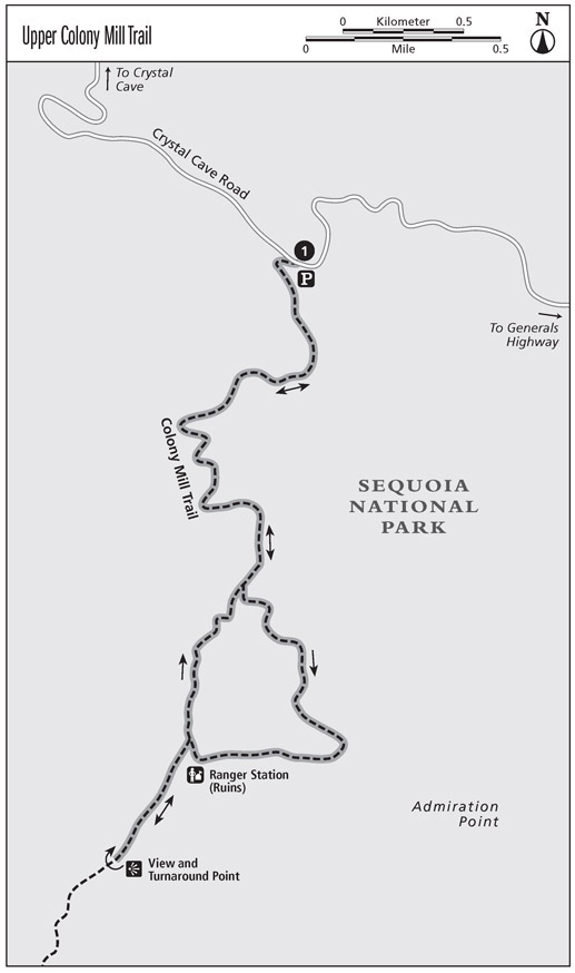
Upper Colony Mill Trail
This trek follows the old dirt road that once served as the entrance to Sequoia National Park and the Giant Forest, before the Generals Highway opened in 1926.
Distance: 5.2-mile lollipop with side trip
Approximate hiking time: 3.5 hours
Difficulty: Moderate, due to overgrown sections of trail
Trail surface: Dirt
Best season: May through early Oct
Canine compatibility: Dogs not permitted
Fees and permits: Park entrance fee; no permit required
Schedule: Gate west of the Marble Fork Bridge closes at 5:00 p.m. This gate is locked when Crystal Cave is closed for the season and may be locked at other times (refer to the signs at the turnoff).
Maps: USGS Giant Forest
Trail contacts: Sequoia and Kings Canyon National Parks, 47050 Generals Hwy., Three Rivers, CA 93271-9700; (559) 565-3341; www.nps.gov/seki; Foothills Visitor Center, 1 mile north of the Ash Mountain entrance station
Special considerations: The parking area at this trailhead is very small; there are no restrooms or water.
Finding the trailhead: On the Generals Highway drive 13.8 miles north from the Ash Mountain entrance station, or 4.2 miles south from the General Sherman Tree area, to Crystal Cave Road. Turn onto the road and drive west for 4.1 miles, passing the Marble Fork Bridge. The small Colony Mill parking area is located on the left (south) side of the road. GPS: N36 34.15 / W118 48.25
The Hike
The old park entrance road leads west then curves south, dropping slightly through dogwoods and a shady mixed forest. Striking wild iris sometimes grows in the middle of the track. The wide path curves toward the southeast, climbing gently below Colony Peak. At the trail junction at 1.4 miles, keep left (southeast). The overgrown road to the right is your return route.
After crossing over a small ridge, the trail descends to a view above Admiration Point. Beneath you is Marble Falls, though it may not be visible through the brush growing wildly on the hillside. In the east stand the peaks of the Great Western Divide, with Moro Rock in the foreground.
The trail curves west, through chemise, manzanita, and wildflowers in spring. At 2.4 miles you arrive at the old entrance station to Sequoia National Park. The dilapidated Colony Mill Ranger Station is obviously no longer in use. The road below this point was constructed mainly with hand tools by a utopian group known as the Kaweah Colonists. They erected an infamous portable sawmill nearby in order to log the Giant Forest. In 1890 the establishment of Sequoia National Park thwarted the Colonists plans. Thirteen years later the U.S. Cavalry extended the road (where youve been hiking) to the Giant Forest, making this the main route into the park until the Generals Highway opened in 1926.
The trail continues past toppled outhouses to the junction with your return route at 2.5 miles. Take the left (southwest) fork to the view above Panorama Point for more vistas to the east at 2.9 miles. Two abandoned trails lead off from this point: One climbs to the highest point on Ash Peaks Ridge, where a fire lookout was once located; the other heads downhill to the Generals Highway via Elk Creek. Both trails are now too overgrown for use. The Colony Mill Trail continues for another 7.0 miles west to North Fork Drive.
Retrace your steps to the junction with your return trail, now 3.3 miles into the hike. Keep left (north) at the fork and follow the overgrown route over the ridge. You may see mountain quail with their chicks and other wildlife in this lightly traveled area. At the junction with the main trail at 3.8 miles, turn left (north) and return to the parking area at 5.2 miles.
Option
If you want to avoid any bushwhacking, turn around at Panorama Point and return the way you came for a 5.8-mile out-and-back hike.
Miles and Directions
0.0 Start at the trailhead.
1.4 Reach the trail fork and make a left.
2.4 Arrive at the ruins of the old ranger station.
2.5 Reach the second trail fork and make a left for the side trip.
2.9 Take in the views above Panorama Point. (Option: Backtrack from the point for a 5.8-mile out-and-back hike.)
3.3 Return to the previous trail junction and bear left.
3.8 Reach the first trail junction; turn left and head toward the trailhead.
5.2 Arrive back at the trailhead.
Crescent and Log Meadows
This partially paved route takes you past one of John Muirs favorite meadows and to a real log cabin. Wildlife frequents these meadows, and deer and bear sightings are common.
Distance: 1.7-mile loop
Approximate hiking time: 1 hour
Difficulty: Easy
Trail surface: Partially paved/dirt
Best season: June through Oct
Canine compatibility: Dogs not permitted
Fees and permits: Park entrance fee; no permit required
Maps: USGS Giant Forest; Sequoia National Park Giant Forest (available at park visitor centers)
Trail contacts: Sequoia and Kings Canyon National Parks, 47050 Generals Hwy., Three Rivers, CA 93271-9700; (559) 565-3341; www.nps.gov/seki; Giant Forest Museum, 16 miles north of the Ash Mountain entrance station
Special considerations: Restrooms, water, and a picnic area are all available at this trailhead. Crescent Meadow Road is closed to private vehicles on weekends and holidays May 24th to September 9th. A shuttle to the trailhead runs from 8 a.m. to 6 p.m. to provide access.
Finding the trailhead: On the Generals Highway, drive 15.9 miles north from the Ash Mountain entrance station, or 2.1 miles south from the General Sherman Tree area, to Crescent Meadow Road. Turn east and follow the narrow, winding road for 2.5 miles to its end at the Crescent Meadow parking area, passing the Moro Rock turnoff along the way. The trail begins at the southeast end of the parking area, just south of the restrooms. GPS: N36 33.17 / W118 44.56
The Hike
The paved path that begins this jaunt coincides with the start of the High Sierra Trail. After crossing Crescent Creek on two wooden footbridges, you take the left (east) fork, leaving the celebrated trans-Sierra route, which continues to Eagle View and then heads into the backcountry. A large sign at the end of Crescent Meadow proclaims it the Gem of the Sierra, a quote from John Muir. Wildflowers bloom amidst the green and yellow grasses. Shooting stars and leopard lilies appear in early season, lavender lupines in the middle of summer, and bright spears of meadow goldenrods near summers end.
The trail travels north along the southeast rim of the meadow. At 0.3 mile a dirt track leads left (north) to the Cleveland and Chimney Trees. Continue northeast on the paved path through the forest. Another dirt trail on the right loops around the east side of Log Meadow. Stay on the paved path as it takes you along the west side of Log Meadow, where, if the trail is not crowded, you may spot a bear or a doe with her young. Yellow-rumped and orange-crowned warblers often flit about in the trees above the trail.


