50 Hikes in the Tillamook and Clatsop State Forests
Sierra Club Oregon Chapter
Ooligan Press
Portland, Oregon
50 Hikes in the Tillamook and Clatsop State Forests
2018 Sierra Club Oregon Chapter
ISBN13: 978-1-932010-96-1
All rights reserved. No part of this book may be reproduced or transmitted in any form or by any means, electronic or mechanical, including photocopying, recording, or by any information storage and retrieval system, without permission in writing from the publisher.
Ooligan Press
Portland State University
Post Office Box 751, Portland, Oregon 97207
503.725.9748
ooligan@ooliganpress.pdx.edu | www.ooliganpress.pdx.edu
Library of Congress Cataloging-in-Publication Data
Names: Sierra Club. Oregon Chapter, contributing body.
Title: 50 hikes in the Tillamook and Clatsop State forests.
Other titles: Fifty hikes in the Tillamook and Clatsop State forests
Description: Portland, Oregon : Ooligan Press, Portland State University, 2018. | Sierra Club, Oregon ChapterCover. | Includes index.
Identifiers: LCCN 2017043908 | ISBN 9781932010961 (pbk.)
Subjects: LCSH: HikingOregonTillamook State ForestGuidebooks. | HikingOregonClatsop State ForestGuidebooks. | TrailsOregonTillamook State ForestGuidebooks. | TrailsOregonClatsop State ForestGuidebooks | Tillamook State Forest (Or.)Guidebooks. | Clatsop State Forest (Or.)Guidebooks.
Classification: LCC GV199.42.O72 T583 2018 | DDC 796.5109795/44dc23
LC record available at https://lccn.loc.gov/2017043908
Cover design by Andrea McDonald
Interior design by Hope Levy
Index by Kento Ikeda
References to website URLs were accurate at the time of writing. Neither the author nor Ooligan Press is responsible for URLs that have changed or expired since the manuscript was prepared.
Printed in the United States of America
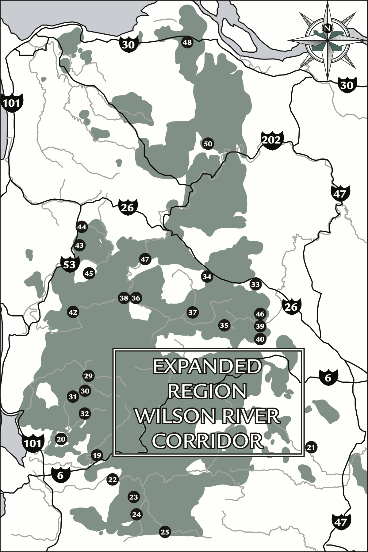
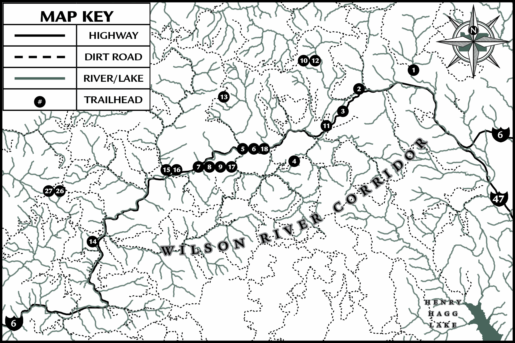
Wilson River Corridor
- Wildcat Mountain
- Gales Creek
- Gales Creek Summit
- University Falls
- Elk Creek
- Elk MountainElk Creek Loop
- Kings Mountain
- Elk MountainKings Mountain Traverse
- Kings Mountain Junior
- Larch MountainBell Camp Road
- Larch MountainStorey Burn Road
- East Standard Grade Road
- West Standard Grade Road to Blue Lake
- Keenig Creek to Footbridge
- Jones Creek Day Use Area to Footbridge
- Jones Creek to Diamond Mill
- Kings Mountain to Diamond Mill
- Elk Creek to Kings Mountain
- Little North Fork of the Wilson (Lower River Trail)
- Triangulation Point
Trask-Tualatin Drainage
- Henry Hagg Lake
- The Peninsula Trail
- Gold Peak
- Steampot Creek
- Joyce Creek
Miami-Kilchis Drainage
- Cedar Butte
- Feldshaw Ridge
- Sawtooth Ridge
- West End of Sawtooth Ridge
- Company Creek
- Kilchis River
- Little South Fork Kilchis River
Salmonberry-Nehalem Drainage
- Four County Point Trail
- Steam Donkey Trails
- Pennoyer Creek and Salmonberry River
- North Fork of the Salmonberry to Enright
- North Fork of the Salmonberry to Wolf Creek Flats
- Lower Salmonberry Trail
- Step Creek
- Giveout Mountain Scenic Drive
- Upper Lost Creek Ridge
- Nehalem Falls Loop
- Soapstone Lake
- North Fork Nehalem River
- Gods Valley
- Triple C Trail
Clatsop State Forest
- Spruce Run Creek Trail
- Gnat Creek Trail
- Bloom Lake
- Northrup Creek Equestrian Loop Trail
Non-Liability Statement
While we have made a considerable effort to check the accuracy of information in this book, errors and omissions may still occur. Changes may also happen on the land, and some descriptions that were accurate when written may be inaccurate when you read this book. One storm or logging truck, for example, can block a road, or the Oregon Department of Forestry may obliterate or change a trail.
In addition, hiking, climbing, biking, and driving in forests (especially near timber sale sites) are inherently dangerous activities. The final judgment and decision to pursue outdoor activities is always your responsibility as the user of this book. It is your responsibility to acquire the necessary skills and abilities. You must be physically fit before attempting any of the hikes described here. You must decide whether a road or trail and the weather conditions are safe for you to start or continue a trip. Road and trail conditions continually change due to timber sale activity, flooding, erosion and other natural or human-caused events. Logging and gravel trucks may meet you on forest roads. You must decide for yourself whether conditions are safe and whether you have the skills and fitness to do the hikes in this book. This book is meant only to inform and inspire.
The authors, publishers and all those associated with this publication, directly or indirectly, assume no responsibility for any accident, injury, damage or loss whatsoever that may occur to anyone using this book. The responsibility for good health and safety while hiking or driving to a hike is yours and yours alone.
Foreword
The names Clatsop and Tillamook apply not only to the two state forests this guide is about but to the counties the forests are in and our ancestral people, the Clatsop tribe and various bands of the larger Tillamook language groupNehalem, Tillamook Bay, Nestucca, Neachesna (Salmon River), and Siletz (Neslets) bands of Tillamook Indians. The state forests and the lands surrounding them are their home, their gardens, their grocery, their medicine cabinet. Thousands of years of interactions between people and the land created mosaic landscapes of ancient forests, early and mid-seral forests, and open headlands, ridgetops, and meadows. Frequently applied, low-intensity fires (at proper times) maintained a prosperous and biodiverse landscape for the benefit of all.
Our Clatsop people are most known for their interactions with the Lewis and Clark party. The fort the party built and occupied in Clatsop territory over the winter of 180506 bore the name Fort Clatsop. Few people, excepting a small number of Northwest Indian basketry enthusiasts, know that Clatsop basketry is some of the finest wrapped-twine basketry there is, and the work was only accomplished with materials gathered from sandy beaches and tide pools to lofty summits. Additional weaving techniques using other materials round out a rich tradition of fiber arts for our ancestors from the south bank at the mouth of the Columbia and nearby uplands north of Tillamook Head.
Not to be left out, our Tillamook basketry rivals that of their near neighbors to the north and resembles it closely. The Tillamook peoples wrought finely woven treasure baskets and tough utilitarian wares with materials from patches that their ancestors also maintained, enhanced, and gathered from.
Since the loss of lands through solemn promises not kept, these ancestral landscapes have been undeniably altered by road building and other development, harvest of the biggest and most ancient stands of timber, then the catastrophic fires of the early-mid 1900s (the Tillamook Burn), and, when the smokes cleared, the gargantuan efforts to restore an overcooked ecosystem. The objective was to plant and promote regrowth of the most merchantable timber species: Douglas-fir (Oregons state tree). The diversity of forest species was reduced with that effort, but it is being reclaimed with todays restoration efforts. There remain many hints of the original grandness of these northwest Oregon wondersthe landscapes and the forests. With each year that passes since the Tillamook Burn era, those memories, that legacy, come back into clearer focus through the mists of time carried on coastal breezes.

