The Official U.S. Army Map Reading and Land Navigation Handbook
Here you can read online The Official U.S. Army Map Reading and Land Navigation Handbook full text of the book (entire story) in english for free. Download pdf and epub, get meaning, cover and reviews about this ebook. year: 2022, publisher: Lyons Press, genre: Home and family. Description of the work, (preface) as well as reviews are available. Best literature library LitArk.com created for fans of good reading and offers a wide selection of genres:
Romance novel
Science fiction
Adventure
Detective
Science
History
Home and family
Prose
Art
Politics
Computer
Non-fiction
Religion
Business
Children
Humor
Choose a favorite category and find really read worthwhile books. Enjoy immersion in the world of imagination, feel the emotions of the characters or learn something new for yourself, make an fascinating discovery.

- Book:The Official U.S. Army Map Reading and Land Navigation Handbook
- Author:
- Publisher:Lyons Press
- Genre:
- Year:2022
- Rating:5 / 5
- Favourites:Add to favourites
- Your mark:
The Official U.S. Army Map Reading and Land Navigation Handbook: summary, description and annotation
We offer to read an annotation, description, summary or preface (depends on what the author of the book "The Official U.S. Army Map Reading and Land Navigation Handbook" wrote himself). If you haven't found the necessary information about the book — write in the comments, we will try to find it.
Unknown: author's other books
Who wrote The Official U.S. Army Map Reading and Land Navigation Handbook? Find out the surname, the name of the author of the book and a list of all author's works by series.


The Official U.S. Army Map Reading and Land Navigation Handbook — read online for free the complete book (whole text) full work
Below is the text of the book, divided by pages. System saving the place of the last page read, allows you to conveniently read the book "The Official U.S. Army Map Reading and Land Navigation Handbook" online for free, without having to search again every time where you left off. Put a bookmark, and you can go to the page where you finished reading at any time.
Font size:
Interval:
Bookmark:
A sketch is a free-hand drawing of a map or picture of an area or route of travel. It shows enough detail and has enough accuracy to satisfy special tactical or administrative requirements.
Sketches are useful when maps are not available or the existing maps are not adequate, or to illustrate a reconnaissance or patrol report. Sketches may vary from hasty to complete and detailed, depending upon their purpose and the degree of accuracy required. For example, a sketch of a large minefield will require more accuracy than a hasty sketch of a small unit's defensive position.
The scale of a sketch is determined by the object in view and the amount of detail required to be shown. The sketch of a defensive position for a platoon or company will normally call for a sketch of larger scale than a sketch for the same purpose for a division. A field sketch () must show the north arrow, scale, legend, and the following features:
- Power lines.
- Rivers.
- Main roads.
- Towns and villages.
- Forests.
- Rail lines.
- Major terrain features.
Military sketches include road and area sketches.
a. Road sketches show the natural and military features on and in the immediate vicinity of the road. In general, the width of terrain sketches will not exceed 365 meters on each side of the road. Road sketches may be used to illustrate a road when the existing map does not show sufficient detail.
b. Area sketches include those of positions, OPs, or particular places.
(1) Position sketch. A position sketch is one of a military position, campsite, or other area of ground, To effectively complete a position sketch, the sketcher must have access to all parts of the area being sketched.
(2) Observation post sketch. An OP sketch shows the military features of ground along a friendly OP line as far toward the enemy position as possible.
(3) Place sketch. A place sketch is one of an area made by a sketcher from a single point of observation. Such a sketch may cover ground in front of an OP line, or it may serve to extend a position or road sketch toward the enemy.
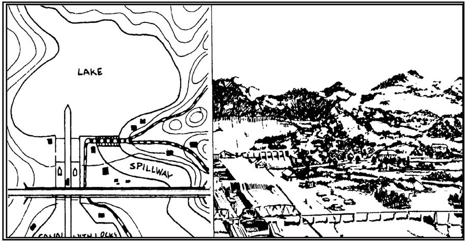
Figure A-1. Sketch map.
One of the first considerations in the care of maps is its proper folding.
show ways of folding maps to make them small enough to be carried easily and still be available for use without having to unfold them entirely.
After a map has been folded, it should be pasted in a folder for protection. Apply adhesive to the back of the segments corresponding to A, F, L, and Q ().
It is suggested that before attempting to cut and fold a map in the manner illustrated in , make a practice cut and fold with a piece of paper.
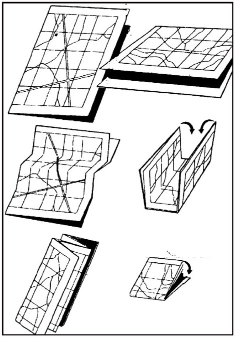
Figure B-1. Two methods of folding a map.
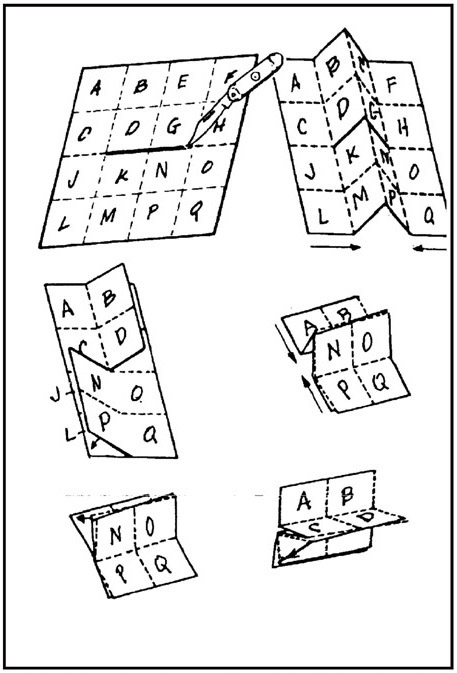
Figure B-2. How to slit and fold a map for special use.
| ENGLISH SYSTEM OF LINEAR MEASURE | ||
| 12 inches | = | 1 foot |
| 36 inches | = | 1 yard |
| 3 feet | = | 1 yard |
| 1,760 yards | = | 1 mile statute |
| 2,026.8 yards | = | 1 mile nautical |
| 5,280 feet | = | 1 mile statute |
| 6,080.4 feet | = | 1 mile nautical |
| 63,360 inches | = | 1 mile statute |
| 72,963 inches | = | 1 mile nautical |
METRIC SYSTEM OF LINEAR MEASURE | ||||
| 1 millimeter | = | 0.1 centimeter | = | 0.0393 inch |
| 10 millimeters | = | 1.0 centimeter | = | 0.3937 inch |
| 10 centimeters | = | 1.0 decimeter | = | 3.937 inches |
| 10 decimeters | = | 1.0 meter | = | 39.37 inches |
| 10 meters | = | 1.0 decameter | = | 32.81 feet |
| 10 decameters | = | 1.0 hectometer | = | 328.1 feet |
| 10 hectometers | = | 1.0 kilometer | = | 0.62 mile |
| 10 kilometers | = | 1.0 myriameter | = | 6.21 miles |
EQUIVALENT UNITS OF ANGULAR MEASURE | ||||||
| 1 mil | = | 1/6400 circle | = | 0.05625 | = | 0.0625 grad |
| 1 grad | = | 1/400 circle | = | 16.0 mils | = | 054' = 0.9 |
| 1 degree | = | 1/360 circle | = | about 17.8mils | = | about 1.1 grad |
CONVERSION FACTORS | ||||||
One | Inches | Feet | Yards | Statute Miles | Nautical Miles | mm |
| Inch | 1 | 0.0833 | 0.0277 | 25.40 | ||
| Foot | 12 | 1 | 0.333 | 304.8 | ||
| Yard | 36 | 3 | 1 | 0.00056 | 914.4 | |
| Statute Mile | 63,360 | 5,280 | 1,760 | 1 | 0.8684 | |
| Nautical Mile | 72,963 | 6,080 | 2,026 | 1.1516 | 1 | |
| Millimeter | 0.0394 | 0.0033 | 0.0011 | 1 | ||
| Centimeter | 0.3937 | 0.0328 | 0.0109 | 10 | ||
| Decimeter | 3.937 | 0.328 | 0.1093 | 1,00 | ||
| Meter | 39.37 | 3.2808 | 1.0936 | 0.0006 | 0.0005 | 1,000 |
| Decameter | 393.7 | 32.81 | 10.94 | 0.0062 | 0.0054 | 10,000 |
| Hactometer | 3,937 | 328.1 | 109.4 | 0.0621 | 0.0539 | 100,000 |
| Kilometer | 39,370 | 3,281 | 1,094 | 0.6214 | 0.5396 | 1,000,000 |
| Myriameter | 393,700 | 32,808 | 10,936 | 6.2137 | 5.3959 | 10,000,000 |
One | cm | dm | m | dkm | hm | km | mym |
| Inch | 2.540 | 0.2540 | 0.0254 | 0.0025 | 0.0003 | ||
| Foot | 30.48 | 3.048 | 0.3048 | 0.0305 | 0.0030 | 0.0003 | |
| Yard | 91.44 | 9.144 | 0.9144 | 0.0914 | 0.0091 | 0.0009 | |
| Statute Mile | 160,930 | 16,093 | 1,609 | 160.9 | 16.09 | 1.6093 | 0.1609 |
| Nautical Mile | 185,325 | 18,532 | 1,853 | 185.3 | 18.53 | 1.8532 |
Font size:
Interval:
Bookmark:
Similar books «The Official U.S. Army Map Reading and Land Navigation Handbook»
Look at similar books to The Official U.S. Army Map Reading and Land Navigation Handbook. We have selected literature similar in name and meaning in the hope of providing readers with more options to find new, interesting, not yet read works.
Discussion, reviews of the book The Official U.S. Army Map Reading and Land Navigation Handbook and just readers' own opinions. Leave your comments, write what you think about the work, its meaning or the main characters. Specify what exactly you liked and what you didn't like, and why you think so.