coll. - Map Reading and Land Navigation: Army Study Guide
Here you can read online coll. - Map Reading and Land Navigation: Army Study Guide full text of the book (entire story) in english for free. Download pdf and epub, get meaning, cover and reviews about this ebook. City: Washington, D. C., year: 2017, publisher: U.S. Dept of Defense, genre: Science. Description of the work, (preface) as well as reviews are available. Best literature library LitArk.com created for fans of good reading and offers a wide selection of genres:
Romance novel
Science fiction
Adventure
Detective
Science
History
Home and family
Prose
Art
Politics
Computer
Non-fiction
Religion
Business
Children
Humor
Choose a favorite category and find really read worthwhile books. Enjoy immersion in the world of imagination, feel the emotions of the characters or learn something new for yourself, make an fascinating discovery.
Map Reading and Land Navigation: Army Study Guide: summary, description and annotation
We offer to read an annotation, description, summary or preface (depends on what the author of the book "Map Reading and Land Navigation: Army Study Guide" wrote himself). If you haven't found the necessary information about the book — write in the comments, we will try to find it.
coll.: author's other books
Who wrote Map Reading and Land Navigation: Army Study Guide? Find out the surname, the name of the author of the book and a list of all author's works by series.


Map Reading and Land Navigation: Army Study Guide — read online for free the complete book (whole text) full work
Below is the text of the book, divided by pages. System saving the place of the last page read, allows you to conveniently read the book "Map Reading and Land Navigation: Army Study Guide" online for free, without having to search again every time where you left off. Put a bookmark, and you can go to the page where you finished reading at any time.
Font size:
Interval:
Bookmark:
- What is the Field Manual for map reading and land navigation?
FM 3-25.26 - What are the basic colors of a map, and what does each color represent?
- Black - Indicates cultural (man-made) features such as buildings and roads, surveyed spot elevations, and all labels.
- Red-Brown - The colors red and brown are combined to identify cultural features, all relief features, non-surveyed spot elevations, and elevation, such as contour lines on red-light readable maps.
- Blue - Identifies hydrography or water features such as lakes, swamps, rivers, and drainage.
- Green - Identifies vegetation with military significance, such as woods, orchards, and vineyards.
- Brown - Identifies all relief features and elevation, such as contours on older edition maps, and cultivated land on red-light readable maps.
- Red - Classifies cultural features, such as populated areas, main roads, and boundaries, on older maps.
- Other - Occasionally other colors may be used to show special information. These are indicated in the marginal information as a rule.
- What are military symbols?
Figures used to represent types of military organizations, installations, and activities - Where is the Legend of the map found?
Lower left margin - What are contour lines?
Imaginary lines on the ground connecting equal elevation, they represent high and low ground elevation. - What are 3 types of contour lines?
- Index
- Intermediate
- Supplementary
- How many Mils are in one Degree?
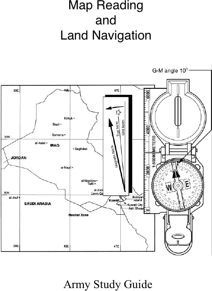
17.7 mils - How many Norths are there on a military map?
Three: - True north
- Magnetic north
- Grid north
- What shape are the contour lines that indicate a hill?
A hill is shown on a map by contour lines forming concentric circles. The inside of the smallest closed circle is the hilltop.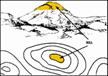
- What shape are the contour lines that indicate a saddle?
A saddle is normally represented as an hourglass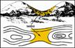
- What shape are the contour lines that indicate a valley?
Contour lines forming a valley are either U-shaped or V-shaped.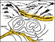
- What shape are the contour lines that indicate a Ridge?
Contour lines forming a ridge tend to be U-shaped or V-shaped. The closed end of the contour line points away from high ground.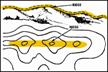
- What shape are the contour lines that indicate a depression?
Usually only depressions that are equal to or greater than the contour interval will be shown. On maps, depressions are represented by closed contour lines that have tick marks pointing toward low ground.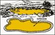
- What shape are the contour lines that indicate a draw?
The contour lines depicting a draw are U-shaped or V-shaped, pointing toward high ground.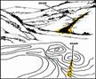
- What shape are the contour lines that indicate a spur?
Contour lines on a map depict a spur with the U or V pointing away from high ground.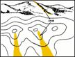
- What shape are the contour lines that indicate a cliff?
Cliffs are also shown by contour lines very close together and, in some instances, touching each other.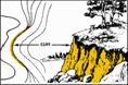
- What shape are the contour lines that indicate a cut?
This contour line extends the length of the cut and has tick marks that extend from the cut line to the roadbed, if the map scale permits this level of detail. - What shape are the contour lines that indicate a fill?
This contour line extends the length of the filled area and has tick marks that point toward lower ground. If the map scale permits, the length of the fill tick marks are drawn to scale and extend from the base line of the fill symbol. - What must be done to a map before it can be used?
It must be oriented. - What are 5 major terrain features found on a map?
- Hill
- Ridge
- Valley
- Saddle
- Depression
- What are the 3 minor terrain features found on a military map?
- Draw
- Spur
- Cliff
- What are the 2 supplementary terrain features found on a military map?
- Cut
- Fill
- What is a map?
A map is a graphic representation of a portion of the earths surface drawn to scale, as seen from above. - What is an azimuth?
A horizontal angle, measured in a clockwise manner from a north base line, expressing direction. - What is vertical distance?
The distance between the highest and lowest points measured. - What is a contour interval?
The vertical distance between adjacent contour lines on a map. - What is the distance between grid lines on a combat map?
1 kilometer or 1000 meters - How many mils are there in a circle?
6400 mils in 360 degrees - Which north is used when using a military map?
Magnetic north when using a compass, and grid north when using the map - How would you hold a lensatic compass?
Away from metal (weapons, electrical devices), level and firm - Name two ways to hold a compass?
- Compass-to-Cheek Method
- Center-Hold Method
- Are topographic symbols drawn to scale?
No - What do topographic symbols represent?
Man-made and natural features - In military symbols, what colors are used for a map overlay and what do they represent?
- Blue- Friendly forces
- Red-Enemy forces
- Black- boundaries
- Yellow-contaminated area both friendly and enemy
- Green- engineer obstacles, both friendly and enemy
- Blue- Friendly forces
- What is Back Azimuth?
The opposite direction of an azimuth. - How do you figure out a back azimuth?
To obtain a back azimuth from an azimuth, add 180 degrees if the azimuth is 180 degrees or less; subtract 180 degrees if the azimuth is 180 degrees or more - What is a declination diagram?
Shows the angular relationship between the magnetic north, grid north and true north - What is the general rule for reading military grid coordinates?
Right and UP - How many sights does a compass have?
2 - What is a benchmark?
A man-made marker showing points of elevation - What are parallels of latitude?
Measured distances going north or south of the equator - What is an aerial photograph?
An aerial photograph is any photograph taken from an airborne vehicle (aircraft, drones, balloons, satellites, and so forth)
Font size:
Interval:
Bookmark:
Similar books «Map Reading and Land Navigation: Army Study Guide»
Look at similar books to Map Reading and Land Navigation: Army Study Guide. We have selected literature similar in name and meaning in the hope of providing readers with more options to find new, interesting, not yet read works.
Discussion, reviews of the book Map Reading and Land Navigation: Army Study Guide and just readers' own opinions. Leave your comments, write what you think about the work, its meaning or the main characters. Specify what exactly you liked and what you didn't like, and why you think so.