IMAGES
of America
OLD CUCAMONGA
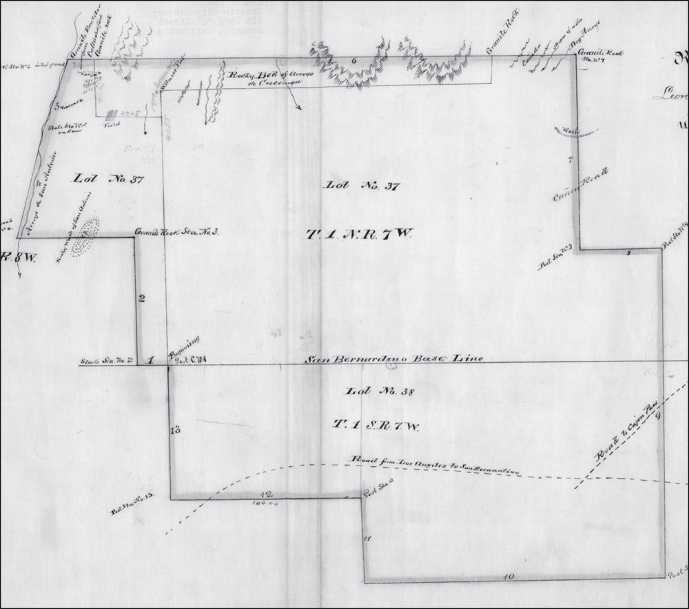
This 1865 survey map shows the borders of the Cucamonga Rancho that John and Maria Rains purchased from the heirs of Tiburcio Tapia. Todays city borders are very close to these original lines. Only two roads are shown here: the road from Los Angeles to San Bernardino, and the road to the Cajon Pass. The perfectly straight San Bernardino Base Line across the center was established by surveyors for measurement purposes. Today, it is the well-traveled Baseline Road. (Authors collection.)
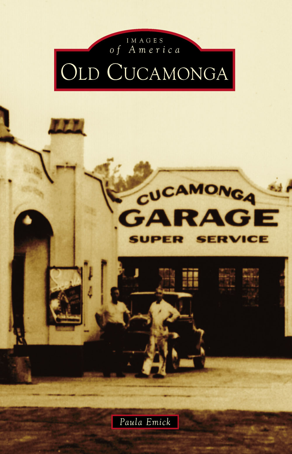
ON THE COVER: The Atlantic Richfield station was one of first gas stations in Cucamonga, and it remains a noted landmark on Foothill Boulevard. It was built in 1914 and operated until 1972. The station remained abandoned for decades. The Route 66 Inland Empire California, a nonprofit group, began restoration of the station in 2013 to create a Route 66 museum. (Ed Dietl.)
IMAGES
of America
OLD CUCAMONGA
Paula Emick

Copyright 2015 by Paula Emick
ISBN 978-1-4671-3313-5
Ebook ISBN 9781439654484
Published by Arcadia Publishing
Charleston, South Carolina
Library of Congress Control Number: 2014949899
For all general information, please contact Arcadia Publishing:
Telephone 843-853-2070
Fax 843-853-0044
E-mail
For customer service and orders:
Toll-Free 1-888-313-2665
Visit us on the Internet at www.arcadiapublishing.com
To my ever-patient husband and family.
CONTENTS
ACKNOWLEDGMENTS
This book would not have been possible without the assistance of many wonderful people. The City of Rancho Cucamonga has been very supportive of both of my books. To the longtime residents who responded to notes and newspaper and Facebook announcements and came to Local History Night clutching your family history for me to scan, thank you. Thanks go to Elaine Craig, Linda Eddy, Pam Langmaack, Tim McCanless, Claudia Perdew, Maggie and Will Plunkett, and Karen Stanphil, for volunteering to share family photographs with the public.
Thank you, to Mary and Emily Blatnick, Sammy Dominick, Jackie Jeffers, Caroline Owens and Rosemary Owens, Al Scorsatto, Bill Yamaguchi, and Bob VanOosting, who each spent several hours sharing their photographs and stories. Special thanks go to the Filippi and Biane families, who have carried on their family legacies and preserved Cucamongas wine history. You were very accommodating to my questions and requests. Kelly Zackman and the staff of the Ontario Model Colony History Room are always helpful in locating just the right picture for me.
Once again, I am indebted to Lucille Thompson and Shirley OMorrow for the generous use of so many of the Stipe family photographs and for taking time to answer questions. Thanks go to Ed Dietl for his help and photographsand for trying to understand my writing process. A big thank-you also goes to Marilyn Anderson of the Cooper Museum. You are so gracious to my last-minute questions and searches for information. I have learned a lot from you. I owe a huge debt of gratitude to a new history friend, Jane Vath OConnell, who was a never-ending source of information and photographs, as well as a few laughs.
There is a special lady in the Northtown Community Center, Carol Norris, its boards president. When she is not helping the children and families of Northtown, she is working to preserve that communitys history. She gave time from her extraordinarily busy schedule to assist me with this project. I wish her luck on her own book about Northtown.
Photographs without a credit line come from the authors collection. Photographs obtained from the Ontario Librarys Robert E. Ellingwood Model Colony History Room are credited as Ontario Library; those from the Cooper Regional History Museum are credited as Cooper Museum.
Lastly, a special thank-you goes to all the Rancho Cucamonga schoolteachers, including Dustin Guerra, who teach local history to their students so future generations will know the roots of this great city.
INTRODUCTION
Rancho Cucamongas population has exploded since the three small towns of Etiwanda, Alta Loma, and Cucamonga incorporated into one city in 1977. What was it like before the land boom? In 1970, the population of Cucamonga was a mere 5,796 persons, and in 1950, it was just 1,255. Not everything and everyone in Cucamongas history can be shown in one book. This small book of photographs is meant to give readers a snapshot of what life was like in Old Cucamonga.
Only the town of Cucamonga will be covered in this volume. Generally speaking, the borders of Cucamonga are roughly Baseline Road on the north, Vineyard Avenue on the west, Milliken Avenue on east, and Fourth Street on the south. Confusion can arise when looking at old documents, as the whole area including Ontario and east toward Riverside was called Cucamonga or the Cucamonga Wine Valley. Also, a winery could be referred to as the Cucamonga Winery, meaning it was a winery located in Cucamonga, or a winery called Cucamonga Winery, whether or not that was its actual name. Add to that the fact that many wineries had Cucamonga in their official names. Research can become baffling. Then, there is the fact that North Cucamonga, or Northtown, is in the southern half of town. The area of South Cucamonga is in north Ontario. To clarify, Cucamonga Wine Valley extended south into present-day Ontario. That area is now called Guasti, named after the man who owned a very large vineyard and winery there in the 1900s. Back then, though, that area was called South Cucamonga. Many of its laborers lived in a community north of Guasti, hence North Cucamonga, or Northtown. Another large winery, the Padre Winery, also lay to the north of Guasti and was designated a North Cucamonga winery. Everyone understand?
The real history of Cucamonga begins long before the maps were drawn. The Los Angeles basin was home to Native Americans who called themselves the Tongva. Each tribe was an extended family unit of 20 to 100 people with its own name. Remnants of a Cucamonga village were found when Alta High School was built. The name refers both to the people and the land. Sometimes, the word is spelled Kucomongo or Kucamonga to differentiate it from modern Cucamonga. The suffix -nga, seen on many area names, means place of in Tongva. For instance, Tujunga means old womans place, as in Mother Earth. Temecula, a variation of Temeekunga, means place of the sun. Pechanga means place where the water drips, and Cucamonga means place of many waters or sandy place.
Cucamongas many waters came from the seasonal mountain streams that flood the land before sinking into the sandy soil of the valley floor. Flooding from the Cucamonga Creek over thousands of years brought rocks and sand down the hillsides and across the land. When the Spanish traveled through this area to colonize Alta California in the 1700s, they met the Kucomongo and discovered that the streams made an excellent rest stop after crossing the Mojave Desert.
The string of 21 California missions was operated by the Spanish from 1769 to 1833. For the pueblo of Los Angeles, there was the Mission San Gabriel Archangel, whose lands extended west and south to the Pacific Ocean and east to San Bernardino. The Tongva who were taken there to live were also called Gabrielino Indians. By the time the missions were closed by the newly established Mexican government, several generations of Tongva had lived away from their families villages. Many of their descendants ended up living and working on the ranchos awarded to Mexican soldiers.
Next page

