50 Hikes North of the
White Mountains
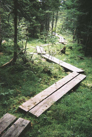
Hurlbert Swamp, meandering bog bridges
50 Hikes
North of the
White Mountains
New Hampshires Great North Woods
to the Canadian Border
KIM ROBERT NILSEN

AN INVITATION TO THE READER
Over time trails can be rerouted and signs and landmarks altered. If you find that changes have occurred on the routes described in this book, please let us know so that corrections may be made in future editions. The author and publisher also welcome other comments and suggestions. Address all correspondence to:
Editor, 50 Hikes Series
The Countryman Press
P.O. Box 748
Woodstock, VT 05091
Copyright 2012 by Kim Robert Nilsen
First Edition
All rights reserved. No part of this book may be reproduced in any form or by any electronic or mechanical means including information storage and retrieval systems without permission in writing from the publisher, except by a reviewer, who may quote brief passages.
50 Hikes North of the White Mountains
978-0-88150-972-4
Maps by Erin Greb Cartography, The Countryman Press
Book design by Glenn Suokko
Text composition by Eugenie S. Delaney
Interior photographs by the author unless otherwise noted
Published by The Countryman Press, P.O. Box 748, Woodstock, VT 05091 Distributed by W. W. Norton & Company, Inc., 500 Fifth Avenue, New York, NY 10110
Printed in the United States of America
10 9 8 7 6 5 4 3 2 1
My daughters, Shyloah and Willow, and my granddaughter, Sage, like
to hike as much as I do. This guidebook is dedicated to them. May
they have long and happy years tramping this grand green earth.
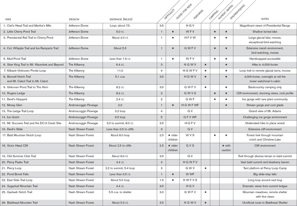
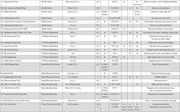
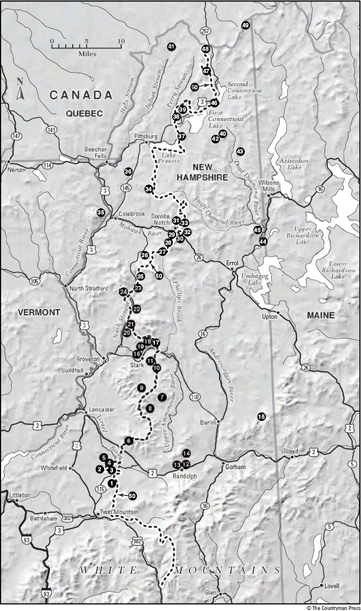
50 Hikes at a Glance
Contents
Acknowledgments
In the early 1970s, a New Hampshire conservation officer by the name of Arthur Muise walked into the Lancaster newspaper office where I was holding down my first real job. Arthur pulled the pipe out of his teeth and began to spin yarns about the backcountry of the Granite States largest and most remote county: Coos County. His stories were so compelling, I had to run off and go visit those places he was waxing so eloquently about. So in a very real sense, this guidebook has its origins in Arthurs words.
I must thank Lainie Castine, Yvan Guay, Chad Pepau, and Tracy Rexford, people who have helped me build a big web of trails in the Great North Woods where no trails existed. Their sweat and effort is evident throughout this tome.
I have to give credit to the State of New Hampshires Trail Bureau, Division of Forests and Lands, and the Fish and Game Department for considerable support, for having faith in the idea that there could be within the logging lands in the Granite States northernmost terrain multiple-use trails that could embrace hikers on foot. The timberland owners, too, went through a seismic shift in policy and philosophy over the four decades I spent moving about in the distant places. Exclusionary policies toward hiking and overnight camping dissipated when it became clear that multiple uses of forests benefited all parties greatly and actually helped keep vast tracts of land open and productive. So a great deal of credit must be bestowed on the timberland owners, for without those grand tracts of land to tramp on, there would be no trails, certainly no new trails, and no need for this guidebook.
Other players gave me a hand up in this process. John Lane, owner of an old labor camp in the Nash Stream Forest, made his camp available free of charge for years to me and trail builders, so we could carry on our work. Will Staats, a state biologist working out of the Lancaster state offices, was instrumental in paving the way for new pathways in very remote country. David Dernbach of the former Trailmasters youth program helped improve lots of trails listed in this guide. And Luke OBrien of the NorthWoods Stewardship Center at E. Charleston, Vermont, has done Herculean work with Kingdom Corps crews on trails within northern Coos County.
Steve Barba, former managing partner of the Balsams Grand Resort Hotel in Dixville Notch, has always been a big booster of northern Coos County and its recreational potential. The Tillotson family, through their important regional development granting foundation, the Neil and Louise Tillotson Fund, supported considerable trail development in the region.
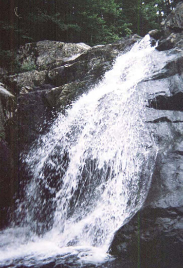
Garfield Falls close up
Introduction: Discovering New Hampshires Great Unknown
The mile-high peaks of New Hampshires White Mountain National Forest are Mecca for hikers in the eastern United States. For seasoned trekkers, Mounts Washington, Adams, Jefferson, Madison, Monroe, Eisenhower, Lafayette, and Lincoln are household names.
In some sense, though, these peaks and the dozens of 4,000-footers that pepper the forest are a love trap. Hikers lavish their attention on these lofty Appalachian Chain summits, at the expense of a whole host of other mountainous and backcountry features nearby.
Thats a shame, for to the north of the White Mountain National Forest stretches a vast timbered terrain bristling with summits and high ridgelines, and cradling waterfalls, canyons, elevated meadows, deep cold lakes, and drop-dead cliff faces. Just across NH (New Hampshire) 2 and NH 115 between the Granite State communities of Lancaster and Gorham, where the bulk of the White Mountain National Forest acreage comes to end, sprawls the sparsely populated realm of central and northern Coos (pronounced Co-ahss) County, a million acres of wild country and logging lands that few people know anything about and fewer venture into.
But there is an entire universe of tramper terrain to be explored, new trails to try, and historic old pathways to get acquainted with.
While Presidential Range hikers do move about within the political entity known as Coos County, the big summits rise near its southern tip. To the north, a central spine of lofty wooded peaks runs for 90 miles to the Canadian border and the province of Quebec. On either side of the county flow big rivers: New Englands largestthe Connecticut Riverto the west, and the Magalloway/Androscoggin river system to the east. Squeezed between these two mighty flows is a long band of upland just 30 miles wide that supports several 4,000-footers, some of the tallest ridgelines in the state outside the national forest, and mile after mile of remote and quiet trails that increasingly appeal to trekkers who no longer want to hike with the crowds.
Only 33,000 people reside in Coos County, and that number is actually declining and has been declining for nearly one hundred years. Half the population clusters around the 5-mile NH 16 as it threads through the communities of Berlin and Gorham. The remaining souls live in tiny villages strung out along NH 3 in the Connecticut River Valley. To this day, most local residents do not hike in the mountains, so chances are excellent you will have this million-acre big-forest environment to yourself.
Next page

