Best Hiking in Central Colorado
around Aspen, Marble, Leadville,
Buena Vista and Crested Butte
1st Edition, January 2017
Updated and Revised, March 2019
Copyright 2017, 2019 Diane Greer
All rights reserved.
ISBN: 978-0-9974780-3-7
All photos and original maps by the author
Cover photo: Maroon Bells, Buckskin Pass (Hike 1)
Your Safety is Your Responsibility
The author assumes no responsibility for the safety of users of this guide. Outdoor recreational activities involve a certain degree of risk and are by their very nature potentially hazardous. It is not within the scope of this guide to allow for disclosure of all potential hazards and risks involved in outdoor activities. All participants in such activities must assume the responsibility of their own actions and safety.
Furthermore, the author has done her best to make sure the information in this guide is as accurate and useful as possible. However, things can change, trails get rerouted, road conditions change, regulations are modified, etc. Hikers using the information in this guide should make allowances for the possibility that it may not be correct.
Even the best guide and maps cant replace good judgment and common sense. Be prepared and cautious. You will have a safer and more enjoyable trip.
Best Day Hikes in Central Colorado around the towns of around Aspen, Marble, Leadville, Buena Vista and Crested Butte
An opinionated guide to the best day hikes in one of Colorados best hiking areas, the Sawatch and Elk Mountains in Central Colorado.
If youre like me you love to hike and want to spend as much of your vacation and time off as possible on the trail. The challenge is weeding through all the online and hardcopy information to find the best hikes -- the trails that take you above timberline to beautiful mountain lakes nestled in dramatic cirques, to passes with see forever views and to glorious alpine meadows filled with wildflowers.
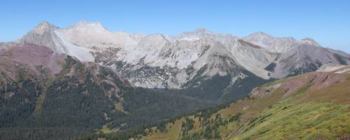
This opinionated guide does the work for you, choosing the best day hikes in one of Colorados best hiking areas, the Sawatch and Elk Mountains around the towns of . The Sawatch and Elk Mountain ranges offer the quintessential Rocky Mountain hiking experience with glacial valleys leading to vast alpine expanses sprinkled with glistening lakes amid soaring peaks. Three national forests and six wilderness areas protect this amazing landscape. Over 200 peaks rise above 13,000-ft. with 20 of the summits topping 14,000-ft.
The hikes in this guide, best hiked between mid-July and mid-September, appeal to hikers who like to go high and hike between 2 and 12 miles a day. Trails gain between 900- to 3,500-ft in elevation. Many of the trails offer great intermediate turnaround points for those seeking shorter hikes. All are reached in less than an hour drive from five great base camps; .
The base camps, each with its own distinct character, are linked by scenic drives traversing beautiful river valleys and crossing the high passes.
- Aspen to Leadville: The Top of the Rockies Byway between Aspen and Leadville, follows the narrow and winding CO-82 southeast through breathtaking scenery over 12,096-ft. Independence Pass to Twin Lakes, where it turns left (north) onto US-24 to Leadville. Along the way the route passes two of Colorados tallest peaks, Mt Elbert (14,333-ft.) and Mt. Massive (14,421-ft.). Total Distance: 58.5 miles.
- Leadville to Buena Vista: To reach Buena Vista from Leadville, follow US-24 south for 34.5 miles on the Top of the Rockies Byway and Collegiate Peaks Byway. The scenic drive along the Collegiate Peaks Byway features wonderful views of the 14,000-ft. peaks of the Collegiate Peaks Wilderness rising above the valley floor to the west. Total Distance: 34-miles.
- Aspen to Marble and Crested Butte: From Aspen take CO-82 northwest through the scenic Roaring Fork Valley to Carbondale and turn left onto CO-133, which is the start of the West Elk Loop Byway. The route ascends the beautiful Crystal River Valley, passing County Road 3, the turnoff to Marble. Beyond the turnoff the route climbs over McClure Pass (8,755-ft.), travels by the Paonia Reservoir and turns left (east) on the Kebler Pass Road (aka Gunnison County Road 12). The Kebler Pass Road, a good gravel road passable by passenger cars, climbs through beautiful forest to its namesake pass at 10,007-ft. before descending to Crested Butte: Total Distance: 104-miles.
- Crested Butte to Buena Vista: From Crested Butte head south on CO-135 to Almont and turn left (east) onto CO-742 toward the Taylor Park Reservoir. Just past the Reservoir, turn right onto the Cottonwood Pass Road (CO-209 that turns into CO-306). The route climbs over Cottonwood Pass (12,126-ft.) to Buena Vista, along the way enjoying great views of Taylor Park and the Collegiate Peaks. (Part of the Cottonwood Pass Road is a good gravel road passable by passenger cars.) Total Distance: 75.5-miles.
is a much smaller town with limited services.
The first section of this guide describes the towns, identifying local services, highlighting nearby attractions and suggesting activities for non-hiking/rainy days. The second section offers detailed trail descriptions with photos, maps, driving directions and elevation profiles of the recommended hikes.
Extensive photo galleries and interactive maps with GPS tracks of the hikes are available on a companion website www.hikingwalking.com.
I love feedback and would like to hear your opinion on how to improve the guide and the website. Obviously the selection of the best hikes is subjective, based on my personal opinion. Send an (bootjockey@hikingwalking.com) or post a comment on the website about the pros and cons of a particular hike or if you believe other hikes should be included in the best of list.
About the Ratings
All the hikes in this guide are recommended. That being said I want to make it easier for hikers to differentiate between trails. As such, hikes within a region are rated in relation to other hikes in the area. That does not mean that a hike rated as three stars is not worth doing. It just means if you only have a few days in a given area you might want to consider tackling the higher rated hikes first.
Abbreviations
RT Round-Trip, NF National Forest
Hiking Tips
Staying healthy and safe in the backcountry.
Hiking in the backcountry is a wonderful experience but can also be hazardous if you are not properly prepared. Here are some tips to help you to stay healthy and safe. For more backcountry hiking safety information check out the Hiking Safety tips from the American Hiking Society.
Trip Preparation
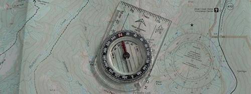
Your trip will be more enjoyable and safer if you take the time to plan it at home. Use forest recreation maps, topographic maps and trail guides to create an itinerary, calculate mileage and elevation gains, understand the terrain and learn about any potential hazards.
Take someone with you. Traveling with at least one hiking companion adds to your safety margin.
Before leaving home always leave your itinerary with a relative or friend. Write a full account of who is going, where you are going and when you will be back. For overnight trips include where you plan to stay each night.
Check current conditions posted on the forest service website to find out if there are any know hazards such as slippery roads, high fire danger and flash flood warnings. If possible, stop by the nearest Ranger Station before your trip to get the latest information.


