Don J. Scarmuzzi - Telluride Trails: Hiking Passes, Loops, and Summits of Southwest Colorado
Here you can read online Don J. Scarmuzzi - Telluride Trails: Hiking Passes, Loops, and Summits of Southwest Colorado full text of the book (entire story) in english for free. Download pdf and epub, get meaning, cover and reviews about this ebook. year: 2013, publisher: West Margin Press, genre: Home and family. Description of the work, (preface) as well as reviews are available. Best literature library LitArk.com created for fans of good reading and offers a wide selection of genres:
Romance novel
Science fiction
Adventure
Detective
Science
History
Home and family
Prose
Art
Politics
Computer
Non-fiction
Religion
Business
Children
Humor
Choose a favorite category and find really read worthwhile books. Enjoy immersion in the world of imagination, feel the emotions of the characters or learn something new for yourself, make an fascinating discovery.

- Book:Telluride Trails: Hiking Passes, Loops, and Summits of Southwest Colorado
- Author:
- Publisher:West Margin Press
- Genre:
- Year:2013
- Rating:3 / 5
- Favourites:Add to favourites
- Your mark:
Telluride Trails: Hiking Passes, Loops, and Summits of Southwest Colorado: summary, description and annotation
We offer to read an annotation, description, summary or preface (depends on what the author of the book "Telluride Trails: Hiking Passes, Loops, and Summits of Southwest Colorado" wrote himself). If you haven't found the necessary information about the book — write in the comments, we will try to find it.
Don J. Scarmuzzi: author's other books
Who wrote Telluride Trails: Hiking Passes, Loops, and Summits of Southwest Colorado? Find out the surname, the name of the author of the book and a list of all author's works by series.
Telluride Trails: Hiking Passes, Loops, and Summits of Southwest Colorado — read online for free the complete book (whole text) full work
Below is the text of the book, divided by pages. System saving the place of the last page read, allows you to conveniently read the book "Telluride Trails: Hiking Passes, Loops, and Summits of Southwest Colorado" online for free, without having to search again every time where you left off. Put a bookmark, and you can go to the page where you finished reading at any time.
Font size:
Interval:
Bookmark:
Telluride Trails
Hiking Passes, Loops, and
Summits of Southwest Colorado
Covering most of the trails and
more than seventy-five summits near
Telluride in Southwest Colorado
Don J. Scarmuzzi

P R U E T T
THE PRUETT SERIES
Text and photographs 2013 by Don Scarmuzzi
All rights reserved. No part of this book may be reproduced, stored in a
retrieval system, or transmitted in any form or by any means, electronic,
mechanical, photocopying, recording, or otherwise, without written permission
from the publisher.
No warranty of accuracy or reliability is given related to the contents of
this book. All recommendations and information provided in this book are
made without guarantee on the part of the author or Graphic Arts Books.
The author and Graphic Arts Book disclaim any responsibility or liability in
connection with the use of this information.
Library of Congress Cataloging-in-Publication Data
Scarmuzzi, Don, author.
Telluride trails : hiking passes, loops, and summits of southwest Colorado :
covering most of the trails and more than seventy-five summits near Telluride
in southwest Colorado / Don Scarmuzzi.
pages cm. (The Pruett series)
Includes index.
ISBN 978-0-87108-971-7 (pbk.)
ISBN 978-0-87108-997-7 (e-book)
ISBN 978-0-87108-304-3 (hardbound)
1. Hiking Colorado Telluride Region Guidebooks. 2. Telluride
Region (Colorado) Guidebooks. I. Title.
GV199.42.C62T457 2013
796.5109788 dc23
2013022978
Designer: Vicki Knapton
Editor: Mindy Fitch
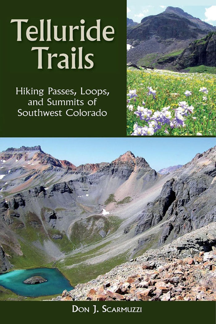
Cover photo top right: Choking on wildflowers in Waterfall Canyon above
Ophir! Cover bottom: Pilot Knob, V-4, US Grant, and Island Lake from V-2
WestWinds Press
An imprint of

P.O. Box 56118
Portland, OR 97238-6118
(503) 254-5591
www.graphicartsbooks.com
Dedicated to the memory of Andy Sawyer, who took so many to great heights in mind, body, and spirit.
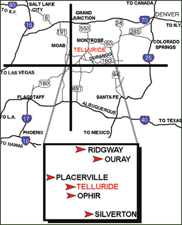
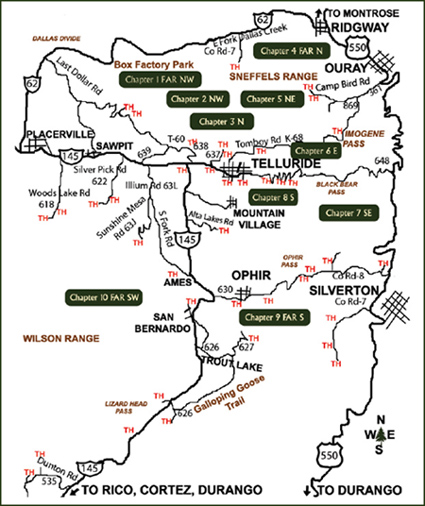
Four distinct waterfalls are visible or nearly visible from the town of Telluride, Colorado, and many more can be found near the high basins and peaks surrounding this spectacular region of the Rocky Mountains. Dozens of the 110 hikes presented in this guide begin right from downtown Telluride, while others branch out from the mountain roads nearby, and some are located closer to Durango, Silverton, Ouray, Ridgway, Montrose, Ophir, Rico, Dolores, and Cortez.
Each hike begins with essential information such as elevation, distance, duration, and difficulty level. Elevation information includes not only the highest point (or points) of a hike but also the maximum vertical gains you will experience along the trail. Difficulty levels range from easiest (no elevation change) to moderate (short hike, easy grades), strenuous (typical to moderate hike, hills), very challenging (longer hike, steeper, with varying mountain conditions), and expert-only (very steep, often with exposed ridge walking and loose scree, requiring climbing-type moves). Most of the hikes fall somewhere in the middle, and all hikes but those rated very challenging or expert-only will be achievable for most people. Climbing ropes, pitons, or anchor bolts are not mandatory to complete any of the hikes listed here, though that may not be the case for everyonesee difficulty levels for each hike for recommendations. You certainly wont hear me use terms like underclings, stemming, laybacks, jams, or evangelical hammerlocks!
More than half of these trails can be hiked as a loop, and I provide alternate routes (Alt) and optional paths (Opt) wherever possible. The routes described for each hike may be well-worn trails, complete bushwhacks and scrambles, or anything in between. There is something here for practically everyone, whether you would rather simply cut to the chase, as it were, and get on with something more challenging, or prefer a more leisurely stroll through the aspens, evergreens, and basins without going to a summit or having to use any climbing-type moves. Youll find detailed instructions to locating seventy-five peaks and other high points, including many mountain passes and vistas.
Many trails can be traveled by mountain bike, and others may require some four-wheel driving (4WD). Youll find  or 4WD at the beginning of each chapter. (I have even included one routeGalloping Goose Trail to Lizard that requires a bike. It is such a beautiful and classic ride, I just couldnt help myself.)
I try to keep hiking lingo simple. Trailhead is abbreviated as TH. A switchback is a spot in a trail that zigzags sharply, whether once or fifty times. A shoulder is a rise or small ridge. Exposure refers to the level of risk of falling where a fall would be fatal. A trail section described as airy is exposed to some degree, with drop-offs. Exercise extreme caution in such areas.
Aspen line is around 11,800 feet, and tree line is around 12,200 feet in this region. I usually find that the first 20 to 30 minutes of practically any hike can be the toughest until I get into a groove with my breathing and walking. High altitude affects everybody differently, so if you feel dehydrated, headachy, or nauseous, move to a lower altitude. (Some people might even experience altitude sickness while still in Telluride, at 8745 feet.) Mountain hazards (rapidly changing weather, rock slides) and the unexpected almost always come into play, so dont count on apps from your phone to save you in the wilderness!
With so much wildlife around, dont forget to watch out for the blood burglars, including ticks and to a lesser degree mosquitoes. Luckily you probably will not run across the tiny deer ticks that cause Lyme disease, but a larger species, the Rocky Mountain wood tick, is plentiful from spring through June and should be avoided. These ticks thrive in low grass and brush in the high countrya tick check, or self-examination, during and after spring hikes is a good idea. If a tick has latched on or is slightly embedded in your skin, pull it straight out with tweezers or hold a lighter flame close until it falls away. However, tick warning aside, you would be worse off if you forgot your sunscreen or enough water on a warm bluebird day.
All right, enough talk. Its go time! You can hike the mountains in Southwest Colorado year-round if you know what you are doing and have the proper gear, but the ideal time to hike or mountain bike is late June through mid-October. All you need is a nice pair of hiking shoes, a backpack with plenty of supplies, water, phone, camera, GPS, MP3 player, pedometer, more electric junk you never used to need but now cant get by withoutand the day to unfold before your very eyes, just one foot in front of the other.
Four Corners
Telluride
Font size:
Interval:
Bookmark:
Similar books «Telluride Trails: Hiking Passes, Loops, and Summits of Southwest Colorado»
Look at similar books to Telluride Trails: Hiking Passes, Loops, and Summits of Southwest Colorado. We have selected literature similar in name and meaning in the hope of providing readers with more options to find new, interesting, not yet read works.
Discussion, reviews of the book Telluride Trails: Hiking Passes, Loops, and Summits of Southwest Colorado and just readers' own opinions. Leave your comments, write what you think about the work, its meaning or the main characters. Specify what exactly you liked and what you didn't like, and why you think so.