CONTENTS
Guide
A number of land managers provided background information and reviews for this book. Particular thanks go out to Andy Steele, Dan Matthews, Mike Uncapher, and Jon Morrissey. Shelly Grail and Katy Nelson provided helpful information during the revision of this book. Thanks to Tom Martin and Randy Hancock for information on fishing in these wilderness areas. Much of the background research was performed at the Aspen Historical Society and the Aspen Public Library, both in their own way excellent facilities. Particular thanks to Allen Kane for providing hard-to-find interpretive information about historical sites. We owe a debt of gratitude to all those who have saved and collected historical information over the years, that it might be available for future readers to enjoy. Map research was performed at the Montana State University and University of Wyoming geology departments.
PIKE AND SAN ISABEL
NATIONAL FORESTS
Forest Supervisors Office
2840 Kachina Drive
Pueblo, CO 81008
(719) 553-1400
www.fs.usda.gov/psicc
Leadville Ranger District
810 Front Street
Leadville, CO 80461
(719) 486-0749
Salida Ranger District
5575 Cleora Road
Salida, CO 81201
(719) 539-3591
WHITE RIVER NATIONAL FOREST
Forest Supervisors Office
PO Box 948
900 Grand Avenue
Glenwood Springs, CO 81602
(970) 945-2521
www.fs.usda.gov/whiteriver
Aspen Ranger District (open seasonally)
806 West Hallam Street
Aspen, CO 81611
(970) 925-3445
Aspen-Sopris Ranger District
620 Main Street
Carbondale, CO 81623
(970) 963-2266
GRAND MESA UNCOMPAHGRE
AND GUNNISON (GMUG)
NATIONAL FORESTS
Forest Supervisors Office
2250 Highway 50
Delta, CO 81416
(970) 874-6600
www.fs.usda.gov/gmug
Gunnison Ranger District
216 North Colorado Street
Gunnison, CO 81230
(970) 641-0471
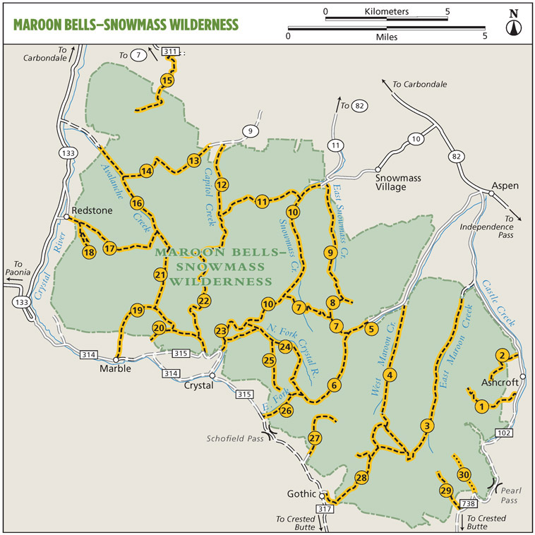
The Maroon BellsSnowmass Wilderness is world-famous for its spectacular mountains, glittering lakes, and flower-splashed alpine meadows. Great herds of elk inhabit the western end of the wilderness, and smaller creatures such as marmots, pikas, and ptarmigan can be found in the high country. The boom of tourism in nearby Aspen has led to a flood of hikers and tourists into these mountains during summertime. The most popular areas are the Maroon Lake/West Maroon Creek area, Snowmass Creek, and Conundrum Creek. Only the far southeastern corner of the wilderness, south of Pearl Pass, receives consistently light use. There are few places in this wilderness that are out of the range of day hikers. At the eastern end of the wilderness, the peaks are made up of the legendary crimson bedrock of the Maroon formation. Red sandstone dominates these strata, which were formed from sand, clay, and gravel washed down from the ancestral Rockies during a period when bony fishes were just evolving in Permian seas. In places, the Maroon formation was later infused with veins of hot magma, which superheated the shales and sandstones into harder metamorphic rocks. Farther west, the high peaks are composed of much harder granite. Snowmass Mountain, Capitol Peak, and Mount Sopris share these igneous origins.
This wilderness has a rich and colorful mining history. The year 1879 marked the beginning of the silver boom in these mountains, and soon mining camps were established at Ashcroft, Gothic, Schofield, and Crystal. Ore from the Roaring Fork valley was initially freighted over the high passes to smelters in Leadville and Gothic. By 1887 the railroads had arrived in Aspen, and the new boomtown took over much of the ore traffic. Mines both small and large flourished until the early 1890s, when the silver market crashed and a mass exodus left most of the mining town vacant. Modern visitors will find ruins of lone prospectors cabins, abandoned mine shafts, and even remnants of old ghost towns in the remote valleys of the wilderness.
Visitors can get information at the ranger station in Carbondale (seasonally at the Aspen Ranger Station) and at the applicable US Forest Service websites. For visitors approaching from the south, the nearest reliable source of Forest Service information is at the ranger station in Gunnison. Aspen, Carbondale, Crested Butte, and Gunnison offer most services required by backpackers. CO 82 and 330 offer easy access to the north and west sides of the range, respectively. The east and south sides are a bit more problematic: Lead King Basin Road, near Marble, is passable only when dry and even then is restricted to four-wheel-drive vehicles. The Pearl Pass and upper Crystal River routes are very rugged and strike fear into the hearts of even experienced four-wheel enthusiasts.
WHY GO?
A day hike to Cathedral Lake or Electric Pass
THE RUNDOWN
Distance: 5.0 miles out and back (2.5 miles one-way) (Cathedral Lake); 9.4 miles out and back (4.7 miles one-way) (Electric Pass)
Difficulty: Moderately strenuous
Best season: Mid-June to mid-October (Cathedral Lake); early July to mid-October (Electric Pass)
Visitation: Very heavy
Elevation gain: 2,000 feet to Cathedral Lake; 3,600 feet to Electric Pass
Maximum elevation: 11,900 feet (Cathedral Lake); 13,500 feet (Electric Pass)
Map:USGS Hayden Peak (location approximate)
Trail contact: Aspen-Sopris Ranger District, White River National Forest, 620 Main St., Carbondale 81623; (970) 963-2266; fs.usda.gov/whiteriver
FINDING THE TRAILHEAD
 Follow CO 82 out the west end of Aspen to the roundabout and turn left (south) on Castle Creek Road (FR 102). Follow it for 12.1 miles, then turn right at the second sign marked Trailhead. Follow this dirt road for 0.6 mile to the trailhead.
THE HIKE
The upper basin of Pine Creek is guarded by the sawtooth crags of Cathedral Peak, and nestled in its upper basin is an aquamarine gem known as Cathedral Lake. This trail offers a popular day hike to the lake, and adventurous hikers can continue up to the 13,500-foot divide of Electric Pass for some of the best mountain panoramas in the wilderness. Be sure to plan your trip so you can descend from the pass before noon and avoid the potential for thunderstorms. The trail that once descended from Electric Pass to Cataract Creek and on to the Conundrum Creek valley has been abandoned, and the upper reaches are now considered impassable.
The trail begins by running southward through the aspens, and soon it begins the steady climb toward the mouth of the Pine Creek valley. As the trail turns the corner, there is a fine overlook of Castle Creek, with Taylor and Star Peaks rising beyond it. The path now turns west, climbing steadily as the aspen woodland begins to thin out. A grove of timber pines shades the first overlook of Pine Creeks granite gorge. Soon the trees fall away, and open slopes yield views of the sedimentary peaks that flank the steep valley. The pitch of the trail increases to a calf-burning climb as you approach a series of waterfalls, and now Malamute Peak can be seen ahead.
At the top of the grade, the path levels off as it enters the lower basin of Pine Creek. A broad panorama of crags and pinnacles surrounds this pretty bowl. Soon the trail resumes its steady climb along the north wall of the basin. Ultimately a talus slope leads to the base of a steep couloir, where a series of tight switchbacks leads upward. At the top of the grade is a junction; Cathedral Lake lies to the left, while to the right is the trail to Electric Pass.



 Follow CO 82 out the west end of Aspen to the roundabout and turn left (south) on Castle Creek Road (FR 102). Follow it for 12.1 miles, then turn right at the second sign marked Trailhead. Follow this dirt road for 0.6 mile to the trailhead.