Erik Molvar has spent decades exploring the wildlands of the West. He has hiked over 10,000 miles of trails, from the Arctic Ocean to the Mexican border. Erik has a masters degree in wildlife management from the University of Alaska Fairbanks, where he performed groundbreaking research on moose in Denali National Park. He currently is the executive director of Western Watersheds Project, a west-wide leader in protecting public lands and wildlife.
Also by the author:
Hiking the North Cascades
Hiking Olympic National Park
Best Easy Day Hikes: Olympics
Hiking Glacier and Waterton Lakes National Parks
Best Easy Day Hikes: Glacier and Waterton Lakes
Hiking Montanas Bob Marshall Wilderness
Hiking Arizonas Cactus Country
Hiking Zion and Bryce Canyon National Parks
Best Easy Day Hikes: Zion and Bryce
Alaska on Foot: Wilderness Techniques for the Far North
Scenic Driving Alaska and the Yukon
Hiking Wyomings Cloud Peak Wilderness
Wild Wyoming
Hiking Colorados Maroon BellsSnowmass Wilderness
Thanks to Kelly Bush, Hugh Dougher, Marshall Plumer, and other rangers of North Cascades National Park and Okanogan National Forest for providing information and reviewing this book. Rosemary Siefrit and Todd Johnson provided information for the revisions. The introductory material is largely the work of Bill Schneider. Special thanks to my former wife, Melanie, for providing good company during the field research.
Type of hike: Out-and-back.
Distance: 7.6 miles.
Time required: 4 to 7 hours.
Elevation change: 780-foot gain.
Best season: Mid-June to mid-October.
Maps: USGS Bacon Peak; Green Trails Lake Shannon.
Jurisdiction: Noisy-Diobsud Wilderness (Mount BakerSnoqualmie National Forest).
Finding the trailhead: Follow Washington Highway 20 west from Concrete for 5 miles to the Baker River Highway (Forest Road 11). Follow this road north for 14 miles, then turn right at signs for Baker Dam. Drive across the dam and then turn north (left) onto Forest Road 1107, a logging road passable to passenger cars. Follow this road upward for 9.2 miles to a junction with Forest Road 1107-022. Turn left onto this spur and follow it for 1.2 miles to the trailhead.
The Hike
A network of short trails climbs to the timberline at the edge of the Noisy-Diobsud Wilderness, visiting alpine lakes and an old lookout site. Wildflower displays are impressive here, and black bears are commonly sighted. Watson Lakes makes the easiest and most scenic destination, while more ambitious hikers can also opt to visit Anderson Lakes and/or Anderson Butte for a more challenging trip.
The trail begins by ascending gradually across steep slopes robed in an old-growth coastal forest. Western hemlock is the dominant conifer here, but silver fir is also present. Observe the open nature of the forest and the rich mixture of tree sizes: This complexity provides a multitude of ecological niches for forest animals, accounting for the importance of old growth to forest ecosystems.
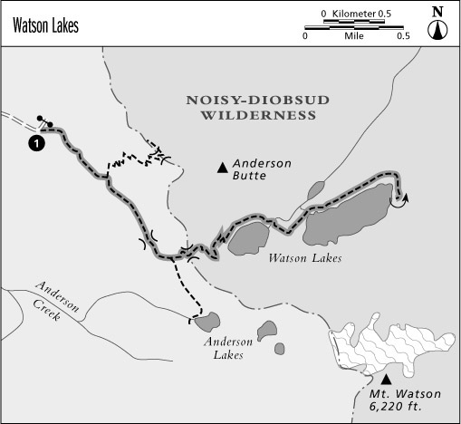
After crossing sinuous finger ridges and low saddles, the path emerges unexpectedly into a luxuriant meadow of heather and sedges. The Anderson Butte Trail splits away at the bottom of the meadow, while the main path ascends through the opening to reveal striking views of Mounts Baker and Shuksan to the northwest. Meadows such as these occur in pockets that fill with deep snow, making for a short growing season that effectively excludes most conifers. A few clumps of mountain hemlock grow from the hillocks where the snow melts sooner. Wildlife enthusiasts can glass for pikas in the talus of the lower slopes of Anderson Butte. At the upper edge of the meadow, the trail crosses a pass and enters heavy timber once more. A faint spur path runs to an outcrop that faces southwest for views across Baker Lake.
The main trail descends through the trees to reach a boggy meadow, where the path to Anderson Lakes splits away to the right. The Watson Lakes Trail now climbs vigorously to reach a low notch, then descends into the Noisy-Diobsud Wilderness. Just beyond the boundary, open slopes face eastward across the Watson Lakes for views of majestic Bacon Peak. Hagan Mountain is visible farther to the north. The path now descends sharply to reach camping spots in the heavy timber on the north shore of the western lake.
Our route continues around the lakeshore and crosses the logs at its outlet to reach camping spots amid the heather-sedge parks above the second lake (campers must pitch their tents in designated spots). This lake is the larger of the two, with rocky peninsulas that jut out into the water. The track becomes more primitive as it crosses the log boom at the outlet of the lake and climbs and falls sharply across the hummocky heather. There are excellent views of Martin Peak along the way, and Anderson Butte is unveiled in its rocky majesty from the trails end on the eastern shore. Turn around here and retrace the trail to complete the hike.
Miles and Directions
- 0.0 Watson Lakes Trailhead
- 0.8 Junction with Anderson Butte Trail (0.7 mile, moderately strenuous). Stay right for Watson Lakes.
- 1.6 Junction with Anderson Lakes Trail (0.9 mile, moderate). Stay left for Watson Lakes.
- 1.9 Trail crosses pass and enters Noisy-Diobsud Wilderness.
- 2.5 Camping area beside western Watson Lake. Trail follows lakeshore.
- 2.9 Trail reaches foot of lake.
- 3.1 Foot of eastern Watson Lake. Trail follows lakeshore.
- 3.8 Head of eastern Watson Lake. Turn around.
- 7.6 Arrive back at Watson Lakes Trailhead.
Type of hike: Out-and-back.
Distance: 4.0 miles.
Time required: All day.
Elevation change: 1,309 foot gain.
Best season: June through September.
Topo Map: Baker Pass.
Jurisdiction: Mount BakerSnoqualmie National Forest.
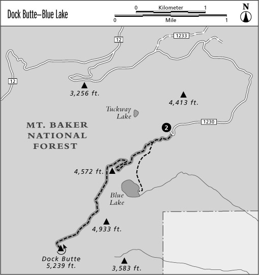
Finding the trailhead: Follow Washington Highway 20 west from Concrete for 5 miles to the Baker River Highway (Forest Road 11) at mile 82.5. Follow this paved road north for 8 miles, then turn left on Forest Road 12 just after entering the national forest. Follow this broad gravel road for 7 miles, then turn left on Forest Road 1230. After 4 miles of narrow, winding road, you will reach the trailhead at its end.
The Hike
This short but vigorous day hike climbs to the summit of a small knob that commands views of the Skagit Valley and Mount Baker. A spur trail down to Blue Lake makes an easier destination and is discussed at the end of this section.
The hike begins in subalpine parklands, where mountain hemlocks rise in clusters between heather-filled glades. These glades indicate locations where persistent snowdrifts linger into early summer, resulting in a growing season that is too brief to support the establishment of trees. The path runs west and then south across the mountainsides, navigating between the summits of wooded knobs, and soon reaches a pass where the trail splits. To the left is the trail to Blue Lake (see below), while the path to the right begins the hearty climb to the top of Dock Butte.


