RIDING THE
DRAGONS
SPINE
BEIT BRIDGE TO CAPE TOWN
SAS ULTIMATE MTB TRAIL
David Bristow & Steve Thomas
First published in 2012 by Struik Travel & Heritage
(an imprint of Random House Struik (Pty) Ltd)
Company Reg. No. 1966/003153/07
Wembley Square, First Floor, Solan Road, Gardens,
Cape Town 8001, South Africa
PO Box 1144, Cape Town 8000, South Africa
Copyright in published edition: Random House Struik 2012
Copyright in text: David Bristow 2012
Copyright in photographs: Jacques Marais (cover); Steve Thomas (title page and where
indicated); David Bristow 2012
Copyright in maps and illustrations: Steve Thomas and Ricky Thomas 2012
Publisher: Claudia Dos Santos
Managing editor: Roelien Theron
Editorial assistant: Alana Bolligelo
Editor: Marille Renssen
Designer: Catherine Coetzer
Cartographers: Steve Thomas and Ricky Thomas
Proofreader: Lesley Hay-Whitton
ISBN 978 1 43170 030 1 (Print)
ISBN 978 1 92054 529 1 (ePub)
ISBN 978 1 92054 530 7 (PDF)
All rights reserved. No part of this publication may be reproduced, stored in a retrieval system or transmitted, in any form or by any means, electronic, mechanical, photocopying, recording or otherwise, without the prior written permission of the publishers and the copyright holder(s).
While every effort has been made to ensure the information in this book is as accurate as possible at the time of going to print, the authors and publishers can accept no responsibility for any consequences, loss, injury, damage or inconvenience sustained by any person using the information contained herein. Please email any comments or updates to:
The route maps in this guidebook are supplemented by GPS tracks, which are available as free downloads from www.dragontrax.co.za
Get monthly updates and news by subscribing to our newsletter at www.randomstruik.co.za
ABOUT THIS GUIDE
The Spine of the Dragon trail and this guide to riding it are not an exact science: the riding was designed to be fun, and the route was designed to be flexible. The book provides just about everything you need to do the trail: route descriptions and distances, trail gradings, maps, contact information and even our own home-baked philosophies about life and riding. In between all this youll find bits of history, geography, philosophy and other nonsense that came into our heads as we were riding.
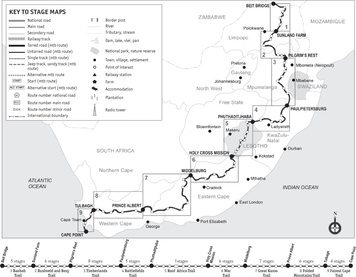
We have divided the trail and the book into nine discrete sections, each one of which could be ridden as a shorter mountain bike touring holiday. Each section is further broken down into stages, amounting to a total of 58 day stages, each equivalent to a days riding. Some people will want to try to ride the whole thing in one huge bite, or to knock off entire sections one after the other over time. Others might want to spend only a couple of days on the trail, in which case theyll have a multitude of options to choose from.
Each stage is described in detail. It is introduced by a brief summary of what you can expect along the route and is followed by an overview of the experience, offering insights into the days journey. It might not be exactly as you experience it, but then that is the beauty of it: it will be unique to each person as he or she goes, or else why bother?
The overview is followed by a full description of the days route. Mostly the routes are straightforward following pretty much the same way most people would go if they had to connect the dots from one end of the country to the other. However, in some cases things became far from straightforward, such as when we had to get over or around mountain ranges, or swollen rivers, or when the distance between places to stay was too great to be done by the average cyclist in one day. Where possible we have given alternative routes on the maps as well as in the narrative, but not always; this is because we cannot anticipate exactly what you want to do, and wed like to give you some leeway to make your own adventure. Like when the weather bowls you a googly and you have to make plan B.
To remove some of your stress, we have included recommendations about where to stay at the end of each days ride as well as the contact details for the various establishments. We have asked each place we used, with the exception of community facilities or small local establishments, to give Spine riders a special rate, so do ask for it.
The maps youll find in this guide are pretty good approximations of the route as you ride it, but of course they are not detail-perfect. A person with a really good sense of direction would almost certainly be able to complete the trail using just the route descriptions and the maps. After all, we did not have any route map to follow when we made up the trail.
). They also show the most pertinent towns, mountains, rivers and points of interest along each route to help you interpret the landscape.
Only where relevant, alternative routes suggested in the book are indicated on the maps. When choosing which route to take, you should consider the experience, fitness and abilities of the members of your group. Some people will be able to ride further than us, others less.
For people with a less well-developed sense of direction, we have posted all the GPS tracks on our Dragon Trax website (www.dragontrax.co.za). However, you would have to be a veritable Henry the Navigator to use only the GPS tracks without cross-consulting this guide, which fills in the detail along an otherwise featureless map on a small electronic device. Together, though, they make fine bicycling music.
BRISTOW-THOMAS GRADING SYSTEM
Since the international mountain biking grading system of green, red and black routes (taken from skiing) hardly applies to bicycle or mountain bike touring routes, we developed our own. We call it the BristowThomas system, and it looks like this:
Short, easy/moderate typically 3050km (sometimes less), no very hard climbs or technical sections
Short, hard similar distance but with physically hard and/or technical sections
Medium, easy/moderate typically 5070km, no severe sections
Medium, hard similar distance but with hard ascents and/or technical sections
Long, easy/moderate more than 70km, no sustained or severe ascents or technical sections
Long, hard similar distance but with strenuous riding and/or technical sections
All routes in this guidebook have been ranked using this system.
OVERVIEW: SPINE OF THE DRAGON TRAIL
 1 BAOBAB TRAIL
 (5 stages)
Summer or winter, this section (which takes you through the far north) is as hot as hot gets in South Africa, which is why you should ride this trail in the milder seasons. If you are planning on doing the entire Spine of the Dragon route in one go, you should time riding the Baobab section in spring or autumn, provided that you take into account when that will get you through Lesotho and the Cape Folded Mountains, where the cold and rain are formidable factors. The biggest attraction of the area is how rural and African it is, so make a point of stopping often and engaging the locals.




 1 BAOBAB TRAIL (5 stages)