About the Author
Steve Davison is a freelance writer and photographer who has lived in Berkshire for over 25 years. He has written several guidebooks as well as articles for a number of outdoor magazines and national and local newspapers, specialising in hill-walking and UK and European travel, and counts nature, geology and the countryside among his particular interests. A keen hill-walker for many years, and a Mountain Leader, Steve has also worked as a part-time outdoor education instructor. He is also a member of the Outdoor Writers and Photographers Guild. Find out more about him at www.steve-davison.co.uk
Other Cicerone guides by the author
The Ridgeway National Trail
Walking in the New Forest
Walking in the Thames Valley
WALKING IN THE CHILTERNS
by Steve Davison
2 POLICE SQUARE, MILNTHORPE, CUMBRIA, LA7 7PY
www.cicerone.co.uk
Steve Davison 2014
First edition 2014
ISBN: 978 1 85284 700 5
Printed in China on behalf of Latitude Press Ltd.
A catalogue record for this book is available from the British Library.
All photographs are by the author unless otherwise stated.
 This product includes mapping data licensed from Ordnance Survey with the permission of the Controller of Her Majestys Stationery Office. Crown copyright 2014. All rights reserved. Licence number PU100012932.
Advice to Readers
While every effort is made by our authors to ensure the accuracy of guidebooks as they go to print, changes can occur during the lifetime of an edition. If we know of any, there will be an Updates tab on this books page on the Cicerone website (www.cicerone.co.uk), so please check before planning your trip. We also advise that you check information about such things as transport, accommodation and shops locally. Even rights of way can be altered over time. We are always grateful for information about any discrepancies between a guidebook and the facts on the ground, sent by email to info@cicerone.co.uk or by post to Cicerone, 2 Police Square, Milnthorpe LA7 7PY, United Kingdom.
Front cover: Typical Chiltern scenery on the way to Christmas Common (Walk 22)
CONTENTS

Leaving Great Chalk Wood to head through fields towards Goring-on-Thames (Walk 34)
INTRODUCTION

Looking north from Pitstone Hill (Walk 6) to Steps Hill (straight ahead) and Ivinghoe Beacon (left) visited on Walk 5
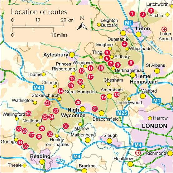
The Chilterns Area of Outstanding Natural Beauty (AONB) covers an area of 833km in south-east England, stretching north-east for 70km from the River Thames at the Goring Gap in Oxfordshire through Buckinghamshire and Bedfordshire to Hertfordshire. This chalk landscape is famed for its beech and oak woods (around one fifth of the area is covered by woodland) which give way to a more open chalk grassland along its northern reaches, such as the Ivinghoe Hills and Dunstable Downs. The Chilterns are definitely hilly but they dont rise to any great height: the highest point albeit a rather indistinct feature surrounded by dense woodland is Haddington Hill near Wendover at 267m. More prominent hills, with the advantage of panoramic views, include Coombe Hill near Wendover at 260m (Walk 12) and Beacon Hill near Ivinghoe at 249m (Walk 5).
The area of the AONB itself has a relatively low population around 100,000 but its boundary skirts around larger urban areas such as High Wycombe and Luton, meaning that a further half million people live within 3km. Good transport links also make the Chilterns easily accessible to people from London.
Yet peace and tranquillity are in abundance: listen to the birdsong in the ancient woodlands or the skylarks singing over the open grassland; be dazzled by the myriad flowers and butterflies; admire the gently rolling landscape that has inspired many over the centuries, from famed authors to artists and poets, including the WWI poet Rupert Brookes, who wrote of the countryside in his poem The Chilterns :
I shall desire and I shall find
The best of my desires;
The autumn road, the mellow wind
That soothes the darkening shires.
And laughter, and inn-fires.
Be inspired, and explore some of the 2000km of footpaths and bridleways that criss-cross the Chilterns.
Geology

Looking north along the crest of the Dunstable Downs to the summit above Pascomb Pit (Walk 4)
The geology of the Chilterns tells the story of the seas that once covered southern England and the sediments that were laid down at that time. It is perhaps easiest to think of the areas geological structure as a multi-layered cake.
The lowest, and oldest, layers of this cake in the Chilterns are formed from Gault Clay and Upper Greensand, laid down during the latter part of the Lower Cretaceous period (14599 million years ago). In the middle is a thick layer of Upper Cretaceous chalk, formed 9965 million years ago from incredible numbers of minute calcareous shells which are the remains of plankton, known as coccoliths, which lived in the shallow subtropical seas that once covered much of southern England.
Chalk is a highly porous rock with numerous microscopic pore spaces that can store huge amounts of water, thus it acts like a giant sponge or aquifer, soaking up most of the rainfall. Because of this, over most of the higher ground there is no surface water in the form of ponds or streams.
Associated mainly with the upper (white) layer of chalk are horizontal bands of irregular silica concretions, known as flints; these also occur in profusion in the jumbled deposits of weathered chalk, known as clay-with-flints. When struck, flint breaks with a shell-shaped fracture, leaving very sharp edges, and our Stone Age ancestors used flints to make a range of tools. Being a very hard-wearing rock, flint has been widely used as a building material both in its natural state and knapped to form a flatter surface. It is a characteristic of the area a great number of the regions churches and old cottages have flint walls.

St Marys Church, Hawridge a typical flint-built church (Walk 10)
Finally, at the top are the Tertiary (652.6 million year-old) deposits that include layers of clay. Historically this clay has been used to make bricks and tiles, such as at Nettlebed (Walk 29). It was during the Tertiary period that the European and African continental plates collided an event that formed the Alps. In southern England the effects were less dramatic, although the collision caused our sedimentary cake to ripple, with resultant changes to the landscape that remain in evidence today, including the formation of a prominent ridge with a steep north-facing scarp slope along the northern edge of the Chilterns with the wide, flat plain of the Vale of Aylesbury beyond. This rippled layer of chalk also forms the Berkshire Downs, the North Hampshire Downs, the North and South Downs and the Purbeck Hills in Dorset.





 This product includes mapping data licensed from Ordnance Survey with the permission of the Controller of Her Majestys Stationery Office. Crown copyright 2014. All rights reserved. Licence number PU100012932.