100 WALKS IN
WILTSHIRE

THE CROWOOD PRESS
First published in 2015 by
The Crowood Press Ltd
Ramsbury, Marlborough
Wiltshire SN8 2HR
www.crowood.com
This e-book first published in 2016
The Crowood Press 2015
All rights reserved. No part of this publication may be reproduced or transmitted in any form or by any means, electronic or mechanical, including photocopy, recording, or any information storage and retrieval system, without permission in writing from the publishers.
British Library Cataloguing-in-Publication Data
A catalogue record for this book is available from the British Library.
ISBN 978 1 78500 044 7
Mapping in this book is sourced from the following products: OS Explorer 118, 130, 131, 142, 143, 155, 156, 157, 158, 168, 169, 170
Crown copyright Ordnance Survey. Licence number 100038003
Every effort has been made to ensure the accuracy of this book. However, changes can occur during the lifetime of an edition. The Publishers cannot be held responsible for any errors or omissions or for the consequences of any reliance on the information given in this book, but should be very grateful if walkers could let us know of any inaccuracies by writing to use at the address above or via the website.
As with any outdoor activity, accidents and injury can occur. We strongly advise readers to check the local weather forecast before setting out and to take an OS map. The Publishers accept no responsibility for any injuries which may occur in relation to following the walk descriptions contained within this book.
Contents
How to Use this Book
The walks have been written in distance order, starting with the shortest at 2 miles and ending with the longest at 12 miles.
Readers should be aware that starting point postcodes have been supplied for satnav purposes and are not necessarily indicative of exact locations.
M APS
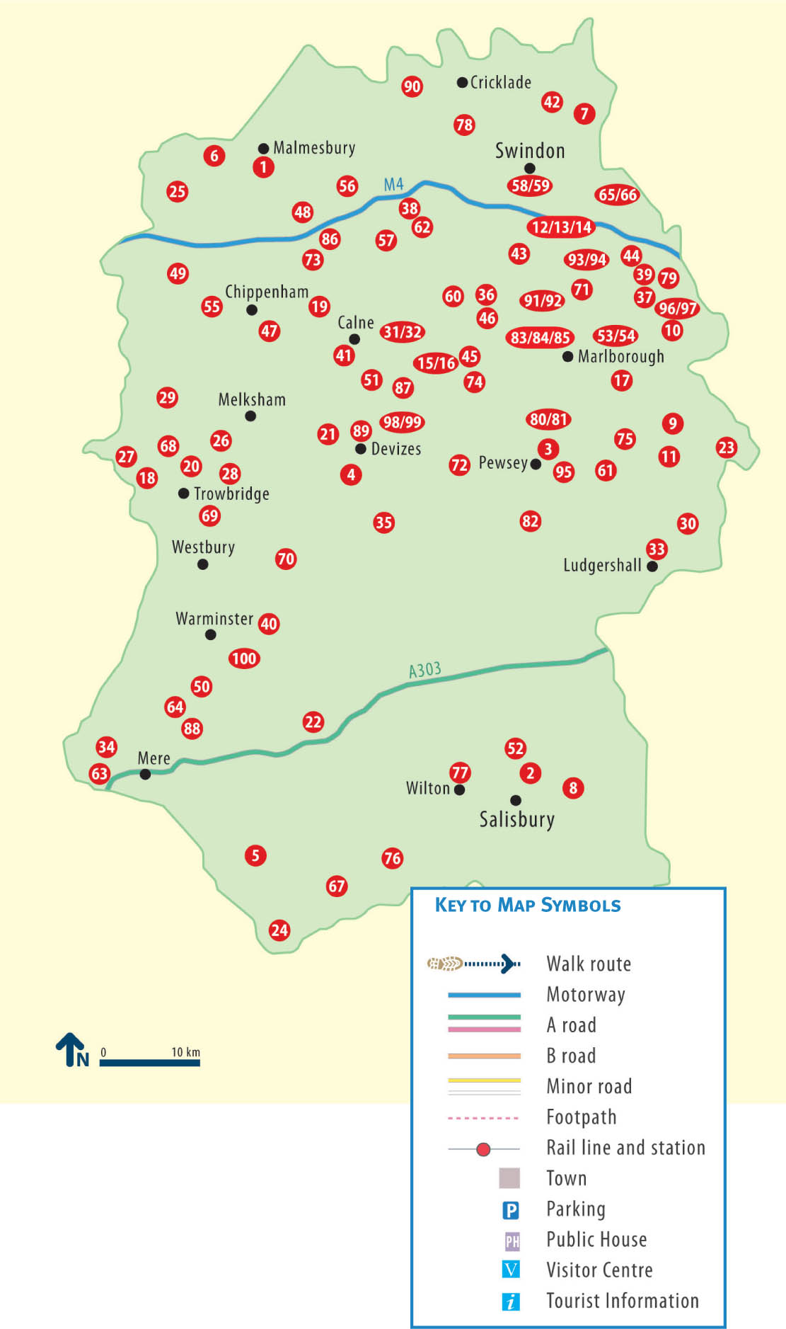
There are 86 maps covering the 100 walks. Some of the walks are extensions of existing routes and the information panel for these walks will tell you the distance of the short and long versions of the walk. For those not wishing to undertake the longer versions of these walks, the short-cuts are shown on the map in red.
The routes marked on the maps are punctuated by a series of numbered waypoints. These relate to the same numbers shown in the walk description.
Start Points
The start of each walk is given as a postcode and also a six-figure grid reference number prefixed by two letters (which indicates the relevant square on the National Grid). More information on grid references is found on Ordnance Survey maps.
Parking
Many of the car parks suggested are public, but for some walks you will have to park on the roadside or in a lay-by. Please be considerate when leaving your car and do not block access roads or gates. Also, if parking in a pub car park for the duration of the walk, please try to avoid busy times.
C OUNTRYSIDE C ODE
Consider the local community and other people enjoying the outdoors |
Leave gates and property as you find them and follow paths |
Leave no trace of your visit and take litter home |
Keep dogs under effective control |
Plan ahead and be prepared |
Follow advice and local signs |
Walks Locator
WALK
S TART Station Yard (long stay car park), Malmesbury SN16 9JT, GR ST931875
D ISTANCE 2 miles (3.5km)
S UMMARY Urban walk
M APS OS Landranger 173 Swindon & Devizes; OS Explorer 168 Stroud, Tetbury & Malmesbury
W HERE TO EAT AND DRINK Numerous places in Malmesbury
A gentle stroll along the picturesque streets and water meadows of Englands oldest borough.
Cross the river by the bridge at the end of the car park and go up the steps in front of you, bearing left as soon as you begin to climb. The steps lead to the remarkable Abbey House Gardens and Malmesbury Abbey, which you will want to explore in detail. Equally interesting is the picturesque wisteria-clad hotel called The Old Bell beside the Abbey. Leave the Abbey through the south door and go towards the Tolsey, or gatehouse, directly in front of you. Halfway along to the left of the path you may wish to search for the intriguing gravestone to the memory of Hannah Twynnoy. Go through the Tolsey and, passing the old Market Cross, cross Oxford St and head down the High St, bearing left downhill into Lower High St, from where a fine view of the Almshouses can be appreciated.
Join the pavement on the right of the road and just before St Johns Bridge go through a gateway on the right and then turn left over a footbridge above the Avon. As you cross the footbridge, you will see the towns silk mills, now converted into flats, to your left. Walk a few yards along the road before turning right through a gate into the watermeadow. Keeping the river on your right, proceed along the path for about half a mile, then cross a stone footbridge over a small stream. Turn to the right and go through a squeeze stile and along an embankment, then over a second and larger footbridge to the left.
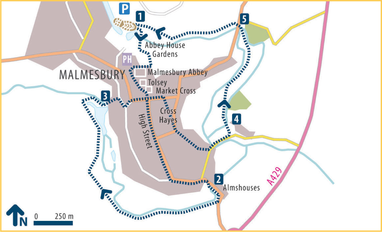
Go along the path between two stone walls then turn right up the sloping path marked Burnivale. Turn left up the stone steps and follow the path to reach Gloucester St. Turn right to return to the Market Cross, then go straight on along Oxford St and turn right into Market La to reach Cross Hayes. Take the road in the opposite corner of the square. This is Silver St, so called because it once contained Malmesburys mint. After a few yards the road gives way to gentle steps, until you reach the bottom of the hill, whereupon you turn left over the bridge and past the bowling green. At the edge of the green, turn left again, down a gravel footpath. This will take you first over a sluice-cum-footbridge and then over a stile into watermeadows.
After a further hundred yards or so, by an old derelict railway line, you will come to another stile. Go over this, keeping between the two courses of the River Avon (the Tetbury branch is alternatively known as the River Ingleburn). Eventually you reach a stile by a road going over a bridge.
Cross the road and take the path immediately in front of the pub car park. Continue along this path, with the river on your left, through the Conygre Mead Nature Reserve to return to the car park.
Points of interest
 Malmesbury claims to be the oldest borough in England, having been granted a charter by Alfred the Great in 880. King Ethelstan, who is buried in the Abbey, later gave land to the town after its menfolk had helped him defeat Norse invaders. This land is still known as Kings Heath. Virtually every building in Malmesbury has its own points of interest and is worth a moment of your time. Here we consider only those that, in the opinion of the author, are quite outstanding.
Abbey House: This fine building was erected in the sixteenth century after William Stumpe had bought the Abbey and its lands after the Dissolution of the Monasteries in the time of Henry VIII. He paid only 1,516 for the entire Abbey property. William Stumpe was a wealthy local clothier who set up his factory inside the Abbey itself, though two years later he gave the nave to the town for use as a church. Abbey House Gardens have been developed since 1994 and are open 11am5.30pm daily 21 Marend Oct.





 Malmesbury claims to be the oldest borough in England, having been granted a charter by Alfred the Great in 880. King Ethelstan, who is buried in the Abbey, later gave land to the town after its menfolk had helped him defeat Norse invaders. This land is still known as Kings Heath. Virtually every building in Malmesbury has its own points of interest and is worth a moment of your time. Here we consider only those that, in the opinion of the author, are quite outstanding.