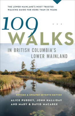
Mary Macaree - 109 Walks in British Columbias Lower Mainland
Here you can read online Mary Macaree - 109 Walks in British Columbias Lower Mainland full text of the book (entire story) in english for free. Download pdf and epub, get meaning, cover and reviews about this ebook. year: 2014, publisher: Greystone Books, genre: Home and family. Description of the work, (preface) as well as reviews are available. Best literature library LitArk.com created for fans of good reading and offers a wide selection of genres:
Romance novel
Science fiction
Adventure
Detective
Science
History
Home and family
Prose
Art
Politics
Computer
Non-fiction
Religion
Business
Children
Humor
Choose a favorite category and find really read worthwhile books. Enjoy immersion in the world of imagination, feel the emotions of the characters or learn something new for yourself, make an fascinating discovery.

- Book:109 Walks in British Columbias Lower Mainland
- Author:
- Publisher:Greystone Books
- Genre:
- Year:2014
- Rating:3 / 5
- Favourites:Add to favourites
- Your mark:
109 Walks in British Columbias Lower Mainland: summary, description and annotation
We offer to read an annotation, description, summary or preface (depends on what the author of the book "109 Walks in British Columbias Lower Mainland" wrote himself). If you haven't found the necessary information about the book — write in the comments, we will try to find it.
Mary Macaree: author's other books
Who wrote 109 Walks in British Columbias Lower Mainland? Find out the surname, the name of the author of the book and a list of all author's works by series.


109 Walks in British Columbias Lower Mainland — read online for free the complete book (whole text) full work
Below is the text of the book, divided by pages. System saving the place of the last page read, allows you to conveniently read the book "109 Walks in British Columbias Lower Mainland" online for free, without having to search again every time where you left off. Put a bookmark, and you can go to the page where you finished reading at any time.
Font size:
Interval:
Bookmark:
Squamish Howe Sound
Brohm Lake and Powerline Trails: 7.2 km (4.5 mi) Allow: 3 hours
Brohm Lake circuit: 4 km (2.5 mi) Allow: 1.5 hours
Surface: rough
Elevation gain: 105 m (345 ft)
High point: 390 m (1280 ft)
Rating: moderate to challenging
Season: May to November
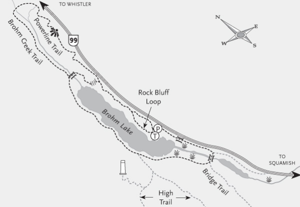
ACCESS
Vehicle: On Highway 99 (Sea to Sky Highway), drive 4.5 km (2.8 mi) north of Alice Lake Road (north of Brackendale) to a parking lot partially hidden by trees on the west side of the highway.
Car GPS entry: Sea to Sky Highway & Alice Lake Road
Trailhead: 49 49.324 N, 123 8.014 W
HIKERS, SWIMMERS AND fisherfolk are all attracted to beautiful Brohm Lake on a nice day, so plan to arrive early, as parking is limited. Roadside parking, where allowed, is strictly enforced by authorities. The popular lake loop carries you up and down from waters edge to bluffy overlooks, along soft-footed track and over longish stairways.
Ease into your walk by going south on a gentle trail paralleling the highway, crossing the bridge over the reedy narrows and turning north (right) at the fork where the Bridge Trail goes left. Now you begin your upsy-downsy way along the lake, passing occasional interpretive signs in the trees, blackened remains from a 1953 forest fire, 200-plus-year-old survivors of logging during the 1930s to 1960s and the occasional approach to waters edge. Stay on the Brohm Lake Trail past the fork leading to the High Trail before arriving at a junction with the now defunct Thompson Trail. Continue another 100 m to another junction where left becomes the Brohm Creek then Powerline Trail. To complete your loop of the lake, go right across a connector trail, up and down several sets of stairs that may be slippery when wet, over moss- and fern-covered cliffs with peek-a-boo views of the lake and mountains, and past huge boulders (erratics) left by retreating glaciers, before arriving at your vehicle. (Another trail, which forks left around the Rock Bluff Loop, drops more quickly to the parking lot.)
Alternatively, instead of taking the connector trail, continue onto the Brohm Creek Trail, which follows a peaceful, mossy old logging road near the creek for 1 km (0.6 mi) or so before swinging right across the creek and towards the adjacent highway. Peer into the wooded slopes to see what looks like a giant game of pick-up sticks. These fallen logs are thinnings, cut to reduce competition for nutrients and sunlight in a forest being managed for future logging. At the creek crossing, the trail becomes known as the Powerline Trail, following, as it does, B.C. Hydros 500,000-volt transmission right-of-way, which carries electricity south from the Peace River. B.C. Hydro ensures that the power lines are clear of trees, but the trail itself may be shrubby and requires a sharp eye as it climbs up and down in steep, well-built sections. Once you gain the rocky knolls for a rest, you are rewarded with views of the spectacular Tantalus Range dominating the horizon. Continue south on the trail to return to your start, keeping left at the fork with the previously mentioned connector trail.
West Vancouver
Return: 4 km (2.5 mi) Allow: 1.5 hours
Surface: trail, paved
Rating: easy
Season: all year
ACCESS
Transit: various to Marine Drive at Nelson; join the route at Wellington, one block west
Vehicle: Travelling west on Highway 1/99 (Upper Levels Highway), take Exit 2 (Marine DriveEagleridge), veer left to cross the overpass, then stay with Marine Drive to Whtyecliff Park.
Car GPS entry: Marine Drive & Dufferin Avenue
Trailhead: 49 22.374 N, 123 17.378 W
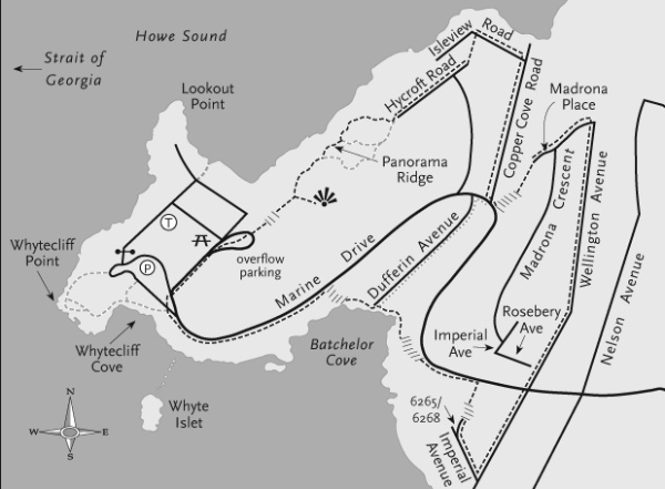
WHYTECLIFF PARK AND Batchelor Cove are two worthwhile destinations at the westernmost end of West Vancouver. This outing links the two via a route along a natural ridge and along streets through attractive residential areas where you may follow your own inclinations.
On foot in Whytecliff Park, head towards the far end of the overflow parking lot to find the start of a steepish trail to Panorama Ridge, built over a waterline and, interestingly, through a not insignificant rock cut. What were once, undoubtedly, impressive views are now obstructed by tall trees, except for a snapshot north to Mount Brunswick and Mount Harvey, with its nearby junior summit known as Harveys Pup. Choosing left forks as you proceed brings you to the northern margin of the park. (If you wish to take only a short outing, turn back right, then left, rejoining your outward route for a return to the busier regions of the park. Now, you may drop down to the shore at Whyte Cove, then, if the tide is favourable, cross the causeway to Whyte Islet.)
For a longer circuit, mainly on streets, descend Hycroft Road at the parks northern extremity and go left at its bend on a track connecting with Isleview Road. Walk down Isleview to its junction with Copper Cove Road, where you turn right. As you walk, look for a few houses that appear to date from the early cottage days. Once at Marine Drive, you have a choice: a jog right then left onto Dufferin Avenue takes you to Batchelor Cove, a secluded little beach enclosed by rocky cliffs; alternatively, a jog left then quickly left again puts you onto an inconspicuous track with stairs up to Madrona Place. At Madrona Crescent, go left to Wellington Avenue.
Now its an easy stride down Wellington, with an occasional backwards glance to the distant mountains, until you cross Rosebery Avenue and Marine Drive in quick succession, then, just when you think you are approaching a dead end, you go right on Imperial Avenue, another cul-de-sac! But look for the stone stairs between house numbers 6265 and 6268, which, despite first impressions, are public and lead to Marine Drive. Now, a few metres to your left, you escape the busy road down another set of steps, down to Batchelor Cove.
Finally, to make your retreat, follow the sand or the boardwalk and trail to the western end of the cove, where stairs ascend to Marine Drive and a picturesque 5-minute walk back to your vehicle.
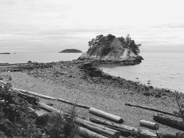
Whyte Islet.
North Surrey Langley
Heritage site return: 5 km (3.1 mi) Allow: 1.5 hours
Including Houston Trail loop: 8 km (5 mi) Allow: 2.5 hours
Surface: improved
Rating: easy
Season: all year
ACCESS
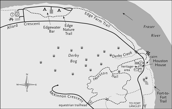
Vehicle: From Highway 1, take Exit 58 (200 Street) north, go along the 201 Street diversion to 96 Avenue, turn east, continue to 208 Street, go left (north) and stay with 208 as it curves east onto Allard Crescent. Continue about 2 km (1.2 mi) to the entrance to Edgewater Bar on your left.
Car GPS entry: 208 Street & Allard Crescent (Langley Township)
Trailhead: 49 12.485 N, 122 37.040 W
POPULAR WITH WALKERS, family cyclists and dog walkers, this well-groomed trail follows the inner bend of the Fraser River from Edgewater Bar to a cairn marking the location of the original Fort Langley. En route, you may be treated to magnificent views of the Golden Ears mountains, log-sorting activities across the water, hungry birds looking for lunch and perhaps a curious seal.
Begin your walk by approaching the river and going right at the campground onto the Edge Nature Trail. (It is named for the Edge family, who once farmed here. A member of the family was killed nearby, in January 1880, when a massive landslide into the Fraser on the Haney side inundated the rivers south shore and caused severe destruction.) The Edge Trail winds through woodlands with imposing cottonwood trees and old stumps for 1 km (0.6 mi) until it nears the river again at the end of the campground. A few steps along it then becomes Edge Farm Trail. The path stays close to the waters edge. Repeat visitors will notice the Frasers changing moods: high water attacks and erodes the riverbanks; low water exposes muddy beaches to explore. After a short diversion beside the road, you reach the heritage area, where you can learn about and imagine life at the time of European settlement.
Font size:
Interval:
Bookmark:
Similar books «109 Walks in British Columbias Lower Mainland»
Look at similar books to 109 Walks in British Columbias Lower Mainland. We have selected literature similar in name and meaning in the hope of providing readers with more options to find new, interesting, not yet read works.
Discussion, reviews of the book 109 Walks in British Columbias Lower Mainland and just readers' own opinions. Leave your comments, write what you think about the work, its meaning or the main characters. Specify what exactly you liked and what you didn't like, and why you think so.