The greater Melbourne region has a unique array of unspoilt natural habitats. You dont have to travel far to find yourself deep in towering eucalypt forest, exploring wetlands around historic sites, swimming in sheltered coves, or scampering along untamed cliff-tops. The Walks in Nature trails are all within a two and a half hour drive of Melbourne.
As southern Victorias climate and landscape vary considerably over the year, the cards are organised seasonally. Our walking cards have been colour-coded into seasons. Our summer cards are light blue, our autumn cards are orange, our winter cards are navy and our spring cards are green. Coastal walks promise cool breezes in summer, inland walks through vineyards and farmland take on the colours of autumn, walks closer to the city centre can be enjoyed during the shorter daylight hours of winter, and walks passing native flowering plants are spectacular in spring.
For each walk, theres a clear and detailed map and information on what youll see along the way, as well as a suggested place to stop for a coffee, a light meal, or to buy delicious local food for a picnic.
This guide is a collaboration between Diana Carlile, a passionate walker, and Anna Carlile of Viola Design, a communication design company that draws inspiration from nature and encourages design that celebrates and protects the environment. www.violadesign.com.au
viola design
ph 03 9654 0402
247 Flinders Lane, Melbourne,
Victoria 3000, Australia
www.violadesign.com.au
CONTENTS
SUMMER
AUTUMN
WINTER
SPRING

Cape Schanck
Kasia Pawlikowski
A cliff-top walk from Bushrangers Bay to Cape Schanck with eucalypts, banksias and geological formations.
This is a spectacular trail, skirting rugged coastline battered by the wild waters of Bass Strait. Follow the Main Creek Track from the carpark to Bushrangers Bay. The eucalypt forest gradually gives way to shady thickets of coast banksia as the trail comes to an isolated sandy beach fringed by pitted basalt cliffs. Continue along the deep red and grey cliffs to Cape Schanck. The 1850s stone lighthouse overlooks a boardwalk that descends the rocky promontory, which looks back over the trail to a pebbled beach surrounded by sculptural volcanic forms. You can find a sheltered spot behind the lighthouse cottage for a picnic. After returning, head to Flinders Bakehouse Cafe (60 Cook St) for their coffee and fruit loaf.
Location
109 km south
from Melbourne
Distance
13 km return
Grade
Medium
Map
Melway 259 K8
UBD 513 A7
Notes
Do not walk on fire ban day
No dogs
Track unsealed


Mornington Peninsula National Park
Helen Grodski
Native bushland walk through the fern gullies and towering eucalypt forests of Mornington Peninsula National Park.
The sheltered walk follows a rippling creek through cool forest the largest area of remnant bushland on the peninsula, and home to the largest population of eastern grey kangaroos. From the picnic area at Baldry Crossing, cross the road and take the left-most opening to the circuit track. Kangaroos, wallabies, parrots, honey eaters and black cockatoos can be seen in the bracken understorey and amongst the eucalypts. Turn left onto the Two Bays Walking Track and follow the signs toward Bushrangers Bay. Before returning, theres a restful spot for a picnic at Long Point. Visit the historic town of Flinders after the walk. You can find delicious light meals and coffee at the Red Hill Bakery (37 Cook St).
Location
103 km south
from Melbourne
Distance
14 km return
Grade
Medium
Map
Melway 254 G6
UBD 507 M3
Notes
Do not walk on fire ban day
No dogs
Track unsealed


Barwon River mouth, Barwon Heads
Mark Chew, Tourism Victoria
Coastal walk from Ocean Grove to Barwon Heads along sandy beaches with native wildlife.
The seaside towns of Barwon Heads and Ocean Grove are neighbours across the Barwon River. With old jetties and timber structures, they have a charming, sleepy atmosphere. From the Lookout Reserve carpark, follow the foreshore towards Barwon Heads. Popular with surfers, the long, sandy beach undulates with fragile dunes. You will pass the Ocean Grove Surf Life Saving Club where Dunes Cafe is located (Surf Beach Rd). Have a coffee and admire the great views over the ocean. Continue on to Barwon Heads, cross the bridge over the Barwon River and walk towards the Bluff. From here, the view looks out across the beach and sweeping coastal vegetation to the Great Ocean Rd and the expansive Bass Strait. Return along the shallow Barwon River estuary, where there are lovely spots for a picnic.
Location
100 km southwest from Melbourne
Distance
12 km return
Grade
Medium
Map
Melway 497 J1 UBD 664 B20
Notes
No dogs
Track unsealed


View of the bay from Seawinds Gardens
Helen Grodski
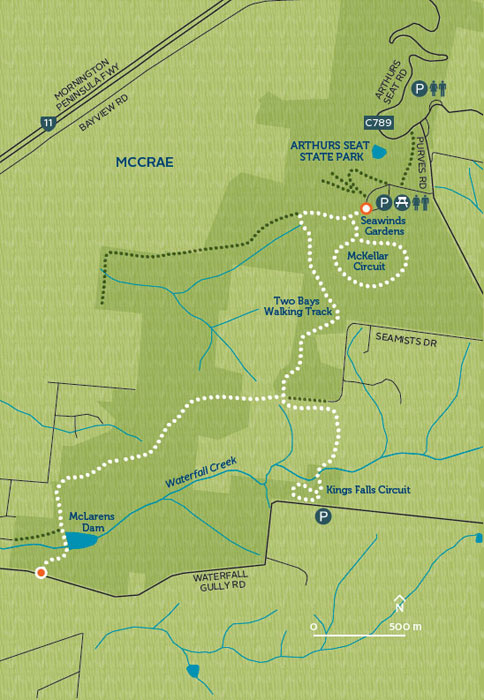
A walk through eucalypt and fern forest with numerous vantage points to enjoy the expansive view of Port Phillip.
After picking up a delicious picnic lunch from Red Hill Caterers Cafe and Store (5 MorningtonFlinders Rd), head to the formal Seawinds Gardens. Lined with mature oaks, the gardens tilt toward a view of the bay and, on a clear day, you can see Melbournes skyline, Bellarine Peninsula and the granite You Yangs. From the McKellar Circuit, turn left onto the Two Bays Walking Track. The track passes through a cross section of the peninsulas landscape: mixed eucalypt and grass tree forest gives way to ferns, including the delicate scrambling coral fern. Stop for a picnic along the way. After completing the Kings Falls Circuit Walk, continue to Waterfall Gully Rd. When you have finished, you can drop into Red Hill Cheese (81 William Rd) and sample some organic cheese.
Location
94 km south
from Melbourne
Distance
14 km return
Grade
Medium
Map
Melway 159 E12 UBD 487 H15
Notes
Do not walk on fire ban day
No dogs
Track unsealed
