HARPER COLLINS
ATLAS OF
BIBLE HISTORY


The aim of this book is to provide a general overview of the events of Bible times; the wars, journeys, migrations, rebellions, and invasions which, both recorded in the text of the Bible and beyond, throw light on the people, lands, and culture of the biblical world.
The foreword to the original edition of this Atlas, written in 1990, emphasized the extent to which archaeology was having an impact on the field of biblical studies. Since then, its impact has only gained momentum, with scholars drawing on data from a wide range of archaeological disciplines.
Whereas, in its early days, apologetics supplied one of the main motivations behind archaeology, in recent years the driving force has been a desire to explore the wider context of the world in which the characters from the Bible lived. Discoveries relating to travel, commerce, living conditions, and social and religious activities have given new life to the accounts in both the Old and New Testaments.
Recent archaeological finds are continuing to redefine the relationship between the Bible and history. For example, the publication of the Cave 4 fragments of the Dead Sea Scrolls in the 1990s gave a new angle to early Judaism and the origins of Christianity. Even during the preparation of this edition, there came claims of the discovery of Herod the Greats tomb at the Herodion, a possible mention of a Babylonian official mentioned in Jeremiah on a clay tablet in the British Museum, and the discovery of an ancient village just to the north of Jerusalem.
Of course, archaeology is a matter of interpretation and opinion as well as investigation; and such opinions become particularly acute when the Bible is involved. For example, the issue of ancient chronology - especially Egyptian - excites much debate and discussion. Ancient dating was by means of regnal years of different rulers, rather than the kind of dating we are used to today. So, absolute dates are hard to determine, and have to be established through other means. Some dates can be checked by cross-referencing the same event as dated by two different cultures; others by means of astronomy. However, there remain huge areas of uncertainty, especially beyond the seventh century BC. For the most part the dating preferences of the original edition have been kept. However, for the dates of the Egyptian rulers, this new edition follows the preferred chronology of the Department of Egyptian Antiquities in the British Museum.
One of the most important factors for understanding the Bible, whether as an historian, a theologian, or a general reader, is an understanding of the historical context. The aim of the HarperCollins Atlas of Bible History is to provide the reader with all the information they need to acquire this understanding, in a way that is accessible, informed, and visually stimulating.
Contents
ONE
S ETTING THE S CENE
TWO
T HE P ATRIARCHS
THREE
E GYPT AND THE E XODUS
FOUR
C ONQUEST AND O CCUPATION
FIVE
T HE U NITED K INGDOM
SIX
T HE D IVIDED K INGDOM
SEVEN
B ETWEEN THE T ESTAMENTS
EIGHT
P ALESTINE UNDER THE R OMANS
NINE
T HE E ARLY C HURCH
TEN
B EYOND THE TIMES OF THE B IBLE
ONE
SETTING THE SCENE
Palestine has always been something of a gateway. Geographically, it serves as a land-bridge between Asia and Africa; historically, it was an important route between the two centers of ancient civilization: Mesopotamia and Egypt.
The land has a basic relief of rounded mountains and incised valleys, which have determined the pattern of major roads. Seen from the west, Palestine consists of a coastal plain, a lowland, and two lines of mountains, divided by the great rift that runs southward from Syria to the source of the African river Zambezi.
The river Jordan runs through the Palestinian section of this rift. Indeed, the Jordan depression is a unique feature of the physical geography of Palestine. The point where the river enters the Dead Sea is the lowest point on the land surface of the Earth, some 393m (1280 ft) below sea level. Appropriately, the name Jordan means the descender.
Palestine lies in a subtropical zone, with a long dry summer and a short rainy season in winter. Precipitation varies greatly. The northern mountains of Carmel, Upper Galilee and northern Samaria were once covered with dense woodland sustained by the fair amount of rain. Now, however, only a narrow strip along the Mediterranean enjoys a relatively large amount of rainfall. Desert surrounds Palestine on the south and east.
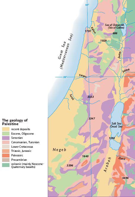
The geography of the country is directly related to the quality of the soil (map right). Palestines most fertile soil derives from the Cenomanian limestone, which, with adequate rainfall, breaks down into the rich terra rossa. The Senonian chalk is easily eroded and is infertile. Numbers indicate elevations in feet.
The geology of the land has had a huge impact on human activities. The hard limestone in the hills of Palestine weathers into a rich red-brown soil called terra rossa, ideal for farming. However, the soft limestone (the intermediate Senonian rock) tends to erode into a gray infertile soil. Building stone was quarried from the limestone rocks of Cenomanian, Turonian, and Eocene formations. Quarries have been found at Megiddo, Samaria, and Ramat Rahel in Iron Age contexts. Basalt exists in eastern Galilee and in the Golan; since prehistoric times, it has been the basic material for making querns and mortars.
Palestine is not very rich in mineral resources. A thick layer of red Nubian sandstone, containing deposits of copper, is known from southern Transjordan and around the river Jabbok; iron is mined in the mountains of Transjordan. Salt is obtained from the Mediterranean or from the Dead Sea.
Agriculture
The economy of Palestine has generally been pastoral-agrarian in character. Some plant species have migrated from as far away as Western Europe, Central Asia, and Central Africa. Agriculture has traditionally been based on grain, wine, and olive oil. Barley was usually grown in areas of poor soil and limited precipitation. Supplementing these were figs, pomegranates, dates, and almonds. Terraces were frequently built in serried fashion on the slopes of hills for farming. Easy access between fields and the marketplaces was vital, and in many areas of Palestine a complex network of regional and rural roads was established.
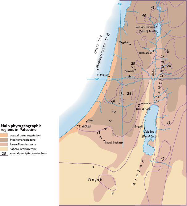
Major climatic and floral zones in Palestine (map right). Lines show average yearly rainfall in inches.
The great variety of soil and rainfall makes for a diversity of flora. In the narrow belt of land known as the Mediterranean zone, the climate is characterized by a short, wet winter with an annual total rainfall of between 15.5 and 47.25 in. The zone originally supported evergreen woodlands and high maquis vegetation, but this has now been destroyed. The typical trees are the Aleppo pine, the common oak, the Palestine terebinth, the laurel, the carob, and the mastic terebinth.


